
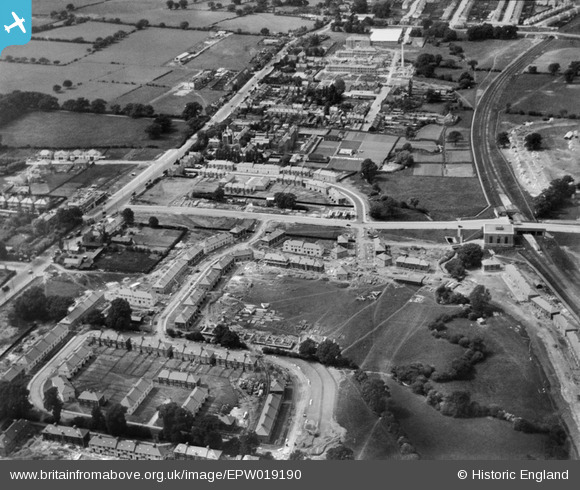
EPW019190 ENGLAND (1927). Watling Avenue, Burnt Oak, 1927
© Copyright OpenStreetMap contributors and licensed by the OpenStreetMap Foundation. 2025. Cartography is licensed as CC BY-SA.
Nearby Images (20)
EPW019190

EPW019191

EPW009346

EPW001350

EPW009682

EPW009345

EPW009344

EPW016519

EPW009347

EPW016517

EPW009363

EPW031549

EPW019193

EPW031548

EAW020696

EPW031583

EPW019336

EPW017584

EPW017380

EPW031550

Details
| Title | [EPW019190] Watling Avenue, Burnt Oak, 1927 |
| Reference | EPW019190 |
| Date | August-1927 |
| Link | |
| Place name | BURNT OAK |
| Parish | |
| District | |
| Country | ENGLAND |
| Easting / Northing | 520233, 190584 |
| Longitude / Latitude | -0.26379559249901, 51.600774918135 |
| National Grid Reference | TQ202906 |
Pins
 Danish A |
Saturday 24th of August 2013 05:28:26 PM | |
Danish A |
Saturday 24th of August 2013 05:24:33 PM | |
bazouteast |
Tuesday 11th of December 2012 12:08:24 PM | |
bazouteast |
Tuesday 11th of December 2012 12:06:26 PM | |
bazouteast |
Tuesday 11th of December 2012 12:06:04 PM | |
bazouteast |
Tuesday 11th of December 2012 12:05:39 PM | |
bazouteast |
Tuesday 11th of December 2012 12:05:22 PM | |
bazouteast |
Tuesday 11th of December 2012 12:05:01 PM |
User Comment Contributions
 The building of the Watling estate received a lot attention from AeroFilms. It was an important project right their doorstep so we now have the benefit of a mass of fine photographs to view the estate's development. The estate is almost a twin of the LCC estate at Beacontree in Essex. Watling Ave runs across the middle of the picture, the future site of Barnfield school just below it. The shops on the Watling have yet to be built. At the top left hand corner empty fields can be seen but in little more than two years these would be filled by the Canada Park estate. |
colsouth111 |
Thursday 20th of June 2013 11:44:21 AM |
Walking down Watling Avenue towards the station, my Dad's shop was on the left hand side. No sign yet of the Co-op on the main road. |
Norman Vickery |
Thursday 20th of June 2013 11:44:21 AM |