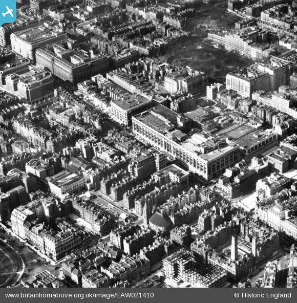
EAW021410 ENGLAND (1949). Selfridges and environs, Marylebone, 1949. This image has been produced from a print.
© Copyright OpenStreetMap contributors and licensed by the OpenStreetMap Foundation. 2025. Cartography is licensed as CC BY-SA.
Nearby Images (40)
Details
| Title | [EAW021410] Selfridges and environs, Marylebone, 1949. This image has been produced from a print. |
| Reference | EAW021410 |
| Date | 15-March-1949 |
| Link | |
| Place name | MARYLEBONE |
| Parish | |
| District | |
| Country | ENGLAND |
| Easting / Northing | 528253, 181081 |
| Longitude / Latitude | -0.15151386704749, 51.513595079072 |
| National Grid Reference | TQ283811 |
Pins
 brianbeckett |
Tuesday 21st of October 2014 07:59:26 PM | |
 brianbeckett |
Tuesday 21st of October 2014 07:57:57 PM | |
 Alan McFaden |
Thursday 11th of September 2014 09:05:21 AM | |
 Alan McFaden |
Thursday 11th of September 2014 09:04:53 AM | |
 Alan McFaden |
Thursday 11th of September 2014 09:04:15 AM |


![[EAW021410] Selfridges and environs, Marylebone, 1949. This image has been produced from a print.](http://britainfromabove.org.uk/sites/all/libraries/aerofilms-images/public/100x100/EAW/021/EAW021410.jpg)
![[EPW021936] Selfridges Department Store, Westminster, 1928](http://britainfromabove.org.uk/sites/all/libraries/aerofilms-images/public/100x100/EPW/021/EPW021936.jpg)
![[EAW021409] Selfridges and environs, Marylebone, 1949. This image has been produced from a print.](http://britainfromabove.org.uk/sites/all/libraries/aerofilms-images/public/100x100/EAW/021/EAW021409.jpg)
![[EPW021935] Selfridges Department Store, Westminster, 1928](http://britainfromabove.org.uk/sites/all/libraries/aerofilms-images/public/100x100/EPW/021/EPW021935.jpg)
![[EPW006306] Selfridges, Westminster, 1921](http://britainfromabove.org.uk/sites/all/libraries/aerofilms-images/public/100x100/EPW/006/EPW006306.jpg)
![[EPW046655] Oxford Street from Marble Arch to Oxford Circus and the surrounding city, Marylebone, from the south-west, 1935](http://britainfromabove.org.uk/sites/all/libraries/aerofilms-images/public/100x100/EPW/046/EPW046655.jpg)
![[EAW021411] Selfridges and environs, Marylebone, 1949. This image has been produced from a print.](http://britainfromabove.org.uk/sites/all/libraries/aerofilms-images/public/100x100/EAW/021/EAW021411.jpg)
![[EAW050867] Oxford Street from Selfridges Department Store to Marble Arch, Westminster, 1953](http://britainfromabove.org.uk/sites/all/libraries/aerofilms-images/public/100x100/EAW/050/EAW050867.jpg)
![[EAW050837] Oxford Street including Selfridges Department Store, Westminster, 1953](http://britainfromabove.org.uk/sites/all/libraries/aerofilms-images/public/100x100/EAW/050/EAW050837.jpg)
![[EAW021412] Selfridges and environs, Marylebone, 1949. This image has been produced from a print.](http://britainfromabove.org.uk/sites/all/libraries/aerofilms-images/public/100x100/EAW/021/EAW021412.jpg)
![[EPW021967] Selfridges Department Store and surroundings, Westminster, 1928](http://britainfromabove.org.uk/sites/all/libraries/aerofilms-images/public/100x100/EPW/021/EPW021967.jpg)
![[EAW050871] Oxford Street including Selfridges Department Store, Westminster, 1953](http://britainfromabove.org.uk/sites/all/libraries/aerofilms-images/public/100x100/EAW/050/EAW050871.jpg)
![[EAW021408] Selfridges and environs, Marylebone, 1949. This image has been produced from a print.](http://britainfromabove.org.uk/sites/all/libraries/aerofilms-images/public/100x100/EAW/021/EAW021408.jpg)
![[EPW046656] Oxford Street from Marble Arch to Holborn and the surrounding city, Marylebone, from the south-west, 1935](http://britainfromabove.org.uk/sites/all/libraries/aerofilms-images/public/100x100/EPW/046/EPW046656.jpg)
![[EPW060755] Park Lane, Oxford Street, Grosvenor Square and the surrounding city, Mayfair, 1939](http://britainfromabove.org.uk/sites/all/libraries/aerofilms-images/public/100x100/EPW/060/EPW060755.jpg)
![[EPW045400] Oxford Street and environs, Westminster, 1934](http://britainfromabove.org.uk/sites/all/libraries/aerofilms-images/public/100x100/EPW/045/EPW045400.jpg)
![[EPW060765] Oxford Street and environs from Marble Arch to the British Museum, Marylebone, 1939](http://britainfromabove.org.uk/sites/all/libraries/aerofilms-images/public/100x100/EPW/060/EPW060765.jpg)
![[EPW045399] Grosvenor Square and environs, Mayfair, 1934](http://britainfromabove.org.uk/sites/all/libraries/aerofilms-images/public/100x100/EPW/045/EPW045399.jpg)
![[EAW052483] Selfridges and environs on Oxford Street, Westminster, 1953](http://britainfromabove.org.uk/sites/all/libraries/aerofilms-images/public/100x100/EAW/052/EAW052483.jpg)
![[EAW052482] Portman Square and environs, Westminster, 1953](http://britainfromabove.org.uk/sites/all/libraries/aerofilms-images/public/100x100/EAW/052/EAW052482.jpg)
![[EAW050854] Oxford Street including Selfridges Department Store, Westminster, 1953](http://britainfromabove.org.uk/sites/all/libraries/aerofilms-images/public/100x100/EAW/050/EAW050854.jpg)
![[EPW021880] Oxford Street, Westminster, 1928](http://britainfromabove.org.uk/sites/all/libraries/aerofilms-images/public/100x100/EPW/021/EPW021880.jpg)
![[EAW050868] Oxford Street including Selfridges Department Store, Westminster, 1953](http://britainfromabove.org.uk/sites/all/libraries/aerofilms-images/public/100x100/EAW/050/EAW050868.jpg)
![[EPR000431] Oxford Street between Park Lane and Selfridges, Westminster, 1934](http://britainfromabove.org.uk/sites/all/libraries/aerofilms-images/public/100x100/EPR/000/EPR000431.jpg)
![[EAW050850] Oxford Street including Selfridges Department Store, Westminster, 1953](http://britainfromabove.org.uk/sites/all/libraries/aerofilms-images/public/100x100/EAW/050/EAW050850.jpg)
![[EPW011416] Oxford Street and environs, Westminster, 1924](http://britainfromabove.org.uk/sites/all/libraries/aerofilms-images/public/100x100/EPW/011/EPW011416.jpg)
![[EAW000563] Marylebone High Street and environs, Marylebone, from the south-east, 1946](http://britainfromabove.org.uk/sites/all/libraries/aerofilms-images/public/100x100/EAW/000/EAW000563.jpg)
![[EPW059412] A cityscape from Marble Arch along Oxford Street, Westminster, 1938](http://britainfromabove.org.uk/sites/all/libraries/aerofilms-images/public/100x100/EPW/059/EPW059412.jpg)
![[EAW000564] Gloucester Place, Baker Street and environs, Marylebone, 1946](http://britainfromabove.org.uk/sites/all/libraries/aerofilms-images/public/100x100/EAW/000/EAW000564.jpg)
![[EPW021405] Oxford Street and environs, Mayfair, from the west, 1928](http://britainfromabove.org.uk/sites/all/libraries/aerofilms-images/public/100x100/EPW/021/EPW021405.jpg)
![[EPW047237] A London cityscape featuring Grosvenor Square, Marylebone, 1935](http://britainfromabove.org.uk/sites/all/libraries/aerofilms-images/public/100x100/EPW/047/EPW047237.jpg)
![[EAW052484] James Street and environs off Oxford Street, Westminster, 1953](http://britainfromabove.org.uk/sites/all/libraries/aerofilms-images/public/100x100/EAW/052/EAW052484.jpg)
![[EAW052481] Oxford Street east of Marble Arch, Westminster, 1953](http://britainfromabove.org.uk/sites/all/libraries/aerofilms-images/public/100x100/EAW/052/EAW052481.jpg)
![[EAW050839] Oxford Street, Westminster, 1953](http://britainfromabove.org.uk/sites/all/libraries/aerofilms-images/public/100x100/EAW/050/EAW050839.jpg)
![[EPW021436] Oxford Street and environs, Marylebone, from the west, 1928](http://britainfromabove.org.uk/sites/all/libraries/aerofilms-images/public/100x100/EPW/021/EPW021436.jpg)
![[EAW025864] Grosvenor Square and environs, Mayfair, 1949. This image has been produced from a copy-negative.](http://britainfromabove.org.uk/sites/all/libraries/aerofilms-images/public/100x100/EAW/025/EAW025864.jpg)
![[EAW029834] Marble Arch and Oxford Street, Mayfair, from the west, 1950](http://britainfromabove.org.uk/sites/all/libraries/aerofilms-images/public/100x100/EAW/029/EAW029834.jpg)
![[EAW025864A] Grosvenor Square (extract from negative A25864), Mayfair, 1949. This image has been produced from a copy-negative.](http://britainfromabove.org.uk/sites/all/libraries/aerofilms-images/public/100x100/EAW/025/EAW025864A.jpg)
![[EAW042622] Grosvenor Square, Mayfair, 1952](http://britainfromabove.org.uk/sites/all/libraries/aerofilms-images/public/100x100/EAW/042/EAW042622.jpg)
![[EAW030118] Oxford Street and the city, Mayfair, from the west, 1950](http://britainfromabove.org.uk/sites/all/libraries/aerofilms-images/public/100x100/EAW/030/EAW030118.jpg)


