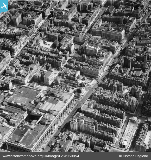
EAW050854 ENGLAND (1953). Oxford Street including Selfridges Department Store, Westminster, 1953
© Copyright OpenStreetMap contributors and licensed by the OpenStreetMap Foundation. 2025. Cartography is licensed as CC BY-SA.
Nearby Images (28)
Details
| Title | [EAW050854] Oxford Street including Selfridges Department Store, Westminster, 1953 |
| Reference | EAW050854 |
| Date | 23-July-1953 |
| Link | |
| Place name | WESTMINSTER |
| Parish | |
| District | |
| Country | ENGLAND |
| Easting / Northing | 528413, 181144 |
| Longitude / Latitude | -0.14918615653981, 51.514124958947 |
| National Grid Reference | TQ284811 |
Pins
 Alan McFaden |
Thursday 11th of September 2014 09:14:21 AM | |
 Alan McFaden |
Thursday 11th of September 2014 09:13:58 AM |


![[EAW050854] Oxford Street including Selfridges Department Store, Westminster, 1953](http://britainfromabove.org.uk/sites/all/libraries/aerofilms-images/public/100x100/EAW/050/EAW050854.jpg)
![[EAW050868] Oxford Street including Selfridges Department Store, Westminster, 1953](http://britainfromabove.org.uk/sites/all/libraries/aerofilms-images/public/100x100/EAW/050/EAW050868.jpg)
![[EAW050850] Oxford Street including Selfridges Department Store, Westminster, 1953](http://britainfromabove.org.uk/sites/all/libraries/aerofilms-images/public/100x100/EAW/050/EAW050850.jpg)
![[EAW052483] Selfridges and environs on Oxford Street, Westminster, 1953](http://britainfromabove.org.uk/sites/all/libraries/aerofilms-images/public/100x100/EAW/052/EAW052483.jpg)
![[EAW000563] Marylebone High Street and environs, Marylebone, from the south-east, 1946](http://britainfromabove.org.uk/sites/all/libraries/aerofilms-images/public/100x100/EAW/000/EAW000563.jpg)
![[EPW060765] Oxford Street and environs from Marble Arch to the British Museum, Marylebone, 1939](http://britainfromabove.org.uk/sites/all/libraries/aerofilms-images/public/100x100/EPW/060/EPW060765.jpg)
![[EPW047237] A London cityscape featuring Grosvenor Square, Marylebone, 1935](http://britainfromabove.org.uk/sites/all/libraries/aerofilms-images/public/100x100/EPW/047/EPW047237.jpg)
![[EPW046656] Oxford Street from Marble Arch to Holborn and the surrounding city, Marylebone, from the south-west, 1935](http://britainfromabove.org.uk/sites/all/libraries/aerofilms-images/public/100x100/EPW/046/EPW046656.jpg)
![[EPW021967] Selfridges Department Store and surroundings, Westminster, 1928](http://britainfromabove.org.uk/sites/all/libraries/aerofilms-images/public/100x100/EPW/021/EPW021967.jpg)
![[EAW052484] James Street and environs off Oxford Street, Westminster, 1953](http://britainfromabove.org.uk/sites/all/libraries/aerofilms-images/public/100x100/EAW/052/EAW052484.jpg)
![[EAW050871] Oxford Street including Selfridges Department Store, Westminster, 1953](http://britainfromabove.org.uk/sites/all/libraries/aerofilms-images/public/100x100/EAW/050/EAW050871.jpg)
![[EAW021412] Selfridges and environs, Marylebone, 1949. This image has been produced from a print.](http://britainfromabove.org.uk/sites/all/libraries/aerofilms-images/public/100x100/EAW/021/EAW021412.jpg)
![[EPW046655] Oxford Street from Marble Arch to Oxford Circus and the surrounding city, Marylebone, from the south-west, 1935](http://britainfromabove.org.uk/sites/all/libraries/aerofilms-images/public/100x100/EPW/046/EPW046655.jpg)
![[EPW059412] A cityscape from Marble Arch along Oxford Street, Westminster, 1938](http://britainfromabove.org.uk/sites/all/libraries/aerofilms-images/public/100x100/EPW/059/EPW059412.jpg)
![[EAW021411] Selfridges and environs, Marylebone, 1949. This image has been produced from a print.](http://britainfromabove.org.uk/sites/all/libraries/aerofilms-images/public/100x100/EAW/021/EAW021411.jpg)
![[EAW050839] Oxford Street, Westminster, 1953](http://britainfromabove.org.uk/sites/all/libraries/aerofilms-images/public/100x100/EAW/050/EAW050839.jpg)
![[EPW021443] Oxford Circus and Oxford Street, Marylebone, from the west, 1928](http://britainfromabove.org.uk/sites/all/libraries/aerofilms-images/public/100x100/EPW/021/EPW021443.jpg)
![[EPW006306] Selfridges, Westminster, 1921](http://britainfromabove.org.uk/sites/all/libraries/aerofilms-images/public/100x100/EPW/006/EPW006306.jpg)
![[EAW021408] Selfridges and environs, Marylebone, 1949. This image has been produced from a print.](http://britainfromabove.org.uk/sites/all/libraries/aerofilms-images/public/100x100/EAW/021/EAW021408.jpg)
![[EAW021409] Selfridges and environs, Marylebone, 1949. This image has been produced from a print.](http://britainfromabove.org.uk/sites/all/libraries/aerofilms-images/public/100x100/EAW/021/EAW021409.jpg)
![[EPW021935] Selfridges Department Store, Westminster, 1928](http://britainfromabove.org.uk/sites/all/libraries/aerofilms-images/public/100x100/EPW/021/EPW021935.jpg)
![[EPW045399] Grosvenor Square and environs, Mayfair, 1934](http://britainfromabove.org.uk/sites/all/libraries/aerofilms-images/public/100x100/EPW/045/EPW045399.jpg)
![[EAW021410] Selfridges and environs, Marylebone, 1949. This image has been produced from a print.](http://britainfromabove.org.uk/sites/all/libraries/aerofilms-images/public/100x100/EAW/021/EAW021410.jpg)
![[EPW021936] Selfridges Department Store, Westminster, 1928](http://britainfromabove.org.uk/sites/all/libraries/aerofilms-images/public/100x100/EPW/021/EPW021936.jpg)
![[EPW060755] Park Lane, Oxford Street, Grosvenor Square and the surrounding city, Mayfair, 1939](http://britainfromabove.org.uk/sites/all/libraries/aerofilms-images/public/100x100/EPW/060/EPW060755.jpg)
![[EPW006304] View of Oxford Street and environs, Westminster, from the west, 1921](http://britainfromabove.org.uk/sites/all/libraries/aerofilms-images/public/100x100/EPW/006/EPW006304.jpg)
![[EAW050867] Oxford Street from Selfridges Department Store to Marble Arch, Westminster, 1953](http://britainfromabove.org.uk/sites/all/libraries/aerofilms-images/public/100x100/EAW/050/EAW050867.jpg)
![[EPW045400] Oxford Street and environs, Westminster, 1934](http://britainfromabove.org.uk/sites/all/libraries/aerofilms-images/public/100x100/EPW/045/EPW045400.jpg)

