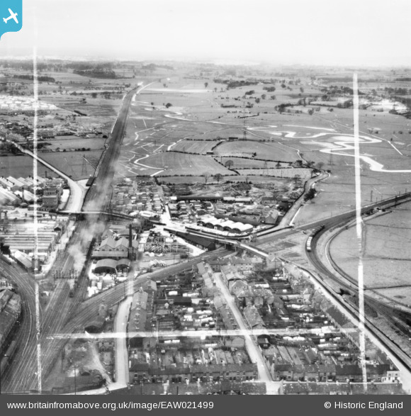
EAW021499 ENGLAND (1949). Henry Venables Ltd Castletown Saw Mill and environs, Stafford, from the south-east, 1949. This image has been produced from a print marked by Aerofilms Ltd for photo editing.
© Copyright OpenStreetMap contributors and licensed by the OpenStreetMap Foundation. 2025. Cartography is licensed as CC BY-SA.
Nearby Images (35)
Details
| Title | [EAW021499] Henry Venables Ltd Castletown Saw Mill and environs, Stafford, from the south-east, 1949. This image has been produced from a print marked by Aerofilms Ltd for photo editing. |
| Reference | EAW021499 |
| Date | 15-March-1949 |
| Link | |
| Place name | STAFFORD |
| Parish | |
| District | |
| Country | ENGLAND |
| Easting / Northing | 391575, 323329 |
| Longitude / Latitude | -2.1249952382366, 52.807114796265 |
| National Grid Reference | SJ916233 |
Pins
 iain1940 |
Saturday 19th of October 2019 06:39:34 PM |


![[EAW021499] Henry Venables Ltd Castletown Saw Mill and environs, Stafford, from the south-east, 1949. This image has been produced from a print marked by Aerofilms Ltd for photo editing.](http://britainfromabove.org.uk/sites/all/libraries/aerofilms-images/public/100x100/EAW/021/EAW021499.jpg)
![[EAW021494] Henry Venables Ltd Castletown Saw Mill and environs, Stafford, from the south-east, 1949. This image has been produced from a print marked by Aerofilms Ltd for photo editing.](http://britainfromabove.org.uk/sites/all/libraries/aerofilms-images/public/100x100/EAW/021/EAW021494.jpg)
![[EAW015401] W.G. Bagnall Ltd Castle Engine Works and environs, Castletown, 1948. This image has been produced from a print.](http://britainfromabove.org.uk/sites/all/libraries/aerofilms-images/public/100x100/EAW/015/EAW015401.jpg)
![[EAW021495] Henry Venables Ltd Castletown Saw Mill and environs, Stafford, from the south-east, 1949. This image has been produced from a print marked by Aerofilms Ltd for photo editing.](http://britainfromabove.org.uk/sites/all/libraries/aerofilms-images/public/100x100/EAW/021/EAW021495.jpg)
![[EAW015404] W.G. Bagnall Ltd Castle Engine Works, Castletown, 1948. This image has been produced from a print.](http://britainfromabove.org.uk/sites/all/libraries/aerofilms-images/public/100x100/EAW/015/EAW015404.jpg)
![[EAW001871] The Castletown Saw Mills and the surrounding area, Stafford, 1946](http://britainfromabove.org.uk/sites/all/libraries/aerofilms-images/public/100x100/EAW/001/EAW001871.jpg)
![[EAW021603] Henry Venables Ltd Castletown Saw Mill, Stafford, 1949. This image has been produced from a print marked by Aerofilms Ltd for photo editing.](http://britainfromabove.org.uk/sites/all/libraries/aerofilms-images/public/100x100/EAW/021/EAW021603.jpg)
![[EAW021600] Henry Venables Ltd Castletown Saw Mill, Stafford, 1949. This image has been produced from a print marked by Aerofilms Ltd for photo editing.](http://britainfromabove.org.uk/sites/all/libraries/aerofilms-images/public/100x100/EAW/021/EAW021600.jpg)
![[EAW021602] Henry Venables Ltd Castletown Saw Mill, Stafford, 1949. This image has been produced from a print marked by Aerofilms Ltd for photo editing.](http://britainfromabove.org.uk/sites/all/libraries/aerofilms-images/public/100x100/EAW/021/EAW021602.jpg)
![[EAW015406] W.G. Bagnall Ltd Castle Engine Works, Castletown, 1948. This image has been produced from a print marked by Aerofilms Ltd for photo editing.](http://britainfromabove.org.uk/sites/all/libraries/aerofilms-images/public/100x100/EAW/015/EAW015406.jpg)
![[EAW000385] The Universal Grinding Wheel Works and the village, Doxey, from the east, 1946. This image has been produced from a damaged negative.](http://britainfromabove.org.uk/sites/all/libraries/aerofilms-images/public/100x100/EAW/000/EAW000385.jpg)
![[EAW021601] Henry Venables Ltd Castletown Saw Mill, Stafford, 1949. This image has been produced from a print marked by Aerofilms Ltd for photo editing.](http://britainfromabove.org.uk/sites/all/libraries/aerofilms-images/public/100x100/EAW/021/EAW021601.jpg)
![[EAW021608] Henry Venables Ltd Castletown Saw Mill, Stafford, 1949. This image has been produced from a print marked by Aerofilms Ltd for photo editing.](http://britainfromabove.org.uk/sites/all/libraries/aerofilms-images/public/100x100/EAW/021/EAW021608.jpg)
![[EAW021604] Henry Venables Ltd Castletown Saw Mill, Stafford, 1949. This image has been produced from a print marked by Aerofilms Ltd for photo editing.](http://britainfromabove.org.uk/sites/all/libraries/aerofilms-images/public/100x100/EAW/021/EAW021604.jpg)
![[EAW001873] The Castletown Saw Mills and the Universal Grinding Wheel Works, Stafford, 1946](http://britainfromabove.org.uk/sites/all/libraries/aerofilms-images/public/100x100/EAW/001/EAW001873.jpg)
![[EAW001868] The Castletown Saw Mills and the Universal Grinding Wheel Works, Stafford, 1946](http://britainfromabove.org.uk/sites/all/libraries/aerofilms-images/public/100x100/EAW/001/EAW001868.jpg)
![[EAW021605] Henry Venables Ltd Castletown Saw Mill alongside the Universal Grinding Wheel Co Ltd Works and environs, Stafford, 1949. This image has been produced from a print marked by Aerofilms Ltd for photo editing.](http://britainfromabove.org.uk/sites/all/libraries/aerofilms-images/public/100x100/EAW/021/EAW021605.jpg)
![[EAW001869] The Castletown Saw Mills and the Universal Grinding Wheel Works, Stafford, 1946](http://britainfromabove.org.uk/sites/all/libraries/aerofilms-images/public/100x100/EAW/001/EAW001869.jpg)
![[EAW001874] The Castletown Saw Mills and the Universal Grinding Wheel Works, Stafford, 1946](http://britainfromabove.org.uk/sites/all/libraries/aerofilms-images/public/100x100/EAW/001/EAW001874.jpg)
![[EAW015403] W.G. Bagnall Ltd Castle Engine Works, Castletown, 1948. This image has been produced from a print.](http://britainfromabove.org.uk/sites/all/libraries/aerofilms-images/public/100x100/EAW/015/EAW015403.jpg)
![[EPW046130] The Universal Grinding Wheel Works and environs, Doxey, from the south-east, 1934](http://britainfromabove.org.uk/sites/all/libraries/aerofilms-images/public/100x100/EPW/046/EPW046130.jpg)
![[EAW021498] Henry Venables Ltd Castletown Saw Mill alongside the Universal Grinding Wheel Co Ltd Works and environs, Stafford, 1949. This image has been produced from a print marked by Aerofilms Ltd for photo editing.](http://britainfromabove.org.uk/sites/all/libraries/aerofilms-images/public/100x100/EAW/021/EAW021498.jpg)
![[EAW000898] The Universal Grinding Wheel Company Ltd, Doxey, 1946](http://britainfromabove.org.uk/sites/all/libraries/aerofilms-images/public/100x100/EAW/000/EAW000898.jpg)
![[EAW015405] W.G. Bagnall Ltd Castle Engine Works, Castletown, 1948. This image has been produced from a print marked by Aerofilms Ltd for photo editing.](http://britainfromabove.org.uk/sites/all/libraries/aerofilms-images/public/100x100/EAW/015/EAW015405.jpg)
![[EAW015407] W.G. Bagnall Ltd Castle Engine Works, Castletown, 1948. This image has been produced from a print.](http://britainfromabove.org.uk/sites/all/libraries/aerofilms-images/public/100x100/EAW/015/EAW015407.jpg)
![[EAW021497] Henry Venables Ltd Castletown Saw Mill and environs, Stafford, 1949. This image has been produced from a print marked by Aerofilms Ltd for photo editing.](http://britainfromabove.org.uk/sites/all/libraries/aerofilms-images/public/100x100/EAW/021/EAW021497.jpg)
![[EPW046129] The Universal Grinding Wheel Works and environs, Doxey, from the south-east, 1934. This image has been affected by flare.](http://britainfromabove.org.uk/sites/all/libraries/aerofilms-images/public/100x100/EPW/046/EPW046129.jpg)
![[EPW014112] W.G. Bagnall Ltd Castle Engine Works and environs, Castletown, 1925. This image has been produced from a copy-negative.](http://britainfromabove.org.uk/sites/all/libraries/aerofilms-images/public/100x100/EPW/014/EPW014112.jpg)
![[EPW046125] The Universal Grinding Wheel Works and environs, Doxey, from the south-east, 1934](http://britainfromabove.org.uk/sites/all/libraries/aerofilms-images/public/100x100/EPW/046/EPW046125.jpg)
![[EAW000392] The Universal Grinding Wheel Works and the town of Stafford, Doxey, 1946. This image has been produced from a damaged negative.](http://britainfromabove.org.uk/sites/all/libraries/aerofilms-images/public/100x100/EAW/000/EAW000392.jpg)
![[EAW021496] Henry Venables Ltd Castletown Saw Mill alongside the Universal Grinding Wheel Co Ltd Works and environs, Stafford, from the south, 1949. This image has been produced from a print marked by Aerofilms Ltd for photo editing.](http://britainfromabove.org.uk/sites/all/libraries/aerofilms-images/public/100x100/EAW/021/EAW021496.jpg)
![[EAW021606] Henry Venables Ltd Castletown Saw Mill alongside the Universal Grinding Wheel Co Ltd Works and environs, Stafford, 1949. This image has been produced from a print marked by Aerofilms Ltd for photo editing.](http://britainfromabove.org.uk/sites/all/libraries/aerofilms-images/public/100x100/EAW/021/EAW021606.jpg)
![[EAW001872] The Castletown Saw Mills and the Universal Grinding Wheel Works, Stafford, 1946](http://britainfromabove.org.uk/sites/all/libraries/aerofilms-images/public/100x100/EAW/001/EAW001872.jpg)
![[EAW015402] W.G. Bagnall Ltd Castle Engine Works, Castletown, 1948. This image has been produced from a print.](http://britainfromabove.org.uk/sites/all/libraries/aerofilms-images/public/100x100/EAW/015/EAW015402.jpg)
![[EAW001870] The Castletown Saw Mills and the Universal Grinding Wheel Works, Stafford, 1946](http://britainfromabove.org.uk/sites/all/libraries/aerofilms-images/public/100x100/EAW/001/EAW001870.jpg)