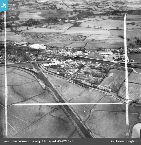
EAW021497 ENGLAND (1949). Henry Venables Ltd Castletown Saw Mill and environs, Stafford, 1949. This image has been produced from a print marked by Aerofilms Ltd for photo editing.
© Copyright OpenStreetMap contributors and licensed by the OpenStreetMap Foundation. 2025. Cartography is licensed as CC BY-SA.
Nearby Images (45)
Details
| Title | [EAW021497] Henry Venables Ltd Castletown Saw Mill and environs, Stafford, 1949. This image has been produced from a print marked by Aerofilms Ltd for photo editing. |
| Reference | EAW021497 |
| Date | 15-March-1949 |
| Link | |
| Place name | STAFFORD |
| Parish | |
| District | |
| Country | ENGLAND |
| Easting / Northing | 391428, 323518 |
| Longitude / Latitude | -2.1271811165475, 52.80881168145 |
| National Grid Reference | SJ914235 |
Pins
Be the first to add a comment to this image!


![[EAW021497] Henry Venables Ltd Castletown Saw Mill and environs, Stafford, 1949. This image has been produced from a print marked by Aerofilms Ltd for photo editing.](http://britainfromabove.org.uk/sites/all/libraries/aerofilms-images/public/100x100/EAW/021/EAW021497.jpg)
![[EAW001872] The Castletown Saw Mills and the Universal Grinding Wheel Works, Stafford, 1946](http://britainfromabove.org.uk/sites/all/libraries/aerofilms-images/public/100x100/EAW/001/EAW001872.jpg)
![[EAW021498] Henry Venables Ltd Castletown Saw Mill alongside the Universal Grinding Wheel Co Ltd Works and environs, Stafford, 1949. This image has been produced from a print marked by Aerofilms Ltd for photo editing.](http://britainfromabove.org.uk/sites/all/libraries/aerofilms-images/public/100x100/EAW/021/EAW021498.jpg)
![[EAW021606] Henry Venables Ltd Castletown Saw Mill alongside the Universal Grinding Wheel Co Ltd Works and environs, Stafford, 1949. This image has been produced from a print marked by Aerofilms Ltd for photo editing.](http://britainfromabove.org.uk/sites/all/libraries/aerofilms-images/public/100x100/EAW/021/EAW021606.jpg)
![[EAW001869] The Castletown Saw Mills and the Universal Grinding Wheel Works, Stafford, 1946](http://britainfromabove.org.uk/sites/all/libraries/aerofilms-images/public/100x100/EAW/001/EAW001869.jpg)
![[EAW001870] The Castletown Saw Mills and the Universal Grinding Wheel Works, Stafford, 1946](http://britainfromabove.org.uk/sites/all/libraries/aerofilms-images/public/100x100/EAW/001/EAW001870.jpg)
![[EAW001868] The Castletown Saw Mills and the Universal Grinding Wheel Works, Stafford, 1946](http://britainfromabove.org.uk/sites/all/libraries/aerofilms-images/public/100x100/EAW/001/EAW001868.jpg)
![[EAW001873] The Castletown Saw Mills and the Universal Grinding Wheel Works, Stafford, 1946](http://britainfromabove.org.uk/sites/all/libraries/aerofilms-images/public/100x100/EAW/001/EAW001873.jpg)
![[EAW021608] Henry Venables Ltd Castletown Saw Mill, Stafford, 1949. This image has been produced from a print marked by Aerofilms Ltd for photo editing.](http://britainfromabove.org.uk/sites/all/libraries/aerofilms-images/public/100x100/EAW/021/EAW021608.jpg)
![[EAW021604] Henry Venables Ltd Castletown Saw Mill, Stafford, 1949. This image has been produced from a print marked by Aerofilms Ltd for photo editing.](http://britainfromabove.org.uk/sites/all/libraries/aerofilms-images/public/100x100/EAW/021/EAW021604.jpg)
![[EAW021603] Henry Venables Ltd Castletown Saw Mill, Stafford, 1949. This image has been produced from a print marked by Aerofilms Ltd for photo editing.](http://britainfromabove.org.uk/sites/all/libraries/aerofilms-images/public/100x100/EAW/021/EAW021603.jpg)
![[EAW021601] Henry Venables Ltd Castletown Saw Mill, Stafford, 1949. This image has been produced from a print marked by Aerofilms Ltd for photo editing.](http://britainfromabove.org.uk/sites/all/libraries/aerofilms-images/public/100x100/EAW/021/EAW021601.jpg)
![[EAW001871] The Castletown Saw Mills and the surrounding area, Stafford, 1946](http://britainfromabove.org.uk/sites/all/libraries/aerofilms-images/public/100x100/EAW/001/EAW001871.jpg)
![[EAW001874] The Castletown Saw Mills and the Universal Grinding Wheel Works, Stafford, 1946](http://britainfromabove.org.uk/sites/all/libraries/aerofilms-images/public/100x100/EAW/001/EAW001874.jpg)
![[EAW021600] Henry Venables Ltd Castletown Saw Mill, Stafford, 1949. This image has been produced from a print marked by Aerofilms Ltd for photo editing.](http://britainfromabove.org.uk/sites/all/libraries/aerofilms-images/public/100x100/EAW/021/EAW021600.jpg)
![[EAW021605] Henry Venables Ltd Castletown Saw Mill alongside the Universal Grinding Wheel Co Ltd Works and environs, Stafford, 1949. This image has been produced from a print marked by Aerofilms Ltd for photo editing.](http://britainfromabove.org.uk/sites/all/libraries/aerofilms-images/public/100x100/EAW/021/EAW021605.jpg)
![[EAW021602] Henry Venables Ltd Castletown Saw Mill, Stafford, 1949. This image has been produced from a print marked by Aerofilms Ltd for photo editing.](http://britainfromabove.org.uk/sites/all/libraries/aerofilms-images/public/100x100/EAW/021/EAW021602.jpg)
![[EAW021607] Henry Venables Ltd Castletown Saw Mill alongside the Universal Grinding Wheel Co Ltd Works and the town, Stafford, from the west, 1949. This image has been produced from a print marked by Aerofilms Ltd for photo editing.](http://britainfromabove.org.uk/sites/all/libraries/aerofilms-images/public/100x100/EAW/021/EAW021607.jpg)
![[EAW000900] The Universal Grinding Wheel Company Ltd, Doxey, 1946](http://britainfromabove.org.uk/sites/all/libraries/aerofilms-images/public/100x100/EAW/000/EAW000900.jpg)
![[EAW000899] The Universal Grinding Wheel Company Ltd, Doxey, 1946](http://britainfromabove.org.uk/sites/all/libraries/aerofilms-images/public/100x100/EAW/000/EAW000899.jpg)
![[EAW000904] The Universal Grinding Wheel Company Ltd, Doxey, from the north-east, 1946](http://britainfromabove.org.uk/sites/all/libraries/aerofilms-images/public/100x100/EAW/000/EAW000904.jpg)
![[EAW000385] The Universal Grinding Wheel Works and the village, Doxey, from the east, 1946. This image has been produced from a damaged negative.](http://britainfromabove.org.uk/sites/all/libraries/aerofilms-images/public/100x100/EAW/000/EAW000385.jpg)
![[EAW000387] The Universal Grinding Wheel Works, Doxey, 1946. This image has been produced from a damaged negative.](http://britainfromabove.org.uk/sites/all/libraries/aerofilms-images/public/100x100/EAW/000/EAW000387.jpg)
![[EAW000388] The Universal Grinding Wheel Works, Doxey, 1946. This image has been produced from a damaged negative.](http://britainfromabove.org.uk/sites/all/libraries/aerofilms-images/public/100x100/EAW/000/EAW000388.jpg)
![[EAW000391] The Universal Grinding Wheel Works, Doxey, 1946. This image has been produced from a damaged negative.](http://britainfromabove.org.uk/sites/all/libraries/aerofilms-images/public/100x100/EAW/000/EAW000391.jpg)
![[EAW021494] Henry Venables Ltd Castletown Saw Mill and environs, Stafford, from the south-east, 1949. This image has been produced from a print marked by Aerofilms Ltd for photo editing.](http://britainfromabove.org.uk/sites/all/libraries/aerofilms-images/public/100x100/EAW/021/EAW021494.jpg)
![[EAW000392] The Universal Grinding Wheel Works and the town of Stafford, Doxey, 1946. This image has been produced from a damaged negative.](http://britainfromabove.org.uk/sites/all/libraries/aerofilms-images/public/100x100/EAW/000/EAW000392.jpg)
![[EAW000386] The Universal Grinding Wheel Works and the village, Doxey, 1946. This image has been produced from a damaged negative.](http://britainfromabove.org.uk/sites/all/libraries/aerofilms-images/public/100x100/EAW/000/EAW000386.jpg)
![[EAW000898] The Universal Grinding Wheel Company Ltd, Doxey, 1946](http://britainfromabove.org.uk/sites/all/libraries/aerofilms-images/public/100x100/EAW/000/EAW000898.jpg)
![[EPW046130] The Universal Grinding Wheel Works and environs, Doxey, from the south-east, 1934](http://britainfromabove.org.uk/sites/all/libraries/aerofilms-images/public/100x100/EPW/046/EPW046130.jpg)
![[EAW021499] Henry Venables Ltd Castletown Saw Mill and environs, Stafford, from the south-east, 1949. This image has been produced from a print marked by Aerofilms Ltd for photo editing.](http://britainfromabove.org.uk/sites/all/libraries/aerofilms-images/public/100x100/EAW/021/EAW021499.jpg)
![[EPW057688] The Universal Grinding Wheel Co Ltd Works on Doxey Road, Doxey, 1938](http://britainfromabove.org.uk/sites/all/libraries/aerofilms-images/public/100x100/EPW/057/EPW057688.jpg)
![[EPW057689] The Universal Grinding Wheel Co Ltd Works on Doxey Road, Doxey, 1938](http://britainfromabove.org.uk/sites/all/libraries/aerofilms-images/public/100x100/EPW/057/EPW057689.jpg)
![[EPW057687] The Universal Grinding Wheel Co Ltd Works on Doxey Road, Doxey, 1938](http://britainfromabove.org.uk/sites/all/libraries/aerofilms-images/public/100x100/EPW/057/EPW057687.jpg)
![[EPW046129] The Universal Grinding Wheel Works and environs, Doxey, from the south-east, 1934. This image has been affected by flare.](http://britainfromabove.org.uk/sites/all/libraries/aerofilms-images/public/100x100/EPW/046/EPW046129.jpg)
![[EPW057691] The Universal Grinding Wheel Co Ltd Works on Doxey Road, Doxey, 1938](http://britainfromabove.org.uk/sites/all/libraries/aerofilms-images/public/100x100/EPW/057/EPW057691.jpg)
![[EPW046125] The Universal Grinding Wheel Works and environs, Doxey, from the south-east, 1934](http://britainfromabove.org.uk/sites/all/libraries/aerofilms-images/public/100x100/EPW/046/EPW046125.jpg)
![[EPW046124] The Universal Grinding Wheel Works and environs, Doxey, from the south-east, 1934](http://britainfromabove.org.uk/sites/all/libraries/aerofilms-images/public/100x100/EPW/046/EPW046124.jpg)
![[EAW000901] The Universal Grinding Wheel Company Ltd, Doxey, 1946](http://britainfromabove.org.uk/sites/all/libraries/aerofilms-images/public/100x100/EAW/000/EAW000901.jpg)
![[EAW000389] The Universal Grinding Wheel Works, Doxey, 1946. This image has been produced from a damaged negative.](http://britainfromabove.org.uk/sites/all/libraries/aerofilms-images/public/100x100/EAW/000/EAW000389.jpg)
![[EAW000903] The Universal Grinding Wheel Company Ltd, Doxey, from the south-east, 1946](http://britainfromabove.org.uk/sites/all/libraries/aerofilms-images/public/100x100/EAW/000/EAW000903.jpg)
![[EPW046128] Burley Terrace, the Universal Grinding Wheel Works and environs, Doxey, from the south-west, 1934](http://britainfromabove.org.uk/sites/all/libraries/aerofilms-images/public/100x100/EPW/046/EPW046128.jpg)
![[EPW046127] Burley Terrace, the Universal Grinding Wheel Works and environs, Doxey, from the south-west, 1934](http://britainfromabove.org.uk/sites/all/libraries/aerofilms-images/public/100x100/EPW/046/EPW046127.jpg)
![[EPW046126] Burley Terrace, the Universal Grinding Wheel Works and environs, Doxey, from the south-west, 1934](http://britainfromabove.org.uk/sites/all/libraries/aerofilms-images/public/100x100/EPW/046/EPW046126.jpg)
![[EAW000390] The Universal Grinding Wheel Works and the surrounding countryside, Doxey, 1946. This image has been produced from a damaged negative.](http://britainfromabove.org.uk/sites/all/libraries/aerofilms-images/public/100x100/EAW/000/EAW000390.jpg)