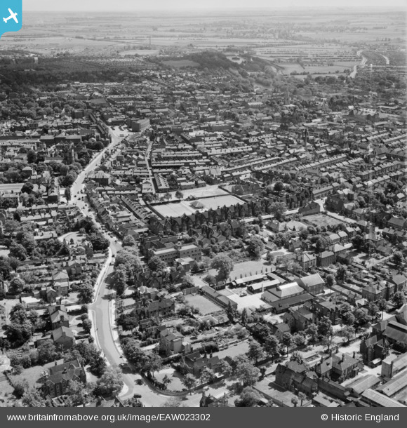
EAW023302 ENGLAND (1949). Bromham Road and the town, Bedford, from the west, 1949
© Copyright OpenStreetMap contributors and licensed by the OpenStreetMap Foundation. 2025. Cartography is licensed as CC BY-SA.
Nearby Images (20)
Details
| Title | [EAW023302] Bromham Road and the town, Bedford, from the west, 1949 |
| Reference | EAW023302 |
| Date | 25-May-1949 |
| Link | |
| Place name | BEDFORD |
| Parish | |
| District | |
| Country | ENGLAND |
| Easting / Northing | 504179, 250050 |
| Longitude / Latitude | -0.47758115016141, 52.138501991746 |
| National Grid Reference | TL042501 |
Pins
 melgibbs |
Wednesday 4th of March 2015 08:57:53 PM | |
 melgibbs |
Saturday 11th of January 2014 07:40:18 PM | |
 melgibbs |
Tuesday 17th of December 2013 09:46:12 PM | |
 melgibbs |
Tuesday 17th of December 2013 09:39:18 PM | |
 melgibbs |
Tuesday 17th of December 2013 09:38:43 PM | |
 melgibbs |
Tuesday 17th of December 2013 09:38:12 PM | |
 melgibbs |
Tuesday 17th of December 2013 09:36:59 PM | |
 melgibbs |
Tuesday 17th of December 2013 09:36:29 PM |


![[EAW023302] Bromham Road and the town, Bedford, from the west, 1949](http://britainfromabove.org.uk/sites/all/libraries/aerofilms-images/public/100x100/EAW/023/EAW023302.jpg)
![[EAW023585] Convent of the Holy Ghost School and environs, Bedford, 1949. This image was marked by Aerofilms Ltd for photo editing.](http://britainfromabove.org.uk/sites/all/libraries/aerofilms-images/public/100x100/EAW/023/EAW023585.jpg)
![[EAW023582] Convent of the Holy Ghost School, Bedford, 1949](http://britainfromabove.org.uk/sites/all/libraries/aerofilms-images/public/100x100/EAW/023/EAW023582.jpg)
![[EAW023586] Convent of the Holy Ghost School, Bedford, 1949. This image was marked by Aerofilms Ltd for photo editing.](http://britainfromabove.org.uk/sites/all/libraries/aerofilms-images/public/100x100/EAW/023/EAW023586.jpg)
![[EAW023303] Convent of the Holy Ghost School and environs, Bedford, 1949. This image was marked by Aerofilms Ltd for photo editing.](http://britainfromabove.org.uk/sites/all/libraries/aerofilms-images/public/100x100/EAW/023/EAW023303.jpg)
![[EAW023583] Conduit Road and the Convent of the Holy Ghost School, Bedford, 1949. This image was marked by Aerofilms Ltd for photo editing.](http://britainfromabove.org.uk/sites/all/libraries/aerofilms-images/public/100x100/EAW/023/EAW023583.jpg)
![[EAW023584] Convent of the Holy Ghost School and environs, Bedford, 1949. This image was marked by Aerofilms Ltd for photo editing.](http://britainfromabove.org.uk/sites/all/libraries/aerofilms-images/public/100x100/EAW/023/EAW023584.jpg)
![[EAW023304] Bromham Road and the Convent of the Holy Ghost School, Bedford, 1949](http://britainfromabove.org.uk/sites/all/libraries/aerofilms-images/public/100x100/EAW/023/EAW023304.jpg)
![[EAW023305] Conduit Road and the Convent of the Holy Ghost School, Bedford, 1949. This image was marked by Aerofilms Ltd for photo editing.](http://britainfromabove.org.uk/sites/all/libraries/aerofilms-images/public/100x100/EAW/023/EAW023305.jpg)
![[EPW046436] Queen's Park and the town, Bedford, from the west, 1934](http://britainfromabove.org.uk/sites/all/libraries/aerofilms-images/public/100x100/EPW/046/EPW046436.jpg)
![[EPW046437] The town, Bedford, from the north-east, 1934](http://britainfromabove.org.uk/sites/all/libraries/aerofilms-images/public/100x100/EPW/046/EPW046437.jpg)
![[EPW026464] Priory Recreation Ground, Bedford, 1929](http://britainfromabove.org.uk/sites/all/libraries/aerofilms-images/public/100x100/EPW/026/EPW026464.jpg)
![[EAW035346] W.H. Allen and Sons Ltd Queen's Engineering Works, Bedford, 1951. This image has been produced from a print marked by Aerofilms Ltd for photo editing.](http://britainfromabove.org.uk/sites/all/libraries/aerofilms-images/public/100x100/EAW/035/EAW035346.jpg)
![[EAW035341] The John P. White and Sons Ltd Pyghtle Works and W.H. Allen and Sons Ltd Queen's Engineering Works, Bedford, 1951. This image has been produced from a print marked by Aerofilms Ltd for photo editing.](http://britainfromabove.org.uk/sites/all/libraries/aerofilms-images/public/100x100/EAW/035/EAW035341.jpg)
![[EAW035342] W.H. Allen and Sons Ltd Queen's Engineering Works, Bedford, 1951. This image has been produced from a print marked by Aerofilms Ltd for photo editing.](http://britainfromabove.org.uk/sites/all/libraries/aerofilms-images/public/100x100/EAW/035/EAW035342.jpg)
![[EAW035340] The John P. White and Sons Ltd Pyghtle Works and W.H. Allen and Sons Ltd Queen's Engineering Works, Bedford, 1951. This image has been produced from a print marked by Aerofilms Ltd for photo editing.](http://britainfromabove.org.uk/sites/all/libraries/aerofilms-images/public/100x100/EAW/035/EAW035340.jpg)
![[EAW035344] W.H. Allen and Sons Ltd Queen's Engineering Works, Bedford, 1951. This image has been produced from a print marked by Aerofilms Ltd for photo editing.](http://britainfromabove.org.uk/sites/all/libraries/aerofilms-images/public/100x100/EAW/035/EAW035344.jpg)
![[EAW035339] The John P. White and Sons Ltd Pyghtle Works and W.H. Allen and Sons Ltd Queen's Engineering Works, Bedford, 1951. This image has been produced from a print marked by Aerofilms Ltd for photo editing.](http://britainfromabove.org.uk/sites/all/libraries/aerofilms-images/public/100x100/EAW/035/EAW035339.jpg)
![[EAW035345] The John P. White and Sons Ltd Pyghtle Works and W.H. Allen and Sons Ltd Queen's Engineering Works, Bedford, 1951. This image has been produced from a print marked by Aerofilms Ltd for photo editing.](http://britainfromabove.org.uk/sites/all/libraries/aerofilms-images/public/100x100/EAW/035/EAW035345.jpg)
![[EAW035343] W.H. Allen and Sons Ltd Queen's Engineering Works off Hurst Grove and environs, Bedford, 1951. This image has been produced from a print marked by Aerofilms Ltd for photo editing.](http://britainfromabove.org.uk/sites/all/libraries/aerofilms-images/public/100x100/EAW/035/EAW035343.jpg)