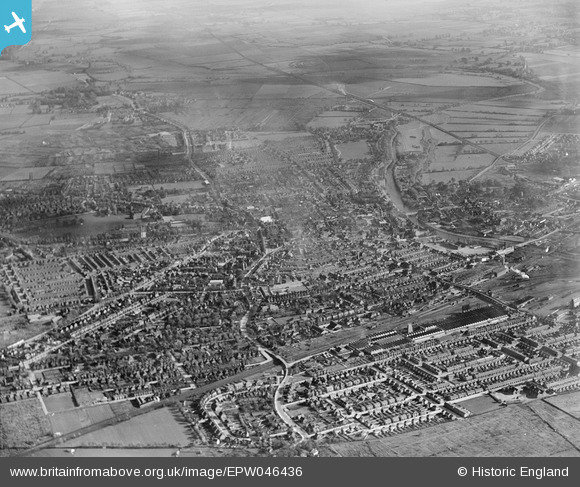
EPW046436 ENGLAND (1934). Queen's Park and the town, Bedford, from the west, 1934
© Copyright OpenStreetMap contributors and licensed by the OpenStreetMap Foundation. 2025. Cartography is licensed as CC BY-SA.
Nearby Images (16)
Details
| Title | [EPW046436] Queen's Park and the town, Bedford, from the west, 1934 |
| Reference | EPW046436 |
| Date | October-1934 |
| Link | |
| Place name | BEDFORD |
| Parish | |
| District | |
| Country | ENGLAND |
| Easting / Northing | 504014, 250071 |
| Longitude / Latitude | -0.47998502997269, 52.138721841912 |
| National Grid Reference | TL040501 |
Pins
 Class31 |
Wednesday 4th of June 2014 10:12:31 AM | |
 melgibbs |
Wednesday 15th of January 2014 06:43:34 PM | |
 melgibbs |
Wednesday 15th of January 2014 06:42:45 PM | |
 melgibbs |
Wednesday 15th of January 2014 06:41:30 PM | |
 melgibbs |
Wednesday 15th of January 2014 06:40:31 PM |


![[EPW046436] Queen's Park and the town, Bedford, from the west, 1934](http://britainfromabove.org.uk/sites/all/libraries/aerofilms-images/public/100x100/EPW/046/EPW046436.jpg)
![[EAW035341] The John P. White and Sons Ltd Pyghtle Works and W.H. Allen and Sons Ltd Queen's Engineering Works, Bedford, 1951. This image has been produced from a print marked by Aerofilms Ltd for photo editing.](http://britainfromabove.org.uk/sites/all/libraries/aerofilms-images/public/100x100/EAW/035/EAW035341.jpg)
![[EAW035348] The John P. White and Sons Ltd Pyghtle Works and W.H. Allen and Sons Ltd Queen's Engineering Works, Bedford, 1951. This image has been produced from a print marked by Aerofilms Ltd for photo editing.](http://britainfromabove.org.uk/sites/all/libraries/aerofilms-images/public/100x100/EAW/035/EAW035348.jpg)
![[EAW035340] The John P. White and Sons Ltd Pyghtle Works and W.H. Allen and Sons Ltd Queen's Engineering Works, Bedford, 1951. This image has been produced from a print marked by Aerofilms Ltd for photo editing.](http://britainfromabove.org.uk/sites/all/libraries/aerofilms-images/public/100x100/EAW/035/EAW035340.jpg)
![[EAW023302] Bromham Road and the town, Bedford, from the west, 1949](http://britainfromabove.org.uk/sites/all/libraries/aerofilms-images/public/100x100/EAW/023/EAW023302.jpg)
![[EAW035347] The John P. White and Sons Ltd Pyghtle Works and W.H. Allen and Sons Ltd Queen's Engineering Works, Bedford, 1951. This image has been produced from a print marked by Aerofilms Ltd for photo editing.](http://britainfromabove.org.uk/sites/all/libraries/aerofilms-images/public/100x100/EAW/035/EAW035347.jpg)
![[EAW035339] The John P. White and Sons Ltd Pyghtle Works and W.H. Allen and Sons Ltd Queen's Engineering Works, Bedford, 1951. This image has been produced from a print marked by Aerofilms Ltd for photo editing.](http://britainfromabove.org.uk/sites/all/libraries/aerofilms-images/public/100x100/EAW/035/EAW035339.jpg)
![[EAW035345] The John P. White and Sons Ltd Pyghtle Works and W.H. Allen and Sons Ltd Queen's Engineering Works, Bedford, 1951. This image has been produced from a print marked by Aerofilms Ltd for photo editing.](http://britainfromabove.org.uk/sites/all/libraries/aerofilms-images/public/100x100/EAW/035/EAW035345.jpg)
![[EAW035346] W.H. Allen and Sons Ltd Queen's Engineering Works, Bedford, 1951. This image has been produced from a print marked by Aerofilms Ltd for photo editing.](http://britainfromabove.org.uk/sites/all/libraries/aerofilms-images/public/100x100/EAW/035/EAW035346.jpg)
![[EAW035342] W.H. Allen and Sons Ltd Queen's Engineering Works, Bedford, 1951. This image has been produced from a print marked by Aerofilms Ltd for photo editing.](http://britainfromabove.org.uk/sites/all/libraries/aerofilms-images/public/100x100/EAW/035/EAW035342.jpg)
![[EAW035344] W.H. Allen and Sons Ltd Queen's Engineering Works, Bedford, 1951. This image has been produced from a print marked by Aerofilms Ltd for photo editing.](http://britainfromabove.org.uk/sites/all/libraries/aerofilms-images/public/100x100/EAW/035/EAW035344.jpg)
![[EAW023585] Convent of the Holy Ghost School and environs, Bedford, 1949. This image was marked by Aerofilms Ltd for photo editing.](http://britainfromabove.org.uk/sites/all/libraries/aerofilms-images/public/100x100/EAW/023/EAW023585.jpg)
![[EPW046430] Queen's Park and the town, Bedford, from the west, 1934](http://britainfromabove.org.uk/sites/all/libraries/aerofilms-images/public/100x100/EPW/046/EPW046430.jpg)
![[EAW023582] Convent of the Holy Ghost School, Bedford, 1949](http://britainfromabove.org.uk/sites/all/libraries/aerofilms-images/public/100x100/EAW/023/EAW023582.jpg)
![[EAW035343] W.H. Allen and Sons Ltd Queen's Engineering Works off Hurst Grove and environs, Bedford, 1951. This image has been produced from a print marked by Aerofilms Ltd for photo editing.](http://britainfromabove.org.uk/sites/all/libraries/aerofilms-images/public/100x100/EAW/035/EAW035343.jpg)
![[EPW046437] The town, Bedford, from the north-east, 1934](http://britainfromabove.org.uk/sites/all/libraries/aerofilms-images/public/100x100/EPW/046/EPW046437.jpg)