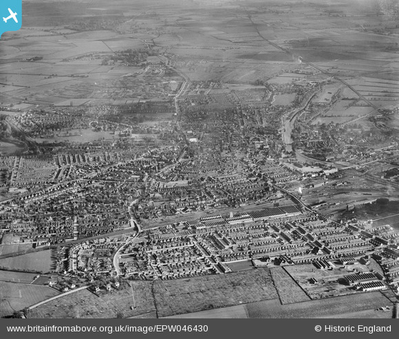
EPW046430 ENGLAND (1934). Queen's Park and the town, Bedford, from the west, 1934
© Copyright OpenStreetMap contributors and licensed by the OpenStreetMap Foundation. 2025. Cartography is licensed as CC BY-SA.
Nearby Images (17)
Details
| Title | [EPW046430] Queen's Park and the town, Bedford, from the west, 1934 |
| Reference | EPW046430 |
| Date | October-1934 |
| Link | |
| Place name | BEDFORD |
| Parish | |
| District | |
| Country | ENGLAND |
| Easting / Northing | 503891, 249863 |
| Longitude / Latitude | -0.48184539075027, 52.136875408582 |
| National Grid Reference | TL039499 |


![[EPW046430] Queen's Park and the town, Bedford, from the west, 1934](http://britainfromabove.org.uk/sites/all/libraries/aerofilms-images/public/100x100/EPW/046/EPW046430.jpg)
![[EAW035345] The John P. White and Sons Ltd Pyghtle Works and W.H. Allen and Sons Ltd Queen's Engineering Works, Bedford, 1951. This image has been produced from a print marked by Aerofilms Ltd for photo editing.](http://britainfromabove.org.uk/sites/all/libraries/aerofilms-images/public/100x100/EAW/035/EAW035345.jpg)
![[EAW035339] The John P. White and Sons Ltd Pyghtle Works and W.H. Allen and Sons Ltd Queen's Engineering Works, Bedford, 1951. This image has been produced from a print marked by Aerofilms Ltd for photo editing.](http://britainfromabove.org.uk/sites/all/libraries/aerofilms-images/public/100x100/EAW/035/EAW035339.jpg)
![[EAW035347] The John P. White and Sons Ltd Pyghtle Works and W.H. Allen and Sons Ltd Queen's Engineering Works, Bedford, 1951. This image has been produced from a print marked by Aerofilms Ltd for photo editing.](http://britainfromabove.org.uk/sites/all/libraries/aerofilms-images/public/100x100/EAW/035/EAW035347.jpg)
![[EAW035343] W.H. Allen and Sons Ltd Queen's Engineering Works off Hurst Grove and environs, Bedford, 1951. This image has been produced from a print marked by Aerofilms Ltd for photo editing.](http://britainfromabove.org.uk/sites/all/libraries/aerofilms-images/public/100x100/EAW/035/EAW035343.jpg)
![[EAW035340] The John P. White and Sons Ltd Pyghtle Works and W.H. Allen and Sons Ltd Queen's Engineering Works, Bedford, 1951. This image has been produced from a print marked by Aerofilms Ltd for photo editing.](http://britainfromabove.org.uk/sites/all/libraries/aerofilms-images/public/100x100/EAW/035/EAW035340.jpg)
![[EAW035348] The John P. White and Sons Ltd Pyghtle Works and W.H. Allen and Sons Ltd Queen's Engineering Works, Bedford, 1951. This image has been produced from a print marked by Aerofilms Ltd for photo editing.](http://britainfromabove.org.uk/sites/all/libraries/aerofilms-images/public/100x100/EAW/035/EAW035348.jpg)
![[EAW035341] The John P. White and Sons Ltd Pyghtle Works and W.H. Allen and Sons Ltd Queen's Engineering Works, Bedford, 1951. This image has been produced from a print marked by Aerofilms Ltd for photo editing.](http://britainfromabove.org.uk/sites/all/libraries/aerofilms-images/public/100x100/EAW/035/EAW035341.jpg)
![[EAW035342] W.H. Allen and Sons Ltd Queen's Engineering Works, Bedford, 1951. This image has been produced from a print marked by Aerofilms Ltd for photo editing.](http://britainfromabove.org.uk/sites/all/libraries/aerofilms-images/public/100x100/EAW/035/EAW035342.jpg)
![[EAW035344] W.H. Allen and Sons Ltd Queen's Engineering Works, Bedford, 1951. This image has been produced from a print marked by Aerofilms Ltd for photo editing.](http://britainfromabove.org.uk/sites/all/libraries/aerofilms-images/public/100x100/EAW/035/EAW035344.jpg)
![[EAW035346] W.H. Allen and Sons Ltd Queen's Engineering Works, Bedford, 1951. This image has been produced from a print marked by Aerofilms Ltd for photo editing.](http://britainfromabove.org.uk/sites/all/libraries/aerofilms-images/public/100x100/EAW/035/EAW035346.jpg)
![[EPW035884] Housing at Queen's Park and the Queen's Engineering Works, Bedford, 1931](http://britainfromabove.org.uk/sites/all/libraries/aerofilms-images/public/100x100/EPW/035/EPW035884.jpg)
![[EPW035883] Housing at Queen's Park, the Queen's Engineering Works and Midland Road Railway Station, Bedford, 1931](http://britainfromabove.org.uk/sites/all/libraries/aerofilms-images/public/100x100/EPW/035/EPW035883.jpg)
![[EPW046436] Queen's Park and the town, Bedford, from the west, 1934](http://britainfromabove.org.uk/sites/all/libraries/aerofilms-images/public/100x100/EPW/046/EPW046436.jpg)
![[EPW035880] Housing off Midland Road, the Queen's Engineering Works and Queen's Park, Bedford, 1931](http://britainfromabove.org.uk/sites/all/libraries/aerofilms-images/public/100x100/EPW/035/EPW035880.jpg)
![[EPW026474] W.H. Allen and Sons Ltd Queen's Engineering Works, Bedford, 1929](http://britainfromabove.org.uk/sites/all/libraries/aerofilms-images/public/100x100/EPW/026/EPW026474.jpg)
![[EPW035885] Housing at Queen's Park, the Queen's Engineering Works and Midland Road Railway Station, Bedford, 1931](http://britainfromabove.org.uk/sites/all/libraries/aerofilms-images/public/100x100/EPW/035/EPW035885.jpg)
