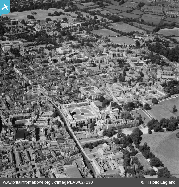
EAW024230 ENGLAND (1949). St Aldate's Street, High Street and environs, Oxford, 1949
© Copyright OpenStreetMap contributors and licensed by the OpenStreetMap Foundation. 2025. Cartography is licensed as CC BY-SA.
Nearby Images (43)
Details
| Title | [EAW024230] St Aldate's Street, High Street and environs, Oxford, 1949 |
| Reference | EAW024230 |
| Date | 27-June-1949 |
| Link | |
| Place name | OXFORD |
| Parish | |
| District | |
| Country | ENGLAND |
| Easting / Northing | 451526, 206132 |
| Longitude / Latitude | -1.2535018481209, 51.751055305091 |
| National Grid Reference | SP515061 |
Pins
 Alan McFaden |
Wednesday 25th of December 2013 11:24:18 AM | |
 Alan McFaden |
Wednesday 25th of December 2013 11:23:50 AM |


![[EAW024230] St Aldate's Street, High Street and environs, Oxford, 1949](http://britainfromabove.org.uk/sites/all/libraries/aerofilms-images/public/100x100/EAW/024/EAW024230.jpg)
![[EAW045712] The city centre, Oxford, 1952. This image has been produced from a print.](http://britainfromabove.org.uk/sites/all/libraries/aerofilms-images/public/100x100/EAW/045/EAW045712.jpg)
![[EPW000826] General view of Christ Church and Radcliffe Camera, Oxford, 1920](http://britainfromabove.org.uk/sites/all/libraries/aerofilms-images/public/100x100/EPW/000/EPW000826.jpg)
![[EAW018723] The city, Oxford, 1948. This image has been produced from a print.](http://britainfromabove.org.uk/sites/all/libraries/aerofilms-images/public/100x100/EAW/018/EAW018723.jpg)
![[EAW014891] The city centre, Oxford, 1948. This image has been produced from a print.](http://britainfromabove.org.uk/sites/all/libraries/aerofilms-images/public/100x100/EAW/014/EAW014891.jpg)
![[EAW018724] The city, Oxford, 1948. This image has been produced from a print.](http://britainfromabove.org.uk/sites/all/libraries/aerofilms-images/public/100x100/EAW/018/EAW018724.jpg)
![[EAW031682] Numerous Colleges and the town centre, Oxford, 1950](http://britainfromabove.org.uk/sites/all/libraries/aerofilms-images/public/100x100/EAW/031/EAW031682.jpg)
![[EAW014893] The city, Oxford, from the south-east, 1948. This image has been produced from a print.](http://britainfromabove.org.uk/sites/all/libraries/aerofilms-images/public/100x100/EAW/014/EAW014893.jpg)
![[EAW013599] The city, Oxford, 1948](http://britainfromabove.org.uk/sites/all/libraries/aerofilms-images/public/100x100/EAW/013/EAW013599.jpg)
![[EPW000849] General view of the Radcliffe Camera and Colleges, Oxford, 1920](http://britainfromabove.org.uk/sites/all/libraries/aerofilms-images/public/100x100/EPW/000/EPW000849.jpg)
![[EAW024229] High Street, St Aldate's Street and the city centre, Oxford, 1949](http://britainfromabove.org.uk/sites/all/libraries/aerofilms-images/public/100x100/EAW/024/EAW024229.jpg)
![[EAW018725] The city, Oxford, 1948. This image has been produced from a print.](http://britainfromabove.org.uk/sites/all/libraries/aerofilms-images/public/100x100/EAW/018/EAW018725.jpg)
![[EAW045713] Christchurch, Oxford, 1952. This image has been produced from a print.](http://britainfromabove.org.uk/sites/all/libraries/aerofilms-images/public/100x100/EAW/045/EAW045713.jpg)
![[EAW049087] University Colleges, Oxford, 1953](http://britainfromabove.org.uk/sites/all/libraries/aerofilms-images/public/100x100/EAW/049/EAW049087.jpg)
![[EPW000832] Christ Church, Oxford, 1920](http://britainfromabove.org.uk/sites/all/libraries/aerofilms-images/public/100x100/EPW/000/EPW000832.jpg)
![[EAW003127] The city, Oxford, from the south, 1946](http://britainfromabove.org.uk/sites/all/libraries/aerofilms-images/public/100x100/EAW/003/EAW003127.jpg)
![[EAW049086] Christ Church, St Aldate's and the city, Oxford, 1953](http://britainfromabove.org.uk/sites/all/libraries/aerofilms-images/public/100x100/EAW/049/EAW049086.jpg)
![[EPW022527] The Radcliffe Camera and environs, Oxford, 1928](http://britainfromabove.org.uk/sites/all/libraries/aerofilms-images/public/100x100/EPW/022/EPW022527.jpg)
![[EPW024627] Christ Church and Oxford Cathedral, Oxford, 1928](http://britainfromabove.org.uk/sites/all/libraries/aerofilms-images/public/100x100/EPW/024/EPW024627.jpg)
![[EPW000838] High Street, Oxford, 1920](http://britainfromabove.org.uk/sites/all/libraries/aerofilms-images/public/100x100/EPW/000/EPW000838.jpg)
![[EPW052775] The Radcliffe Camera and surrounding Colleges, Oxford, 1937](http://britainfromabove.org.uk/sites/all/libraries/aerofilms-images/public/100x100/EPW/052/EPW052775.jpg)
![[EPW052771] The city centre, Oxford, from the south-east, 1937](http://britainfromabove.org.uk/sites/all/libraries/aerofilms-images/public/100x100/EPW/052/EPW052771.jpg)
![[EAW049085] High Street and the city centre, Oxford, 1953](http://britainfromabove.org.uk/sites/all/libraries/aerofilms-images/public/100x100/EAW/049/EAW049085.jpg)
![[EPW022524] The Covered Market and environs, Oxford, 1928](http://britainfromabove.org.uk/sites/all/libraries/aerofilms-images/public/100x100/EPW/022/EPW022524.jpg)
![[EPW000847] High Street, Oxford, 1920](http://britainfromabove.org.uk/sites/all/libraries/aerofilms-images/public/100x100/EPW/000/EPW000847.jpg)
![[EPW052774] The University Colleges and the city centre, Oxford, from the south-west, 1937](http://britainfromabove.org.uk/sites/all/libraries/aerofilms-images/public/100x100/EPW/052/EPW052774.jpg)
![[EAW013598] The city, Oxford, 1948](http://britainfromabove.org.uk/sites/all/libraries/aerofilms-images/public/100x100/EAW/013/EAW013598.jpg)
![[EAW045709] Radcliffe Square and environs, Oxford, 1952. This image has been produced from a print.](http://britainfromabove.org.uk/sites/all/libraries/aerofilms-images/public/100x100/EAW/045/EAW045709.jpg)
![[EAW045706] Carfax and environs, Oxford, 1952. This image has been produced from a print.](http://britainfromabove.org.uk/sites/all/libraries/aerofilms-images/public/100x100/EAW/045/EAW045706.jpg)
![[EAW045705] St Aldate's and environs, Oxford, 1952. This image has been produced from a print.](http://britainfromabove.org.uk/sites/all/libraries/aerofilms-images/public/100x100/EAW/045/EAW045705.jpg)
![[EAW047925] The city in the snow, Oxford, from the south, 1952](http://britainfromabove.org.uk/sites/all/libraries/aerofilms-images/public/100x100/EAW/047/EAW047925.jpg)
![[EPW038408] Christ Church and the city centre, Oxford, 1932](http://britainfromabove.org.uk/sites/all/libraries/aerofilms-images/public/100x100/EPW/038/EPW038408.jpg)
![[EAW018727] The city, Oxford, from the south-east, 1948. This image has been produced from a print.](http://britainfromabove.org.uk/sites/all/libraries/aerofilms-images/public/100x100/EAW/018/EAW018727.jpg)
![[EPW000843] Christ Church area of Oxford, Oxford, 1920](http://britainfromabove.org.uk/sites/all/libraries/aerofilms-images/public/100x100/EPW/000/EPW000843.jpg)
![[EPW017839] St Aldate's Street and the city centre, Oxford, 1927](http://britainfromabove.org.uk/sites/all/libraries/aerofilms-images/public/100x100/EPW/017/EPW017839.jpg)
![[EPW000827] The Radcliffe Camera, Bodleian Library, All Souls College, St Mary's Church and Brasenose College, Oxford, 1920](http://britainfromabove.org.uk/sites/all/libraries/aerofilms-images/public/100x100/EPW/000/EPW000827.jpg)
![[EPW000848] Queen Street and High Street, Oxford,1920](http://britainfromabove.org.uk/sites/all/libraries/aerofilms-images/public/100x100/EPW/000/EPW000848.jpg)
![[EAW003934] Oxford Colleges, the city and Christ Church Meadow in flood, Oxford, from the north, 1947](http://britainfromabove.org.uk/sites/all/libraries/aerofilms-images/public/100x100/EAW/003/EAW003934.jpg)
![[EAW024228] Broad Street, High Street, the Radcliffe Camera and environs, Oxford, 1949](http://britainfromabove.org.uk/sites/all/libraries/aerofilms-images/public/100x100/EAW/024/EAW024228.jpg)
![[EAW049091] The Radcliffe Camera and surrounding colleges, Oxford, 1953](http://britainfromabove.org.uk/sites/all/libraries/aerofilms-images/public/100x100/EAW/049/EAW049091.jpg)
![[EAW003605] The city, Oxford, from the north-east, 1947](http://britainfromabove.org.uk/sites/all/libraries/aerofilms-images/public/100x100/EAW/003/EAW003605.jpg)
![[EPW000829] General view over Oxford showing Christ Church and Radcliffe Camera, Oxford, from the south-west, 1920](http://britainfromabove.org.uk/sites/all/libraries/aerofilms-images/public/100x100/EPW/000/EPW000829.jpg)
![[EPW000845] View over Oxford showing the Radcliffe Camera and Jesus College, Oxford, from the west, 1920](http://britainfromabove.org.uk/sites/all/libraries/aerofilms-images/public/100x100/EPW/000/EPW000845.jpg)

