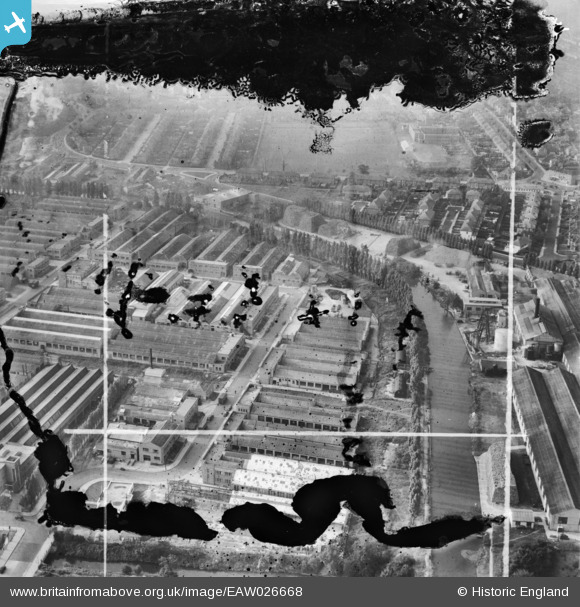
EAW026668 ENGLAND (1949). The Carrier Engineering Co Works, Alperton, 1949. This image has been produced from a damaged negative.
© Copyright OpenStreetMap contributors and licensed by the OpenStreetMap Foundation. 2024. Cartography is licensed as CC BY-SA.
Nearby Images (42)
Details
| Title | [EAW026668] The Carrier Engineering Co Works, Alperton, 1949. This image has been produced from a damaged negative. |
| Reference | EAW026668 |
| Date | 28-September-1949 |
| Link | |
| Place name | ALPERTON |
| Parish | |
| District | |
| Country | ENGLAND |
| Easting / Northing | 518993, 183750 |
| Longitude / Latitude | -0.28400780482256, 51.53961188709 |
| National Grid Reference | TQ190838 |
Pins
 Harrow&Wembley |
Saturday 29th of March 2014 02:09:43 PM |


![[EAW026668] The Carrier Engineering Co Works, Alperton, 1949. This image has been produced from a damaged negative.](http://britainfromabove.org.uk/sites/all/libraries/aerofilms-images/public/100x100/EAW/026/EAW026668.jpg)
![[EAW026666] The Carrier Engineering Co Works, Alperton, 1949. This image has been produced from a damaged negative.](http://britainfromabove.org.uk/sites/all/libraries/aerofilms-images/public/100x100/EAW/026/EAW026666.jpg)
![[EAW026664] The Carrier Engineering Co Works and the surrounding residential area, Alperton, 1949. This image has been produced from a damaged negative.](http://britainfromabove.org.uk/sites/all/libraries/aerofilms-images/public/100x100/EAW/026/EAW026664.jpg)
![[EAW026662] The Carrier Engineering Co Works, Alperton, 1949. This image was marked by Aerofilms Ltd for photo editing.](http://britainfromabove.org.uk/sites/all/libraries/aerofilms-images/public/100x100/EAW/026/EAW026662.jpg)
![[EAW026665] The Carrier Engineering Co Works, Alperton, 1949. This image has been produced from a damaged negative.](http://britainfromabove.org.uk/sites/all/libraries/aerofilms-images/public/100x100/EAW/026/EAW026665.jpg)
![[EPW056419] Celotex Ltd Works on the Grand Union Canal (Paddington Branch), Alperton, 1938](http://britainfromabove.org.uk/sites/all/libraries/aerofilms-images/public/100x100/EPW/056/EPW056419.jpg)
![[EPW056420] Celotex Ltd Works on the Grand Union Canal (Paddington Branch), Alperton, 1938](http://britainfromabove.org.uk/sites/all/libraries/aerofilms-images/public/100x100/EPW/056/EPW056420.jpg)
![[EPW056466] The Celotex Ltd factory, the Grand Union Canal and environs at Stonebridge Park, Alperton, 1938](http://britainfromabove.org.uk/sites/all/libraries/aerofilms-images/public/100x100/EPW/056/EPW056466.jpg)
![[EAW026663] The Carrier Engineering Co Works and the surrounding residential area, Alperton, 1949. This image has been produced from a damaged negative.](http://britainfromabove.org.uk/sites/all/libraries/aerofilms-images/public/100x100/EAW/026/EAW026663.jpg)
![[EPW056414] Celotex Ltd Works on the Grand Union Canal (Paddington Branch), Alperton, 1938](http://britainfromabove.org.uk/sites/all/libraries/aerofilms-images/public/100x100/EPW/056/EPW056414.jpg)
![[EPW056416] Celotex Ltd Works on the Grand Union Canal (Paddington Branch), Alperton, 1938](http://britainfromabove.org.uk/sites/all/libraries/aerofilms-images/public/100x100/EPW/056/EPW056416.jpg)
![[EPW056418] Celotex Ltd Works on the Grand Union Canal (Paddington Branch), Alperton, 1938. This image has been affected by flare.](http://britainfromabove.org.uk/sites/all/libraries/aerofilms-images/public/100x100/EPW/056/EPW056418.jpg)
![[EPW056462] The Celotex Ltd factory, the Grand Union Canal and environs at Stonebridge Park, Alperton, 1938](http://britainfromabove.org.uk/sites/all/libraries/aerofilms-images/public/100x100/EPW/056/EPW056462.jpg)
![[EPW056757] The Celotex Ltd Works alongside the Grand Union Canal, Alperton, 1938](http://britainfromabove.org.uk/sites/all/libraries/aerofilms-images/public/100x100/EPW/056/EPW056757.jpg)
![[EPW056417] Celotex Ltd Works on the Grand Union Canal (Paddington Branch), Alperton, 1938](http://britainfromabove.org.uk/sites/all/libraries/aerofilms-images/public/100x100/EPW/056/EPW056417.jpg)
![[EAW026667] The Carrier Engineering Co Works, Alperton, 1949. This image has been produced from a damaged negative.](http://britainfromabove.org.uk/sites/all/libraries/aerofilms-images/public/100x100/EAW/026/EAW026667.jpg)
![[EPW056460] The Celotex Ltd factory at Stonebridge Park, Alperton, 1938](http://britainfromabove.org.uk/sites/all/libraries/aerofilms-images/public/100x100/EPW/056/EPW056460.jpg)
![[EPW056461] The Celotex Ltd factory, the Grand Union Canal and environs at Stonebridge Park, Alperton, 1938](http://britainfromabove.org.uk/sites/all/libraries/aerofilms-images/public/100x100/EPW/056/EPW056461.jpg)
![[EPW056760] The Celotex Ltd Works alongside the Grand Union Canal, Alperton, 1938](http://britainfromabove.org.uk/sites/all/libraries/aerofilms-images/public/100x100/EPW/056/EPW056760.jpg)
![[EPW056762] The Celotex Ltd Works alongside the Grand Union Canal, Alperton, 1938](http://britainfromabove.org.uk/sites/all/libraries/aerofilms-images/public/100x100/EPW/056/EPW056762.jpg)
![[EPW056759] The Celotex Ltd Works alongside the Grand Union Canal, Alperton, 1938](http://britainfromabove.org.uk/sites/all/libraries/aerofilms-images/public/100x100/EPW/056/EPW056759.jpg)
![[EPW056415] Celotex Ltd Works on the Grand Union Canal (Paddington Branch), Alperton, 1938](http://britainfromabove.org.uk/sites/all/libraries/aerofilms-images/public/100x100/EPW/056/EPW056415.jpg)
![[EPW056465] The Celotex Ltd factory and the Grand Union Canal at Stonebridge Park, Alperton, 1938](http://britainfromabove.org.uk/sites/all/libraries/aerofilms-images/public/100x100/EPW/056/EPW056465.jpg)
![[EPW056761] The Celotex Ltd Works alongside the Grand Union Canal, Alperton, 1938](http://britainfromabove.org.uk/sites/all/libraries/aerofilms-images/public/100x100/EPW/056/EPW056761.jpg)
![[EPW056463] The Celotex Ltd factory and the Grand Union Canal at Stonebridge Park, Alperton, 1938](http://britainfromabove.org.uk/sites/all/libraries/aerofilms-images/public/100x100/EPW/056/EPW056463.jpg)
![[EPW056758] The Celotex Ltd Works alongside the Grand Union Canal, Alperton, 1938](http://britainfromabove.org.uk/sites/all/libraries/aerofilms-images/public/100x100/EPW/056/EPW056758.jpg)
![[EPW056763] The Celotex Ltd Works alongside the Grand Union Canal, Alperton, 1938](http://britainfromabove.org.uk/sites/all/libraries/aerofilms-images/public/100x100/EPW/056/EPW056763.jpg)
![[EPW056464] The Celotex Ltd factory and environs at Stonebridge Park, Alperton, 1938](http://britainfromabove.org.uk/sites/all/libraries/aerofilms-images/public/100x100/EPW/056/EPW056464.jpg)
![[EAW017043] The Scottish Dyeing & Cleaning Works on Abbeydale Road and surrounding businesses, Alperton, 1948. This image was marked by Aerofilms Ltd for photo editing.](http://britainfromabove.org.uk/sites/all/libraries/aerofilms-images/public/100x100/EAW/017/EAW017043.jpg)
![[EAW017038] The Scottish Dyeing & Cleaning Works on Abbeydale Road and surrounding businesses, Alperton, 1948. This image was marked by Aerofilms Ltd for photo editing.](http://britainfromabove.org.uk/sites/all/libraries/aerofilms-images/public/100x100/EAW/017/EAW017038.jpg)
![[EAW017037] The Scottish Dyeing & Cleaning Works on Abbeydale Road and surrounding businesses, Alperton, 1948. This image was marked by Aerofilms Ltd for photo editing.](http://britainfromabove.org.uk/sites/all/libraries/aerofilms-images/public/100x100/EAW/017/EAW017037.jpg)
![[EAW017044] The Scottish Dyeing & Cleaning Works on Abbeydale Road and surrounding businesses, Alperton, 1948. This image was marked by Aerofilms Ltd for photo editing.](http://britainfromabove.org.uk/sites/all/libraries/aerofilms-images/public/100x100/EAW/017/EAW017044.jpg)
![[EAW017040] The Scottish Dyeing & Cleaning Works on Abbeydale Road and surrounding businesses, Alperton, 1948. This image was marked by Aerofilms Ltd for photo editing.](http://britainfromabove.org.uk/sites/all/libraries/aerofilms-images/public/100x100/EAW/017/EAW017040.jpg)
![[EAW017042] The Scottish Dyeing & Cleaning Works on Abbeydale Road and surrounding businesses, Alperton, 1948. This image was marked by Aerofilms Ltd for photo editing.](http://britainfromabove.org.uk/sites/all/libraries/aerofilms-images/public/100x100/EAW/017/EAW017042.jpg)
![[EAW017045] The Scottish Dyeing & Cleaning Works on Abbeydale Road and surrounding businesses, Alperton, 1948. This image was marked by Aerofilms Ltd for photo editing.](http://britainfromabove.org.uk/sites/all/libraries/aerofilms-images/public/100x100/EAW/017/EAW017045.jpg)
![[EPW051673] Construction of Beresford Avenue and housing at Kenmere Gardens and environs, Alperton, 1936. This image was marked by Aerofilms Ltd for photo editing.](http://britainfromabove.org.uk/sites/all/libraries/aerofilms-images/public/100x100/EPW/051/EPW051673.jpg)
![[EAW017041] The Scottish Dyeing & Cleaning Works on Abbeydale Road and surrounding businesses, Alperton, 1948. This image was marked by Aerofilms Ltd for photo editing.](http://britainfromabove.org.uk/sites/all/libraries/aerofilms-images/public/100x100/EAW/017/EAW017041.jpg)
![[EPW053020] Construction of housing and industrial buildings along Beresford Avenue and environs, Alperton, 1937](http://britainfromabove.org.uk/sites/all/libraries/aerofilms-images/public/100x100/EPW/053/EPW053020.jpg)
![[EPW052478] Industrial units under construction on Water Road, Alperton, 1937](http://britainfromabove.org.uk/sites/all/libraries/aerofilms-images/public/100x100/EPW/052/EPW052478.jpg)
![[EPW051680] Brent Junction, construction of Beresford Avenue and environs, Alperton, 1936](http://britainfromabove.org.uk/sites/all/libraries/aerofilms-images/public/100x100/EPW/051/EPW051680.jpg)
![[EPW056088] The Celotex Works under construction, Alperton, 1937. This image has been produced from a damaged negative.](http://britainfromabove.org.uk/sites/all/libraries/aerofilms-images/public/100x100/EPW/056/EPW056088.jpg)
![[EPW056086] The Celotex Works under construction, Alperton, 1937. This image has been produced from a damaged negative.](http://britainfromabove.org.uk/sites/all/libraries/aerofilms-images/public/100x100/EPW/056/EPW056086.jpg)