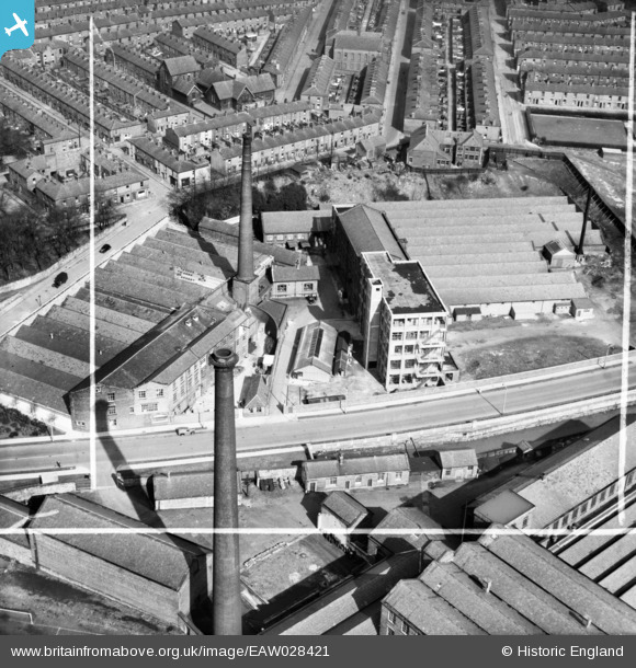
EAW028421 ENGLAND (1950). Witton Mill, Stancliffe Mill and environs, Blackburn, 1950. This image was marked by Aerofilms Ltd for photo editing.
© Copyright OpenStreetMap contributors and licensed by the OpenStreetMap Foundation. 2025. Cartography is licensed as CC BY-SA.
Nearby Images (10)
Details
| Title | [EAW028421] Witton Mill, Stancliffe Mill and environs, Blackburn, 1950. This image was marked by Aerofilms Ltd for photo editing. |
| Reference | EAW028421 |
| Date | 24-March-1950 |
| Link | |
| Place name | BLACKBURN |
| Parish | |
| District | |
| Country | ENGLAND |
| Easting / Northing | 367044, 427084 |
| Longitude / Latitude | -2.4996932065319, 53.738876087062 |
| National Grid Reference | SD670271 |
Pins
Be the first to add a comment to this image!


![[EAW028421] Witton Mill, Stancliffe Mill and environs, Blackburn, 1950. This image was marked by Aerofilms Ltd for photo editing.](http://britainfromabove.org.uk/sites/all/libraries/aerofilms-images/public/100x100/EAW/028/EAW028421.jpg)
![[EAW028420] Witton Mill, Stancliffe Mill, Stancliffe Street and environs, Blackburn, 1950](http://britainfromabove.org.uk/sites/all/libraries/aerofilms-images/public/100x100/EAW/028/EAW028420.jpg)
![[EAW028427] Witton Mill and Stancliffe Mill, Blackburn, 1950. This image was marked by Aerofilms Ltd for photo editing.](http://britainfromabove.org.uk/sites/all/libraries/aerofilms-images/public/100x100/EAW/028/EAW028427.jpg)
![[EAW028424] Witton Mill and Stancliffe Mill, Blackburn, 1950. This image was marked by Aerofilms Ltd for photo editing.](http://britainfromabove.org.uk/sites/all/libraries/aerofilms-images/public/100x100/EAW/028/EAW028424.jpg)
![[EAW028422] Witton Mill, Stancliffe Mill, Griffin Mill and environs, Blackburn, 1950. This image was marked by Aerofilms Ltd for photo editing.](http://britainfromabove.org.uk/sites/all/libraries/aerofilms-images/public/100x100/EAW/028/EAW028422.jpg)
![[EAW028423] Witton Mill, Stancliffe Mill and Stancliffe Street, Blackburn, 1950. This image was marked by Aerofilms Ltd for photo editing.](http://britainfromabove.org.uk/sites/all/libraries/aerofilms-images/public/100x100/EAW/028/EAW028423.jpg)
![[EPW013923] The Griffin Mills, Witton Mill and Stancliffe Mill, Blackburn, 1925](http://britainfromabove.org.uk/sites/all/libraries/aerofilms-images/public/100x100/EPW/013/EPW013923.jpg)
![[EAW028419] Witton Mill, Stancliffe Mill and environs, Blackburn, 1950. This image was marked by Aerofilms Ltd for photo editing.](http://britainfromabove.org.uk/sites/all/libraries/aerofilms-images/public/100x100/EAW/028/EAW028419.jpg)
![[EAW028425] Witton Mill, Stancliffe Mill and environs, Blackburn, 1950. This image was marked by Aerofilms Ltd for photo editing.](http://britainfromabove.org.uk/sites/all/libraries/aerofilms-images/public/100x100/EAW/028/EAW028425.jpg)
![[EAW028426] Witton Mill, Stancliffe Mill and Stancliffe Street, Blackburn, 1950. This image was marked by Aerofilms Ltd for photo editing.](http://britainfromabove.org.uk/sites/all/libraries/aerofilms-images/public/100x100/EAW/028/EAW028426.jpg)