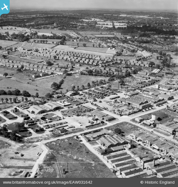
EAW031642 ENGLAND (1950). John Laing and Son Ltd Depot off Chester Road and environs, Borehamwood, from the north-east, 1950
© Copyright OpenStreetMap contributors and licensed by the OpenStreetMap Foundation. 2025. Cartography is licensed as CC BY-SA.
Nearby Images (34)
Details
| Title | [EAW031642] John Laing and Son Ltd Depot off Chester Road and environs, Borehamwood, from the north-east, 1950 |
| Reference | EAW031642 |
| Date | 1-August-1950 |
| Link | |
| Place name | BOREHAMWOOD |
| Parish | ELSTREE AND BOREHAMWOOD |
| District | |
| Country | ENGLAND |
| Easting / Northing | 520770, 196812 |
| Longitude / Latitude | -0.25389662839362, 51.656638107862 |
| National Grid Reference | TQ208968 |
Pins
Be the first to add a comment to this image!


![[EAW031642] John Laing and Son Ltd Depot off Chester Road and environs, Borehamwood, from the north-east, 1950](http://britainfromabove.org.uk/sites/all/libraries/aerofilms-images/public/100x100/EAW/031/EAW031642.jpg)
![[EAW031644] John Laing and Son Ltd Depot off Chester Road and environs, Borehamwood, from the north-east, 1950](http://britainfromabove.org.uk/sites/all/libraries/aerofilms-images/public/100x100/EAW/031/EAW031644.jpg)
![[EAW031638] John Laing and Son Ltd Depot off Chester Road, Borehamwood, 1950](http://britainfromabove.org.uk/sites/all/libraries/aerofilms-images/public/100x100/EAW/031/EAW031638.jpg)
![[EAW031634] John Laing and Son Ltd Depot off Chester Road, Borehamwood, 1950](http://britainfromabove.org.uk/sites/all/libraries/aerofilms-images/public/100x100/EAW/031/EAW031634.jpg)
![[EAW044305] New housing under construction to the south of Elstree Way, Borehamwood, from the north-east, 1952](http://britainfromabove.org.uk/sites/all/libraries/aerofilms-images/public/100x100/EAW/044/EAW044305.jpg)
![[EAW031643] John Laing and Son Ltd Depot off Chester Road, Borehamwood, 1950](http://britainfromabove.org.uk/sites/all/libraries/aerofilms-images/public/100x100/EAW/031/EAW031643.jpg)
![[EAW031635] John Laing and Son Ltd Depot off Chester Road, Borehamwood, 1950](http://britainfromabove.org.uk/sites/all/libraries/aerofilms-images/public/100x100/EAW/031/EAW031635.jpg)
![[EAW031636] John Laing and Son Ltd Depot off Chester Road, Borehamwood, 1950](http://britainfromabove.org.uk/sites/all/libraries/aerofilms-images/public/100x100/EAW/031/EAW031636.jpg)
![[EAW044306] New housing under construction to the south of Elstree Way, Borehamwood, from the north, 1952](http://britainfromabove.org.uk/sites/all/libraries/aerofilms-images/public/100x100/EAW/044/EAW044306.jpg)
![[EAW031639] John Laing and Son Ltd Depot off Chester Road, Borehamwood, 1950](http://britainfromabove.org.uk/sites/all/libraries/aerofilms-images/public/100x100/EAW/031/EAW031639.jpg)
![[EAW031633] John Laing and Son Ltd Depot off Chester Road, Borehamwood, 1950](http://britainfromabove.org.uk/sites/all/libraries/aerofilms-images/public/100x100/EAW/031/EAW031633.jpg)
![[EAW031637] John Laing and Son Ltd Depot off Chester Road and environs, Borehamwood, 1950](http://britainfromabove.org.uk/sites/all/libraries/aerofilms-images/public/100x100/EAW/031/EAW031637.jpg)
![[EAW044446] Houses under construction along Newark Green and industrial premises on Elstree Way, Borehamwood, 1952](http://britainfromabove.org.uk/sites/all/libraries/aerofilms-images/public/100x100/EAW/044/EAW044446.jpg)
![[EAW031641] John Laing and Son Ltd Depot off Chester Road, Borehamwood, 1950](http://britainfromabove.org.uk/sites/all/libraries/aerofilms-images/public/100x100/EAW/031/EAW031641.jpg)
![[EAW031640] John Laing and Son Ltd Depot off Chester Road and Featherstone Gardens, Borehamwood, 1950](http://britainfromabove.org.uk/sites/all/libraries/aerofilms-images/public/100x100/EAW/031/EAW031640.jpg)
![[EAW044447] The Thatched Barn roadhouse and industrial premises between Elstree Way and Chester Road, Borehamwood, 1952](http://britainfromabove.org.uk/sites/all/libraries/aerofilms-images/public/100x100/EAW/044/EAW044447.jpg)
![[EAW045742] Factories and depot between Chester Road and King George's Field, Borehamwood, 1952](http://britainfromabove.org.uk/sites/all/libraries/aerofilms-images/public/100x100/EAW/045/EAW045742.jpg)
![[EAW045740] Factories and depot between Chester Road and King George's Field, Borehamwood, 1952](http://britainfromabove.org.uk/sites/all/libraries/aerofilms-images/public/100x100/EAW/045/EAW045740.jpg)
![[EAW044445] The Thatched Barn roadhouse and industrial premises on Elstree Way, Borehamwood, 1952](http://britainfromabove.org.uk/sites/all/libraries/aerofilms-images/public/100x100/EAW/044/EAW044445.jpg)
![[EAW013430] An experimental colour image of the MGM Film Studios on Elstree Way, Borehamwood, from the south, 1948](http://britainfromabove.org.uk/sites/all/libraries/aerofilms-images/public/100x100/EAW/013/EAW013430.jpg)
![[EAW012434] Aerofilms Ltd offices at 6 Elstree Way and environs, Borehamwood, 1947](http://britainfromabove.org.uk/sites/all/libraries/aerofilms-images/public/100x100/EAW/012/EAW012434.jpg)
![[EAW043031] Hunting Aerosurveys Ltd Offices at 6 Elstree Way, Borehamwood, 1952](http://britainfromabove.org.uk/sites/all/libraries/aerofilms-images/public/100x100/EAW/043/EAW043031.jpg)
![[EAW012436] Aerofilms Ltd offices at 6 Elstree Way, Borehamwood, 1947](http://britainfromabove.org.uk/sites/all/libraries/aerofilms-images/public/100x100/EAW/012/EAW012436.jpg)
![[EAW011794] Huntings Surveys Limited, Borehamwood, 1947](http://britainfromabove.org.uk/sites/all/libraries/aerofilms-images/public/100x100/EAW/011/EAW011794.jpg)
![[EAW043030] Hunting Aerosurveys Ltd Offices at 6 Elstree Way, Borehamwood, 1952](http://britainfromabove.org.uk/sites/all/libraries/aerofilms-images/public/100x100/EAW/043/EAW043030.jpg)
![[EAW043027] Hunting Aerosurveys Ltd Offices at 6 Elstree Way, Borehamwood, 1952](http://britainfromabove.org.uk/sites/all/libraries/aerofilms-images/public/100x100/EAW/043/EAW043027.jpg)
![[EAW011795] Huntings Surveys Limited, Borehamwood, 1947](http://britainfromabove.org.uk/sites/all/libraries/aerofilms-images/public/100x100/EAW/011/EAW011795.jpg)
![[EAW012439] Aerofilms Ltd offices at 6 Elstree Way, Borehamwood, 1947. This image has been produced from a damaged negative.](http://britainfromabove.org.uk/sites/all/libraries/aerofilms-images/public/100x100/EAW/012/EAW012439.jpg)
![[EAW012442] Aerofilms Ltd offices at 6 Elstree Way, Borehamwood, 1947](http://britainfromabove.org.uk/sites/all/libraries/aerofilms-images/public/100x100/EAW/012/EAW012442.jpg)
![[EAW043029] Hunting Aerosurveys Ltd Offices at 6 Elstree Way, Borehamwood, 1952](http://britainfromabove.org.uk/sites/all/libraries/aerofilms-images/public/100x100/EAW/043/EAW043029.jpg)
![[EAW043032] Hunting Aerosurveys Ltd Offices at 6 Elstree Way, Borehamwood, 1952](http://britainfromabove.org.uk/sites/all/libraries/aerofilms-images/public/100x100/EAW/043/EAW043032.jpg)
![[EAW043028] Hunting Aerosurveys Ltd Offices at 6 Elstree Way, Borehamwood, 1952](http://britainfromabove.org.uk/sites/all/libraries/aerofilms-images/public/100x100/EAW/043/EAW043028.jpg)
![[EAW012437] Aerofilms Ltd offices at 6 Elstree Way, Borehamwood, 1947](http://britainfromabove.org.uk/sites/all/libraries/aerofilms-images/public/100x100/EAW/012/EAW012437.jpg)
![[EAW044451] Industrial premises on Elstree Way, Borehamwood, 1952](http://britainfromabove.org.uk/sites/all/libraries/aerofilms-images/public/100x100/EAW/044/EAW044451.jpg)