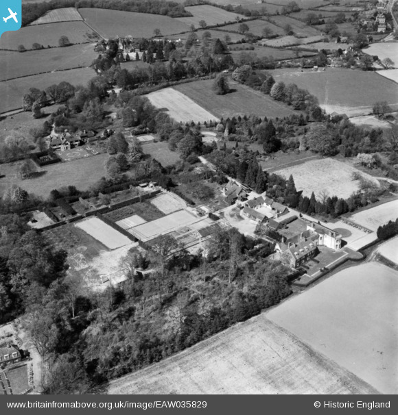
EAW035829 ENGLAND (1951). Landhurst, Hartfield, 1951. This image has been produced from a print.
© Copyright OpenStreetMap contributors and licensed by the OpenStreetMap Foundation. 2025. Cartography is licensed as CC BY-SA.
Nearby Images (13)
Details
| Title | [EAW035829] Landhurst, Hartfield, 1951. This image has been produced from a print. |
| Reference | EAW035829 |
| Date | 12-May-1951 |
| Link | |
| Place name | HARTFIELD |
| Parish | HARTFIELD |
| District | |
| Country | ENGLAND |
| Easting / Northing | 547309, 134882 |
| Longitude / Latitude | 0.10387210119036, 51.093771366933 |
| National Grid Reference | TQ473349 |
Pins
Be the first to add a comment to this image!


![[EAW035829] Landhurst, Hartfield, 1951. This image has been produced from a print.](http://britainfromabove.org.uk/sites/all/libraries/aerofilms-images/public/100x100/EAW/035/EAW035829.jpg)
![[EAW036349] Landhurst at Gallipot Street, Hartfield, 1951. This image has been produced from a print marked by Aerofilms Ltd for photo editing.](http://britainfromabove.org.uk/sites/all/libraries/aerofilms-images/public/100x100/EAW/036/EAW036349.jpg)
![[EAW035826] Landhurst, Hartfield, 1951. This image has been produced from a print marked by Aerofilms Ltd for photo editing.](http://britainfromabove.org.uk/sites/all/libraries/aerofilms-images/public/100x100/EAW/035/EAW035826.jpg)
![[EAW035827] Landhurst and the surrounding countryside, Hartfield, 1951. This image has been produced from a print.](http://britainfromabove.org.uk/sites/all/libraries/aerofilms-images/public/100x100/EAW/035/EAW035827.jpg)
![[EAW036350] Landhurst at Gallipot Street, Hartfield, 1951. This image has been produced from a print marked by Aerofilms Ltd for photo editing.](http://britainfromabove.org.uk/sites/all/libraries/aerofilms-images/public/100x100/EAW/036/EAW036350.jpg)
![[EAW036348] Landhurst at Gallipot Street, Hartfield, 1951. This image has been produced from a print marked by Aerofilms Ltd for photo editing.](http://britainfromabove.org.uk/sites/all/libraries/aerofilms-images/public/100x100/EAW/036/EAW036348.jpg)
![[EAW035830] Landhurst, Hartfield, 1951. This image has been produced from a print marked by Aerofilms Ltd for photo editing.](http://britainfromabove.org.uk/sites/all/libraries/aerofilms-images/public/100x100/EAW/035/EAW035830.jpg)
![[EAW036345] Landhurst at Gallipot Street, Hartfield, 1951. This image has been produced from a print marked by Aerofilms Ltd for photo editing.](http://britainfromabove.org.uk/sites/all/libraries/aerofilms-images/public/100x100/EAW/036/EAW036345.jpg)
![[EAW036346] Landhurst at Gallipot Street, Hartfield, 1951. This image has been produced from a print marked by Aerofilms Ltd for photo editing.](http://britainfromabove.org.uk/sites/all/libraries/aerofilms-images/public/100x100/EAW/036/EAW036346.jpg)
![[EAW036347] Landhurst at Gallipot Street, Hartfield, 1951. This image has been produced from a print marked by Aerofilms Ltd for photo editing.](http://britainfromabove.org.uk/sites/all/libraries/aerofilms-images/public/100x100/EAW/036/EAW036347.jpg)
![[EAW036352] Landhurst at Gallipot Street, Hartfield, 1951. This image has been produced from a print marked by Aerofilms Ltd for photo editing.](http://britainfromabove.org.uk/sites/all/libraries/aerofilms-images/public/100x100/EAW/036/EAW036352.jpg)
![[EAW036351] Landhurst at Gallipot Street, Hartfield, 1951. This image has been produced from a print marked by Aerofilms Ltd for photo editing.](http://britainfromabove.org.uk/sites/all/libraries/aerofilms-images/public/100x100/EAW/036/EAW036351.jpg)
![[EAW035828] Landhurst and the surrounding area, Hartfield, 1951. This image has been produced from a print.](http://britainfromabove.org.uk/sites/all/libraries/aerofilms-images/public/100x100/EAW/035/EAW035828.jpg)