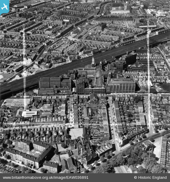
EAW036891 ENGLAND (1951). Peek, Frean and Co Ltd Biscuit Works and environs, Bermondsey, 1951. This image has been produced from a print marked by Aerofilms Ltd for photo editing.
© Copyright OpenStreetMap contributors and licensed by the OpenStreetMap Foundation. 2025. Cartography is licensed as CC BY-SA.
Nearby Images (25)
Details
| Title | [EAW036891] Peek, Frean and Co Ltd Biscuit Works and environs, Bermondsey, 1951. This image has been produced from a print marked by Aerofilms Ltd for photo editing. |
| Reference | EAW036891 |
| Date | 6-June-1951 |
| Link | |
| Place name | BERMONDSEY |
| Parish | |
| District | |
| Country | ENGLAND |
| Easting / Northing | 534708, 178980 |
| Longitude / Latitude | -0.059337763680329, 51.493210232335 |
| National Grid Reference | TQ347790 |
Pins
 Leslie B |
Monday 2nd of April 2018 03:12:27 PM |


![[EAW036891] Peek, Frean and Co Ltd Biscuit Works and environs, Bermondsey, 1951. This image has been produced from a print marked by Aerofilms Ltd for photo editing.](http://britainfromabove.org.uk/sites/all/libraries/aerofilms-images/public/100x100/EAW/036/EAW036891.jpg)
![[EAW036890] Peek, Frean and Co Ltd Biscuit Works and environs, Bermondsey, 1951. This image has been produced from a print marked by Aerofilms Ltd for photo editing.](http://britainfromabove.org.uk/sites/all/libraries/aerofilms-images/public/100x100/EAW/036/EAW036890.jpg)
![[EAW036889] Peek, Frean and Co Ltd Biscuit Works and environs, Bermondsey, 1951. This image has been produced from a print marked by Aerofilms Ltd for photo editing.](http://britainfromabove.org.uk/sites/all/libraries/aerofilms-images/public/100x100/EAW/036/EAW036889.jpg)
![[EAW034839] The Peek, Frean & Co Ltd Biscuit Works, adjacent railway overpass and environs, Bermondsey, 1951. This image has been produced from a print marked by Aerofilms Ltd for photo editing.](http://britainfromabove.org.uk/sites/all/libraries/aerofilms-images/public/100x100/EAW/034/EAW034839.jpg)
![[EAW036895] Peek, Frean and Co Ltd Biscuit Works and environs, Bermondsey, 1951. This image has been produced from a print marked by Aerofilms Ltd for photo editing.](http://britainfromabove.org.uk/sites/all/libraries/aerofilms-images/public/100x100/EAW/036/EAW036895.jpg)
![[EAW034838] The Peek, Frean & Co Ltd Biscuit Works, adjacent railway overpass and environs, Bermondsey, 1951. This image has been produced from a print marked by Aerofilms Ltd for photo editing.](http://britainfromabove.org.uk/sites/all/libraries/aerofilms-images/public/100x100/EAW/034/EAW034838.jpg)
![[EAW034836] The Peek, Frean & Co Ltd Biscuit Works, adjacent railway overpass and environs, Bermondsey, 1951. This image has been produced from a print marked by Aerofilms Ltd for photo editing.](http://britainfromabove.org.uk/sites/all/libraries/aerofilms-images/public/100x100/EAW/034/EAW034836.jpg)
![[EAW034843] The Peek, Frean & Co Ltd Biscuit Works, adjacent railway overpass and environs, Bermondsey, 1951. This image has been produced from a print marked by Aerofilms Ltd for photo editing.](http://britainfromabove.org.uk/sites/all/libraries/aerofilms-images/public/100x100/EAW/034/EAW034843.jpg)
![[EAW034840] The Peek, Frean & Co Ltd Biscuit Works looking towards Southwark Park, Bermondsey, 1951. This image has been produced from a print marked by Aerofilms Ltd for photo editing.](http://britainfromabove.org.uk/sites/all/libraries/aerofilms-images/public/100x100/EAW/034/EAW034840.jpg)
![[EAW034846] The Peek, Frean & Co Ltd Biscuit Works and adjacent railway overpass, Bermondsey, 1951. This image has been produced from a print marked by Aerofilms Ltd for photo editing.](http://britainfromabove.org.uk/sites/all/libraries/aerofilms-images/public/100x100/EAW/034/EAW034846.jpg)
![[EAW034844] The Peek, Frean & Co Ltd Biscuit Works and adjacent railway overpass looking towards Southwark Park and the River Thames, Bermondsey, 1951. This image has been produced from a print marked by Aerofilms Ltd for photo editing.](http://britainfromabove.org.uk/sites/all/libraries/aerofilms-images/public/100x100/EAW/034/EAW034844.jpg)
![[EAW034842] The Peek, Frean & Co Ltd Biscuit Works, adjacent railway overpass and environs, Bermondsey, 1951. This image has been produced from a print marked by Aerofilms Ltd for photo editing.](http://britainfromabove.org.uk/sites/all/libraries/aerofilms-images/public/100x100/EAW/034/EAW034842.jpg)
![[EAW034835] The Peek, Frean & Co Ltd Biscuit Works, adjacent railway overpass and environs, Bermondsey, 1951. This image has been produced from a print marked by Aerofilms Ltd for photo editing.](http://britainfromabove.org.uk/sites/all/libraries/aerofilms-images/public/100x100/EAW/034/EAW034835.jpg)
![[EPW008108] The Peek Frean and Co Biscuit Works and environs, Bermondsey, from the south, 1922. This image has been produced from a damaged print.](http://britainfromabove.org.uk/sites/all/libraries/aerofilms-images/public/100x100/EPW/008/EPW008108.jpg)
![[EPW010950] The Peek Frean and Co Biscuit Works and the surrounding area, Bermondsey, 1924. This image has been produced from a print.](http://britainfromabove.org.uk/sites/all/libraries/aerofilms-images/public/100x100/EPW/010/EPW010950.jpg)
![[EAW036893] Peek, Frean and Co Ltd Biscuit Works and environs, Bermondsey, 1951. This image has been produced from a print marked by Aerofilms Ltd for photo editing.](http://britainfromabove.org.uk/sites/all/libraries/aerofilms-images/public/100x100/EAW/036/EAW036893.jpg)
![[EAW034841] The Peek, Frean & Co Ltd Biscuit Works, adjacent railway overpass and environs, Bermondsey, 1951. This image has been produced from a print marked by Aerofilms Ltd for photo editing.](http://britainfromabove.org.uk/sites/all/libraries/aerofilms-images/public/100x100/EAW/034/EAW034841.jpg)
![[EAW034848A] The Peek, Frean & Co Ltd Biscuit Works and adjacent railway overpass looking towards Southwark Park, Bermondsey, 1951. This image has been produced from a print marked by Aerofilms Ltd for photo editing.](http://britainfromabove.org.uk/sites/all/libraries/aerofilms-images/public/100x100/EAW/034/EAW034848A.jpg)
![[EAW036888] Peek, Frean and Co Ltd Biscuit Works and environs, Bermondsey, 1951. This image has been produced from a print marked by Aerofilms Ltd for photo editing.](http://britainfromabove.org.uk/sites/all/libraries/aerofilms-images/public/100x100/EAW/036/EAW036888.jpg)
![[EAW034837] The Peek, Frean & Co Ltd Biscuit Works, adjacent railway overpass and environs, Bermondsey, 1951. This image has been produced from a print marked by Aerofilms Ltd for photo editing.](http://britainfromabove.org.uk/sites/all/libraries/aerofilms-images/public/100x100/EAW/034/EAW034837.jpg)
![[EPW000423] Peak Frean biscuit factory, Bermondsey, 1920](http://britainfromabove.org.uk/sites/all/libraries/aerofilms-images/public/100x100/EPW/000/EPW000423.jpg)
![[EAW036369] The W. S. Shuttleworth and Co Ltd Spa Confectionery Works, the South Eastern and Chatham Railway and environs, Bermondsey, 1951. This image has been produced from a print marked by Aerofilms Ltd for photo editing.](http://britainfromabove.org.uk/sites/all/libraries/aerofilms-images/public/100x100/EAW/036/EAW036369.jpg)
![[EAW036373] The W. S. Shuttleworth and Co Ltd Spa Confectionery Works, the South Eastern and Chatham Railway and environs, Bermondsey, 1951. This image has been produced from a print marked by Aerofilms Ltd for photo editing.](http://britainfromabove.org.uk/sites/all/libraries/aerofilms-images/public/100x100/EAW/036/EAW036373.jpg)
![[EPW046646] The W. S. Shuttleworth and Co Ltd Cocoa Factory and the South Eastern and Chatham Railway, Bermondsey, 1935](http://britainfromabove.org.uk/sites/all/libraries/aerofilms-images/public/100x100/EPW/046/EPW046646.jpg)
![[EPW046562] The W S Shuttleworth and Co Works and surrounding residential area, Bermondsey, 1935](http://britainfromabove.org.uk/sites/all/libraries/aerofilms-images/public/100x100/EPW/046/EPW046562.jpg)