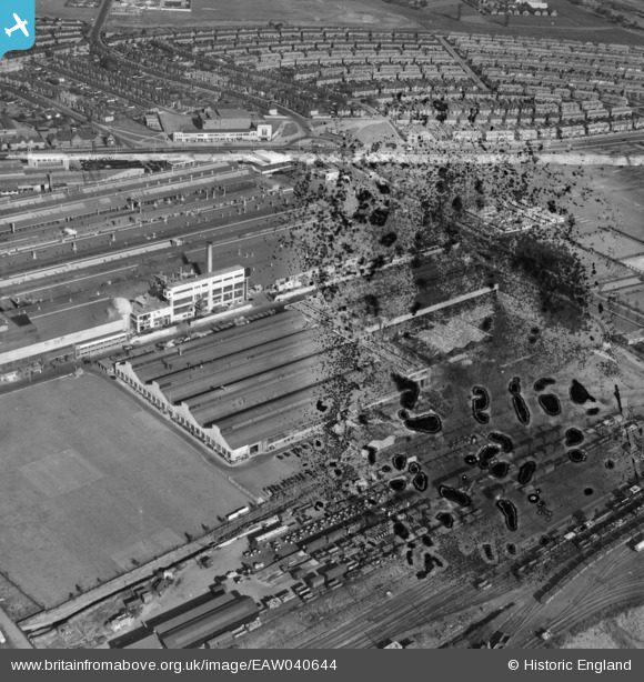
EAW040644 ENGLAND (1951). The Kelsey-Hayes Car Wheel Manufactory and environs, Dagenham, 1951. This image has been produced from a damaged negative.
© Copyright OpenStreetMap contributors and licensed by the OpenStreetMap Foundation. 2025. Cartography is licensed as CC BY-SA.
Nearby Images (36)
Details
| Title | [EAW040644] The Kelsey-Hayes Car Wheel Manufactory and environs, Dagenham, 1951. This image has been produced from a damaged negative. |
| Reference | EAW040644 |
| Date | 12-October-1951 |
| Link | |
| Place name | DAGENHAM |
| Parish | |
| District | |
| Country | ENGLAND |
| Easting / Northing | 549313, 183121 |
| Longitude / Latitude | 0.15267027954454, 51.526753083531 |
| National Grid Reference | TQ493831 |
Pins
Be the first to add a comment to this image!


![[EAW040644] The Kelsey-Hayes Car Wheel Manufactory and environs, Dagenham, 1951. This image has been produced from a damaged negative.](http://britainfromabove.org.uk/sites/all/libraries/aerofilms-images/public/100x100/EAW/040/EAW040644.jpg)
![[EAW026148] The Kelsey-Hayes Car Wheel Manufactory and the adjacent housing estate, Dagenham, 1949. This image was marked by Aerofilms Ltd for photo editing.](http://britainfromabove.org.uk/sites/all/libraries/aerofilms-images/public/100x100/EAW/026/EAW026148.jpg)
![[EAW026149] The Kelsey-Hayes Car Wheel Manufactory, Dagenham, 1949. This image was marked by Aerofilms Ltd for photo editing.](http://britainfromabove.org.uk/sites/all/libraries/aerofilms-images/public/100x100/EAW/026/EAW026149.jpg)
![[EAW026152] The Kelsey-Hayes Car Wheel Manufactory and the Briggs Car Body Manufactory, Dagenham, 1949. This image has been produced from a damaged negative.](http://britainfromabove.org.uk/sites/all/libraries/aerofilms-images/public/100x100/EAW/026/EAW026152.jpg)
![[EAW026150] The Kelsey-Hayes Car Wheel Manufactory and the Briggs Car Body Manufactory, Dagenham, 1949. This image has been produced from a damaged negative.](http://britainfromabove.org.uk/sites/all/libraries/aerofilms-images/public/100x100/EAW/026/EAW026150.jpg)
![[EAW040645] The Kelsey-Hayes Car Wheel Manufactory, Dagenham, 1951. This image has been produced from a damaged negative.](http://britainfromabove.org.uk/sites/all/libraries/aerofilms-images/public/100x100/EAW/040/EAW040645.jpg)
![[EAW040643] The Kelsey-Hayes Car Wheel Manufactory and environs, Dagenham, 1951. This image has been produced from a damaged negative.](http://britainfromabove.org.uk/sites/all/libraries/aerofilms-images/public/100x100/EAW/040/EAW040643.jpg)
![[EAW040647] The Kelsey-Hayes Car Wheel Manufactory, Dagenham, 1951. This image has been produced from a print marked by Aerofilms Ltd for photo editing.](http://britainfromabove.org.uk/sites/all/libraries/aerofilms-images/public/100x100/EAW/040/EAW040647.jpg)
![[EAW040641] The Kelsey-Hayes Car Wheel Manufactory, Dagenham, 1951](http://britainfromabove.org.uk/sites/all/libraries/aerofilms-images/public/100x100/EAW/040/EAW040641.jpg)
![[EAW026154] The Kelsey-Hayes Car Wheel Manufactory, Dagenham, 1949. This image was marked by Aerofilms Ltd for photo editing.](http://britainfromabove.org.uk/sites/all/libraries/aerofilms-images/public/100x100/EAW/026/EAW026154.jpg)
![[EAW026147] The Kelsey-Hayes Car Wheel Manufactory, Dagenham, 1949. This image was marked by Aerofilms Ltd for photo editing.](http://britainfromabove.org.uk/sites/all/libraries/aerofilms-images/public/100x100/EAW/026/EAW026147.jpg)
![[EAW040640] The Kelsey-Hayes Car Wheel Manufactory, Dagenham, 1951](http://britainfromabove.org.uk/sites/all/libraries/aerofilms-images/public/100x100/EAW/040/EAW040640.jpg)
![[EAW040642] The Kelsey-Hayes Car Wheel Manufactory and environs, Dagenham, from the south-east, 1951. This image has been produced from a damaged negative.](http://britainfromabove.org.uk/sites/all/libraries/aerofilms-images/public/100x100/EAW/040/EAW040642.jpg)
![[EPW037321] The Briggs Motor Bodies Works, Dagenham, 1932](http://britainfromabove.org.uk/sites/all/libraries/aerofilms-images/public/100x100/EPW/037/EPW037321.jpg)
![[EAW026153] The Kelsey-Hayes Car Wheel Manufactory and the Briggs Car Body Manufactory, Dagenham, 1949. This image has been produced from a damaged negative.](http://britainfromabove.org.uk/sites/all/libraries/aerofilms-images/public/100x100/EAW/026/EAW026153.jpg)
![[EAW016632] The Briggs Motor Bodies Ltd Manufactory, Dagenham, 1948. This image was marked by Aerofilms Ltd for photo editing.](http://britainfromabove.org.uk/sites/all/libraries/aerofilms-images/public/100x100/EAW/016/EAW016632.jpg)
![[EAW016634] The Briggs Motor Bodies Ltd Manufactory, Dagenham, 1948. This image was marked by Aerofilms Ltd for photo editing.](http://britainfromabove.org.uk/sites/all/libraries/aerofilms-images/public/100x100/EAW/016/EAW016634.jpg)
![[EAW016636] The Briggs Motor Bodies Ltd Manufactory, Dagenham, 1948. This image was marked by Aerofilms Ltd for photo editing.](http://britainfromabove.org.uk/sites/all/libraries/aerofilms-images/public/100x100/EAW/016/EAW016636.jpg)
![[EAW052717] The Briggs Motor Bodies Ltd Works and environs, Dagenham, from the south-west, 1953](http://britainfromabove.org.uk/sites/all/libraries/aerofilms-images/public/100x100/EAW/052/EAW052717.jpg)
![[EAW026159] The Briggs Car Body Manufactory, Dagenham, 1949](http://britainfromabove.org.uk/sites/all/libraries/aerofilms-images/public/100x100/EAW/026/EAW026159.jpg)
![[EAW016637] The Briggs Motor Bodies Ltd Manufactory, Dagenham, 1948. This image was marked by Aerofilms Ltd for photo editing.](http://britainfromabove.org.uk/sites/all/libraries/aerofilms-images/public/100x100/EAW/016/EAW016637.jpg)
![[EAW052718] The Briggs Motor Bodies Ltd Works and environs, Dagenham, 1953. This image was marked by Aerofilms Ltd for photo editing.](http://britainfromabove.org.uk/sites/all/libraries/aerofilms-images/public/100x100/EAW/052/EAW052718.jpg)
![[EAW052716] The Briggs Motor Bodies Ltd Works and environs, Dagenham, 1953. This image was marked by Aerofilms Ltd for photo editing.](http://britainfromabove.org.uk/sites/all/libraries/aerofilms-images/public/100x100/EAW/052/EAW052716.jpg)
![[EAW026157] The Briggs Car Body Manufactory, Dagenham, 1949. This image was marked by Aerofilms Ltd for photo editing.](http://britainfromabove.org.uk/sites/all/libraries/aerofilms-images/public/100x100/EAW/026/EAW026157.jpg)
![[EAW016635] The Briggs Motor Bodies Ltd Manufactory, Dagenham, 1948. This image was marked by Aerofilms Ltd for photo editing.](http://britainfromabove.org.uk/sites/all/libraries/aerofilms-images/public/100x100/EAW/016/EAW016635.jpg)
![[EAW052714] The Briggs Motor Bodies Ltd Works and environs, Dagenham, 1953. This image was marked by Aerofilms Ltd for photo editing.](http://britainfromabove.org.uk/sites/all/libraries/aerofilms-images/public/100x100/EAW/052/EAW052714.jpg)
![[EAW052722] The Briggs Motor Bodies Ltd Works and environs, Dagenham, 1953. This image was marked by Aerofilms Ltd for photo editing.](http://britainfromabove.org.uk/sites/all/libraries/aerofilms-images/public/100x100/EAW/052/EAW052722.jpg)
![[EAW052715] The Briggs Motor Bodies Ltd Works and environs, Dagenham, 1953. This image was marked by Aerofilms Ltd for photo editing.](http://britainfromabove.org.uk/sites/all/libraries/aerofilms-images/public/100x100/EAW/052/EAW052715.jpg)
![[EAW016633] The Briggs Motor Bodies Ltd Manufactory, Dagenham, 1948](http://britainfromabove.org.uk/sites/all/libraries/aerofilms-images/public/100x100/EAW/016/EAW016633.jpg)
![[EAW052721] The Briggs Motor Bodies Ltd Works and environs, Dagenham, 1953. This image was marked by Aerofilms Ltd for photo editing.](http://britainfromabove.org.uk/sites/all/libraries/aerofilms-images/public/100x100/EAW/052/EAW052721.jpg)
![[EPW037320] The Briggs Motor Bodies Works, Dagenham, 1932](http://britainfromabove.org.uk/sites/all/libraries/aerofilms-images/public/100x100/EPW/037/EPW037320.jpg)
![[EAW026151] The Kelsey-Hayes Car Wheel Manufactory and the Briggs Car Body Manufactory, Dagenham, 1949. This image has been produced from a damaged negative.](http://britainfromabove.org.uk/sites/all/libraries/aerofilms-images/public/100x100/EAW/026/EAW026151.jpg)
![[EAW026155] The Briggs Car Body Manufactory, Dagenham, 1949](http://britainfromabove.org.uk/sites/all/libraries/aerofilms-images/public/100x100/EAW/026/EAW026155.jpg)
![[EAW043575] Kent Avenue, New Road and environs, Dagenham, from the south, 1952](http://britainfromabove.org.uk/sites/all/libraries/aerofilms-images/public/100x100/EAW/043/EAW043575.jpg)
![[EAW016638] The Briggs Motor Bodies Ltd Manufactory, Dagenham, 1948. This image was marked by Aerofilms Ltd for photo editing.](http://britainfromabove.org.uk/sites/all/libraries/aerofilms-images/public/100x100/EAW/016/EAW016638.jpg)
![[EAW052720] The Briggs Motor Bodies Ltd Works and environs, Dagenham, from the south-west, 1953. This image was marked by Aerofilms Ltd for photo editing.](http://britainfromabove.org.uk/sites/all/libraries/aerofilms-images/public/100x100/EAW/052/EAW052720.jpg)