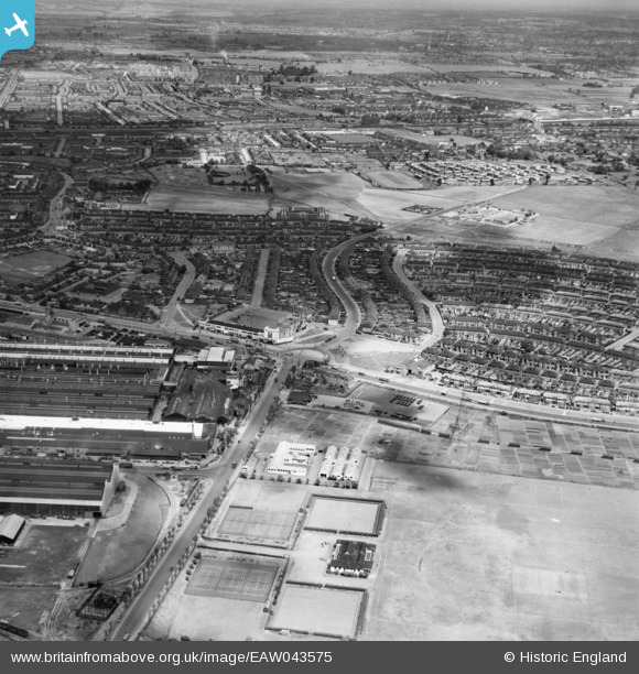
EAW043575 ENGLAND (1952). Kent Avenue, New Road and environs, Dagenham, from the south, 1952
© Copyright OpenStreetMap contributors and licensed by the OpenStreetMap Foundation. 2025. Cartography is licensed as CC BY-SA.
Nearby Images (15)
Details
| Title | [EAW043575] Kent Avenue, New Road and environs, Dagenham, from the south, 1952 |
| Reference | EAW043575 |
| Date | 4-June-1952 |
| Link | |
| Place name | DAGENHAM |
| Parish | |
| District | |
| Country | ENGLAND |
| Easting / Northing | 549555, 183175 |
| Longitude / Latitude | 0.15617950860432, 51.527174284767 |
| National Grid Reference | TQ496832 |
Pins
 jonnyace |
Wednesday 17th of January 2024 07:59:54 PM | |
 jonnyace |
Wednesday 17th of January 2024 07:58:45 PM | |
 jonnyace |
Wednesday 17th of January 2024 07:57:36 PM | |
 jonnyace |
Wednesday 17th of January 2024 07:54:16 PM | |
 jonnyace |
Wednesday 17th of January 2024 07:07:41 PM |


![[EAW043575] Kent Avenue, New Road and environs, Dagenham, from the south, 1952](http://britainfromabove.org.uk/sites/all/libraries/aerofilms-images/public/100x100/EAW/043/EAW043575.jpg)
![[EAW043576] Kent Avenue, New Road and the Old Dagenham Park area, Dagenham, from the south-east, 1952](http://britainfromabove.org.uk/sites/all/libraries/aerofilms-images/public/100x100/EAW/043/EAW043576.jpg)
![[EAW052716] The Briggs Motor Bodies Ltd Works and environs, Dagenham, 1953. This image was marked by Aerofilms Ltd for photo editing.](http://britainfromabove.org.uk/sites/all/libraries/aerofilms-images/public/100x100/EAW/052/EAW052716.jpg)
![[EAW052715] The Briggs Motor Bodies Ltd Works and environs, Dagenham, 1953. This image was marked by Aerofilms Ltd for photo editing.](http://britainfromabove.org.uk/sites/all/libraries/aerofilms-images/public/100x100/EAW/052/EAW052715.jpg)
![[EAW016637] The Briggs Motor Bodies Ltd Manufactory, Dagenham, 1948. This image was marked by Aerofilms Ltd for photo editing.](http://britainfromabove.org.uk/sites/all/libraries/aerofilms-images/public/100x100/EAW/016/EAW016637.jpg)
![[EAW026154] The Kelsey-Hayes Car Wheel Manufactory, Dagenham, 1949. This image was marked by Aerofilms Ltd for photo editing.](http://britainfromabove.org.uk/sites/all/libraries/aerofilms-images/public/100x100/EAW/026/EAW026154.jpg)
![[EAW040642] The Kelsey-Hayes Car Wheel Manufactory and environs, Dagenham, from the south-east, 1951. This image has been produced from a damaged negative.](http://britainfromabove.org.uk/sites/all/libraries/aerofilms-images/public/100x100/EAW/040/EAW040642.jpg)
![[EAW040644] The Kelsey-Hayes Car Wheel Manufactory and environs, Dagenham, 1951. This image has been produced from a damaged negative.](http://britainfromabove.org.uk/sites/all/libraries/aerofilms-images/public/100x100/EAW/040/EAW040644.jpg)
![[EAW026148] The Kelsey-Hayes Car Wheel Manufactory and the adjacent housing estate, Dagenham, 1949. This image was marked by Aerofilms Ltd for photo editing.](http://britainfromabove.org.uk/sites/all/libraries/aerofilms-images/public/100x100/EAW/026/EAW026148.jpg)
![[EAW052719] The Briggs Motor Bodies Ltd Works and environs, Dagenham, 1953. This image was marked by Aerofilms Ltd for photo editing.](http://britainfromabove.org.uk/sites/all/libraries/aerofilms-images/public/100x100/EAW/052/EAW052719.jpg)
![[EAW052714] The Briggs Motor Bodies Ltd Works and environs, Dagenham, 1953. This image was marked by Aerofilms Ltd for photo editing.](http://britainfromabove.org.uk/sites/all/libraries/aerofilms-images/public/100x100/EAW/052/EAW052714.jpg)
![[EAW052722] The Briggs Motor Bodies Ltd Works and environs, Dagenham, 1953. This image was marked by Aerofilms Ltd for photo editing.](http://britainfromabove.org.uk/sites/all/libraries/aerofilms-images/public/100x100/EAW/052/EAW052722.jpg)
![[EAW040641] The Kelsey-Hayes Car Wheel Manufactory, Dagenham, 1951](http://britainfromabove.org.uk/sites/all/libraries/aerofilms-images/public/100x100/EAW/040/EAW040641.jpg)
![[EAW040643] The Kelsey-Hayes Car Wheel Manufactory and environs, Dagenham, 1951. This image has been produced from a damaged negative.](http://britainfromabove.org.uk/sites/all/libraries/aerofilms-images/public/100x100/EAW/040/EAW040643.jpg)
![[EAW026156] The Briggs Car Body Manufactory, Dagenham, 1949. This image was marked by Aerofilms Ltd for photo editing.](http://britainfromabove.org.uk/sites/all/libraries/aerofilms-images/public/100x100/EAW/026/EAW026156.jpg)