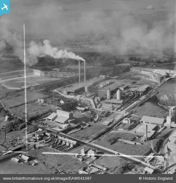
EAW041087 ENGLAND (1951). The Metropolitan and the Aluminous Cement Works, West Thurrock, from the south-east, 1951. This image was marked by Aerofilms Ltd for photo editing.
© Copyright OpenStreetMap contributors and licensed by the OpenStreetMap Foundation. 2025. Cartography is licensed as CC BY-SA.
Nearby Images (36)
Details
| Title | [EAW041087] The Metropolitan and the Aluminous Cement Works, West Thurrock, from the south-east, 1951. This image was marked by Aerofilms Ltd for photo editing. |
| Reference | EAW041087 |
| Date | 25-October-1951 |
| Link | |
| Place name | WEST THURROCK |
| Parish | |
| District | |
| Country | ENGLAND |
| Easting / Northing | 557415, 177826 |
| Longitude / Latitude | 0.26701908129576, 51.476974544108 |
| National Grid Reference | TQ574778 |
Pins
 Dylan Moore |
Sunday 27th of April 2014 12:53:59 PM | |
 Dylan Moore |
Sunday 27th of April 2014 12:45:45 PM | |
 Dylan Moore |
Sunday 27th of April 2014 12:44:49 PM | |
 Dylan Moore |
Sunday 27th of April 2014 12:44:29 PM | |
 Dylan Moore |
Sunday 27th of April 2014 12:32:47 PM | |
 Dylan Moore |
Sunday 27th of April 2014 12:31:41 PM | |
 Dylan Moore |
Sunday 27th of April 2014 12:28:00 PM |


![[EAW041087] The Metropolitan and the Aluminous Cement Works, West Thurrock, from the south-east, 1951. This image was marked by Aerofilms Ltd for photo editing.](http://britainfromabove.org.uk/sites/all/libraries/aerofilms-images/public/100x100/EAW/041/EAW041087.jpg)
![[EPW061838] The Metropolitan Portland Cement Works and the Fondu Aluminous Cement Works, West Thurrock, 1939. This image has been affected by flare.](http://britainfromabove.org.uk/sites/all/libraries/aerofilms-images/public/100x100/EPW/061/EPW061838.jpg)
![[EAW021518] The Fondu Aluminous Cement Works, Metropolitan Portland Cement Works and Thurrock Chalk Quarries, West Thurrock, from the south, 1949. This image has been produced from a print marked by Aerofilms Ltd for photo editing.](http://britainfromabove.org.uk/sites/all/libraries/aerofilms-images/public/100x100/EAW/021/EAW021518.jpg)
![[EPW061841] The Metropolitan Portland Cement Works and the Fondu Aluminous Cement Works, West Thurrock, 1939](http://britainfromabove.org.uk/sites/all/libraries/aerofilms-images/public/100x100/EPW/061/EPW061841.jpg)
![[EAW041092] The Metropolitan and the Aluminous Cement Works, West Thurrock, from the south, 1951. This image was marked by Aerofilms Ltd for photo editing.](http://britainfromabove.org.uk/sites/all/libraries/aerofilms-images/public/100x100/EAW/041/EAW041092.jpg)
![[EPW061839] The Metropolitan Portland Cement Works and the Fondu Aluminous Cement Works, West Thurrock, 1939](http://britainfromabove.org.uk/sites/all/libraries/aerofilms-images/public/100x100/EPW/061/EPW061839.jpg)
![[EAW021522] Thurrock Chalk Quarries, the Metropolitan Portland Cement Works and the Fondu Aluminous Cement Works, West Thurrock, from the south, 1949. This image has been produced from a damaged negative.](http://britainfromabove.org.uk/sites/all/libraries/aerofilms-images/public/100x100/EAW/021/EAW021522.jpg)
![[EPW061840] The Metropolitan Portland Cement Works and the Fondu Aluminous Cement Works, West Thurrock, 1939](http://britainfromabove.org.uk/sites/all/libraries/aerofilms-images/public/100x100/EPW/061/EPW061840.jpg)
![[EPW026638] Houses on the London Road to the west of Thurrock Chalk Quarries, West Thurrock, 1929](http://britainfromabove.org.uk/sites/all/libraries/aerofilms-images/public/100x100/EPW/026/EPW026638.jpg)
![[EAW021519] Thurrock Chalk Quarries, the Metropolitan Portland Cement Works and the Fondu Aluminous Cement Works (site of), West Thurrock, 1949. This image has been produced from a damaged negative.](http://britainfromabove.org.uk/sites/all/libraries/aerofilms-images/public/100x100/EAW/021/EAW021519.jpg)
![[EPW061842] The Metropolitan Portland Cement Works and the Fondu Aluminous Cement Works, West Thurrock, 1939](http://britainfromabove.org.uk/sites/all/libraries/aerofilms-images/public/100x100/EPW/061/EPW061842.jpg)
![[EAW021516] The Fondu Aluminous Cement Works, Metropolitan Portland Cement Works and Thurrock Chalk Quarries, West Thurrock, 1949. This image has been produced from a print marked by Aerofilms Ltd for photo editing.](http://britainfromabove.org.uk/sites/all/libraries/aerofilms-images/public/100x100/EAW/021/EAW021516.jpg)
![[EPW026642] Houses on the London Road to the west of Thurrock Chalk Quarries, West Thurrock, 1929](http://britainfromabove.org.uk/sites/all/libraries/aerofilms-images/public/100x100/EPW/026/EPW026642.jpg)
![[EPW026637] Houses on the London Road to the west of Thurrock Chalk Quarries, West Thurrock, 1929](http://britainfromabove.org.uk/sites/all/libraries/aerofilms-images/public/100x100/EPW/026/EPW026637.jpg)
![[EAW041095] The Metropolitan and the Aluminous Cement Works, West Thurrock, from the south, 1951](http://britainfromabove.org.uk/sites/all/libraries/aerofilms-images/public/100x100/EAW/041/EAW041095.jpg)
![[EPW061843] The Metropolitan Portland Cement Works and the Fondu Aluminous Cement Works, West Thurrock, 1939](http://britainfromabove.org.uk/sites/all/libraries/aerofilms-images/public/100x100/EPW/061/EPW061843.jpg)
![[EAW021512] The Fondu Aluminous Cement Works, Metropolitan Portland Cement Works and Thurrock Chalk Quarries, West Thurrock, 1949. This image has been produced from a print marked by Aerofilms Ltd for photo editing.](http://britainfromabove.org.uk/sites/all/libraries/aerofilms-images/public/100x100/EAW/021/EAW021512.jpg)
![[EPW027529] The Thurrock Chalk Quarries and the Metropolitan Cement Works, West Thurrock, 1929](http://britainfromabove.org.uk/sites/all/libraries/aerofilms-images/public/100x100/EPW/027/EPW027529.jpg)
![[EPW046464] The Tunnel Portland Cement Works, West Thurrock, 1935](http://britainfromabove.org.uk/sites/all/libraries/aerofilms-images/public/100x100/EPW/046/EPW046464.jpg)
![[EPW039475] The Tunnel Cement Works and the Thurrock Chalk Quarries, West Thurrock, 1932](http://britainfromabove.org.uk/sites/all/libraries/aerofilms-images/public/100x100/EPW/039/EPW039475.jpg)
![[EAW021513] The Fondu Aluminous Cement Works, Metropolitan Portland Cement Works and Thurrock Chalk Quarries, West Thurrock, 1949. This image has been produced from a print marked by Aerofilms Ltd for photo editing.](http://britainfromabove.org.uk/sites/all/libraries/aerofilms-images/public/100x100/EAW/021/EAW021513.jpg)
![[EPW057051] The Tunnel Portland Cement Works, West Thurrock, from the south-west, 1938](http://britainfromabove.org.uk/sites/all/libraries/aerofilms-images/public/100x100/EPW/057/EPW057051.jpg)
![[EPW039476] The Tunnel Cement Works and the Thurrock Chalk Quarries, West Thurrock, 1932](http://britainfromabove.org.uk/sites/all/libraries/aerofilms-images/public/100x100/EPW/039/EPW039476.jpg)
![[EAW041188] The Lafarge Aluminous Cement Co Works, West Thurrock, 1951. This image has been produced from a print marked by Aerofilms Ltd for photo editing.](http://britainfromabove.org.uk/sites/all/libraries/aerofilms-images/public/100x100/EAW/041/EAW041188.jpg)
![[EAW041191] The Lafarge Aluminous Cement Co Works, West Thurrock, 1951. This image has been produced from a print marked by Aerofilms Ltd for photo editing.](http://britainfromabove.org.uk/sites/all/libraries/aerofilms-images/public/100x100/EAW/041/EAW041191.jpg)
![[EAW041088] The Metropolitan and the Aluminous Cement Works, West Thurrock, 1951. This image was marked by Aerofilms Ltd for photo editing.](http://britainfromabove.org.uk/sites/all/libraries/aerofilms-images/public/100x100/EAW/041/EAW041088.jpg)
![[EAW021511] The Fondu Aluminous Cement Works, Metropolitan Portland Cement Works and Thurrock Chalk Quarries, West Thurrock, 1949. This image has been produced from a print marked by Aerofilms Ltd for photo editing.](http://britainfromabove.org.uk/sites/all/libraries/aerofilms-images/public/100x100/EAW/021/EAW021511.jpg)
![[EAW021517] The Fondu Aluminous Cement Works, Metropolitan Portland Cement Works and Thurrock Chalk Quarries, West Thurrock, 1949. This image has been produced from a print marked by Aerofilms Ltd for photo editing.](http://britainfromabove.org.uk/sites/all/libraries/aerofilms-images/public/100x100/EAW/021/EAW021517.jpg)
![[EPW039471] The Tunnel Cement Works, West Thurrock, 1932](http://britainfromabove.org.uk/sites/all/libraries/aerofilms-images/public/100x100/EPW/039/EPW039471.jpg)
![[EAW021515] The Fondu Aluminous Cement Works, Metropolitan Portland Cement Works and Thurrock Chalk Quarries, West Thurrock, 1949. This image has been produced from a print marked by Aerofilms Ltd for photo editing.](http://britainfromabove.org.uk/sites/all/libraries/aerofilms-images/public/100x100/EAW/021/EAW021515.jpg)
![[EPW026640] The Tunnel Portland Cement Works, West Thurrock, 1929](http://britainfromabove.org.uk/sites/all/libraries/aerofilms-images/public/100x100/EPW/026/EPW026640.jpg)
![[EPW027526] The Thurrock Chalk Quarries and the Metropolitan Cement Works, West Thurrock, 1929](http://britainfromabove.org.uk/sites/all/libraries/aerofilms-images/public/100x100/EPW/027/EPW027526.jpg)
![[EPW032826] The Fondu Aluminous Cement Works and environs, West Thurrock, 1930](http://britainfromabove.org.uk/sites/all/libraries/aerofilms-images/public/100x100/EPW/032/EPW032826.jpg)
![[EPW046463] The Tunnel Portland Cement Works, West Thurrock, 1935](http://britainfromabove.org.uk/sites/all/libraries/aerofilms-images/public/100x100/EPW/046/EPW046463.jpg)
![[EPW026644] The Tunnel Portland Cement Works, West Thurrock, 1929](http://britainfromabove.org.uk/sites/all/libraries/aerofilms-images/public/100x100/EPW/026/EPW026644.jpg)
![[EPW039474] The Tunnel Cement Works, West Thurrock, 1932](http://britainfromabove.org.uk/sites/all/libraries/aerofilms-images/public/100x100/EPW/039/EPW039474.jpg)