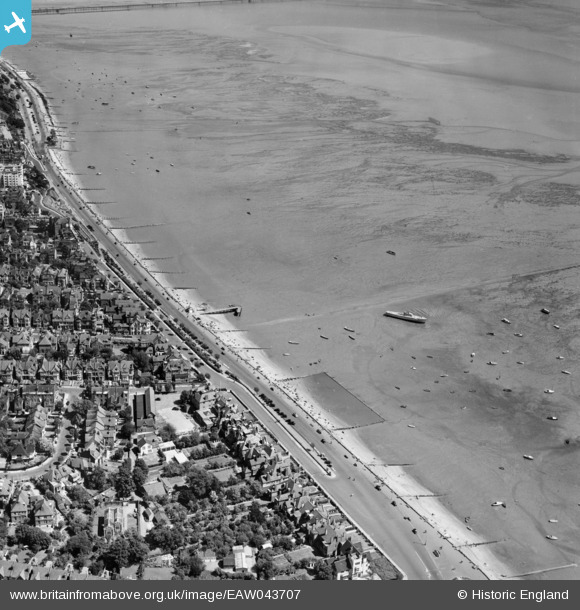
EAW043707 ENGLAND (1952). Western Esplanade, Westcliff-on-Sea, 1952
© Copyright OpenStreetMap contributors and licensed by the OpenStreetMap Foundation. 2025. Cartography is licensed as CC BY-SA.
Nearby Images (19)
Details
| Title | [EAW043707] Western Esplanade, Westcliff-on-Sea, 1952 |
| Reference | EAW043707 |
| Date | 4-June-1952 |
| Link | |
| Place name | WESTCLIFF-ON-SEA |
| Parish | |
| District | |
| Country | ENGLAND |
| Easting / Northing | 586396, 185194 |
| Longitude / Latitude | 0.68782944218297, 51.534352457961 |
| National Grid Reference | TQ864852 |


![[EAW043707] Western Esplanade, Westcliff-on-Sea, 1952](http://britainfromabove.org.uk/sites/all/libraries/aerofilms-images/public/100x100/EAW/043/EAW043707.jpg)
![[EPW040985] The Western Esplanade, the seafront and Westcliff-on-Sea, Southend-on-Sea, from the south-east, 1933](http://britainfromabove.org.uk/sites/all/libraries/aerofilms-images/public/100x100/EPW/040/EPW040985.jpg)
![[EPW037022] The Westcliff Jetty, Pembury Road and environs, Westcliff-on-Sea, from the south, 1931](http://britainfromabove.org.uk/sites/all/libraries/aerofilms-images/public/100x100/EPW/037/EPW037022.jpg)
![[EAW053103] Westcliff Jetty and the Mount Liell Hotel, Southend-on-Sea, 1954](http://britainfromabove.org.uk/sites/all/libraries/aerofilms-images/public/100x100/EAW/053/EAW053103.jpg)
![[EAW043706] Western Esplanade, Westcliff-on-Sea, 1952](http://britainfromabove.org.uk/sites/all/libraries/aerofilms-images/public/100x100/EAW/043/EAW043706.jpg)
![[EPW024884] Westcliff Jetty and the town, Westcliff-on-Sea, 1928](http://britainfromabove.org.uk/sites/all/libraries/aerofilms-images/public/100x100/EPW/024/EPW024884.jpg)
![[EPW054674] The Western Esplanade, The Leas and Westcliff-on-Sea, Chalkwell, from the south-west, 1937](http://britainfromabove.org.uk/sites/all/libraries/aerofilms-images/public/100x100/EPW/054/EPW054674.jpg)
![[EPW024876] Westcliff Jetty, Western Esplanade and the town, Westcliff-on-Sea, 1928](http://britainfromabove.org.uk/sites/all/libraries/aerofilms-images/public/100x100/EPW/024/EPW024876.jpg)
![[EPW040969] The Western Esplanade and the town alongside the seafront, Southend-on-Sea, from the south-east, 1933](http://britainfromabove.org.uk/sites/all/libraries/aerofilms-images/public/100x100/EPW/040/EPW040969.jpg)
![[EPW000543] Westcliff-on-Sea, Southend-on-Sea, 1920](http://britainfromabove.org.uk/sites/all/libraries/aerofilms-images/public/100x100/EPW/000/EPW000543.jpg)
![[EPW037019] The Leas and Westcliff Jetty, Westcliff-on-Sea, 1931](http://britainfromabove.org.uk/sites/all/libraries/aerofilms-images/public/100x100/EPW/037/EPW037019.jpg)
![[EPW037023] The Western Esplanade, Palmerston Road and environs, Westcliff-on-Sea, 1931](http://britainfromabove.org.uk/sites/all/libraries/aerofilms-images/public/100x100/EPW/037/EPW037023.jpg)
![[EAW053092] The Overcliff Hotel and Palmerston Road, Southend-on-Sea, from the south, 1954](http://britainfromabove.org.uk/sites/all/libraries/aerofilms-images/public/100x100/EAW/053/EAW053092.jpg)
![[EPW037025] The Western Esplanade, Manor Road and environs, Westcliff-on-Sea, 1931](http://britainfromabove.org.uk/sites/all/libraries/aerofilms-images/public/100x100/EPW/037/EPW037025.jpg)
![[EPW037018] The Leas and the Paddling Pool, Westcliff-on-Sea, from the south, 1931](http://britainfromabove.org.uk/sites/all/libraries/aerofilms-images/public/100x100/EPW/037/EPW037018.jpg)
![[EPW036732] The Western Esplanade and housing surrounding Pembury Road and Palmerston Road, Southend-on-Sea, 1931](http://britainfromabove.org.uk/sites/all/libraries/aerofilms-images/public/100x100/EPW/036/EPW036732.jpg)
![[EPW054668] Argyll House, the Western Esplanade, Clifton Drive and the town, Westcliff-on-Sea, from the south-west, 1937](http://britainfromabove.org.uk/sites/all/libraries/aerofilms-images/public/100x100/EPW/054/EPW054668.jpg)
![[EAW043704] Paddling Pool at Western Esplanade and the town, Westcliff-on-Sea, 1952](http://britainfromabove.org.uk/sites/all/libraries/aerofilms-images/public/100x100/EAW/043/EAW043704.jpg)
![[EPW032902] The Leas and Whitefriars Crescent, Chalkwell, 1930](http://britainfromabove.org.uk/sites/all/libraries/aerofilms-images/public/100x100/EPW/032/EPW032902.jpg)
