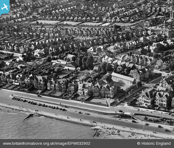
EPW032902 ENGLAND (1930). The Leas and Whitefriars Crescent, Chalkwell, 1930
© Copyright OpenStreetMap contributors and licensed by the OpenStreetMap Foundation. 2025. Cartography is licensed as CC BY-SA.
Nearby Images (17)
Details
| Title | [EPW032902] The Leas and Whitefriars Crescent, Chalkwell, 1930 |
| Reference | EPW032902 |
| Date | June-1930 |
| Link | |
| Place name | CHALKWELL |
| Parish | |
| District | |
| Country | ENGLAND |
| Easting / Northing | 586150, 185410 |
| Longitude / Latitude | 0.68440052548133, 51.536373864915 |
| National Grid Reference | TQ862854 |
Pins
Be the first to add a comment to this image!


![[EPW032902] The Leas and Whitefriars Crescent, Chalkwell, 1930](http://britainfromabove.org.uk/sites/all/libraries/aerofilms-images/public/100x100/EPW/032/EPW032902.jpg)
![[EPW024867] Residential area around Crowstone Avenue, Westcliff-on-Sea, 1928](http://britainfromabove.org.uk/sites/all/libraries/aerofilms-images/public/100x100/EPW/024/EPW024867.jpg)
![[EAW043704] Paddling Pool at Western Esplanade and the town, Westcliff-on-Sea, 1952](http://britainfromabove.org.uk/sites/all/libraries/aerofilms-images/public/100x100/EAW/043/EAW043704.jpg)
![[EPW036716] Housing surrounding Crowstone Avenue and Chalkwell Esplanade, Southend-on-Sea, 1931](http://britainfromabove.org.uk/sites/all/libraries/aerofilms-images/public/100x100/EPW/036/EPW036716.jpg)
![[EPW037018] The Leas and the Paddling Pool, Westcliff-on-Sea, from the south, 1931](http://britainfromabove.org.uk/sites/all/libraries/aerofilms-images/public/100x100/EPW/037/EPW037018.jpg)
![[EPW036989] Crowstone Avenue and environs, Southend-on-Sea, from the south-west, 1931](http://britainfromabove.org.uk/sites/all/libraries/aerofilms-images/public/100x100/EPW/036/EPW036989.jpg)
![[EPW037019] The Leas and Westcliff Jetty, Westcliff-on-Sea, 1931](http://britainfromabove.org.uk/sites/all/libraries/aerofilms-images/public/100x100/EPW/037/EPW037019.jpg)
![[EPW024876] Westcliff Jetty, Western Esplanade and the town, Westcliff-on-Sea, 1928](http://britainfromabove.org.uk/sites/all/libraries/aerofilms-images/public/100x100/EPW/024/EPW024876.jpg)
![[EPW054674] The Western Esplanade, The Leas and Westcliff-on-Sea, Chalkwell, from the south-west, 1937](http://britainfromabove.org.uk/sites/all/libraries/aerofilms-images/public/100x100/EPW/054/EPW054674.jpg)
![[EAW043706] Western Esplanade, Westcliff-on-Sea, 1952](http://britainfromabove.org.uk/sites/all/libraries/aerofilms-images/public/100x100/EAW/043/EAW043706.jpg)
![[EPW036711] Chalkwell Esplanade and the town, Southend-on-Sea, 1931](http://britainfromabove.org.uk/sites/all/libraries/aerofilms-images/public/100x100/EPW/036/EPW036711.jpg)
![[EAW053103] Westcliff Jetty and the Mount Liell Hotel, Southend-on-Sea, 1954](http://britainfromabove.org.uk/sites/all/libraries/aerofilms-images/public/100x100/EAW/053/EAW053103.jpg)
![[EPW024884] Westcliff Jetty and the town, Westcliff-on-Sea, 1928](http://britainfromabove.org.uk/sites/all/libraries/aerofilms-images/public/100x100/EPW/024/EPW024884.jpg)
![[EPW037002] Chalkwell Esplanade, Crowstone Avenue and environs, Chalkwell, from the south-west, 1931](http://britainfromabove.org.uk/sites/all/libraries/aerofilms-images/public/100x100/EPW/037/EPW037002.jpg)
![[EPW024864] Residential area around Grosvenor Road and Alba Road, Westcliff-on-Sea, 1928](http://britainfromabove.org.uk/sites/all/libraries/aerofilms-images/public/100x100/EPW/024/EPW024864.jpg)
![[EPW040970] The Chalkwell Esplanade and Chalkwell, Southend-on-Sea, from the south, 1933](http://britainfromabove.org.uk/sites/all/libraries/aerofilms-images/public/100x100/EPW/040/EPW040970.jpg)
![[EAW043707] Western Esplanade, Westcliff-on-Sea, 1952](http://britainfromabove.org.uk/sites/all/libraries/aerofilms-images/public/100x100/EAW/043/EAW043707.jpg)