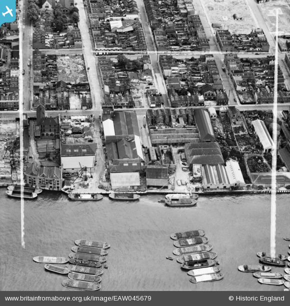
EAW045679 ENGLAND (1952). Express Wharf, Millwall, 1952. This image was marked by Aerofilms Ltd for photo editing.
© Copyright OpenStreetMap contributors and licensed by the OpenStreetMap Foundation. 2025. Cartography is licensed as CC BY-SA.
Nearby Images (17)
Details
| Title | [EAW045679] Express Wharf, Millwall, 1952. This image was marked by Aerofilms Ltd for photo editing. |
| Reference | EAW045679 |
| Date | 31-July-1952 |
| Link | |
| Place name | MILLWALL |
| Parish | |
| District | |
| Country | ENGLAND |
| Easting / Northing | 537069, 179655 |
| Longitude / Latitude | -0.025083468127123, 51.498709014033 |
| National Grid Reference | TQ371797 |


![[EAW045679] Express Wharf, Millwall, 1952. This image was marked by Aerofilms Ltd for photo editing.](http://britainfromabove.org.uk/sites/all/libraries/aerofilms-images/public/100x100/EAW/045/EAW045679.jpg)
![[EAW045675] Express Wharf, Millwall, 1952. This image was marked by Aerofilms Ltd for photo editing.](http://britainfromabove.org.uk/sites/all/libraries/aerofilms-images/public/100x100/EAW/045/EAW045675.jpg)
![[EAW045677] Express Wharf, Millwall, 1952. This image was marked by Aerofilms Ltd for photo editing.](http://britainfromabove.org.uk/sites/all/libraries/aerofilms-images/public/100x100/EAW/045/EAW045677.jpg)
![[EAW045673] Express Wharf, Millwall, 1952. This image was marked by Aerofilms Ltd for photo editing.](http://britainfromabove.org.uk/sites/all/libraries/aerofilms-images/public/100x100/EAW/045/EAW045673.jpg)
![[EAW045678] Express Wharf, Millwall, 1952. This image was marked by Aerofilms Ltd for photo editing.](http://britainfromabove.org.uk/sites/all/libraries/aerofilms-images/public/100x100/EAW/045/EAW045678.jpg)
![[EAW045674] Express Wharf, Millwall, 1952. This image was marked by Aerofilms Ltd for photo editing.](http://britainfromabove.org.uk/sites/all/libraries/aerofilms-images/public/100x100/EAW/045/EAW045674.jpg)
![[EAW045810] West Ferry Road and environs, Millwall, 1952. This image was marked by Aerofilms Ltd for photo editing.](http://britainfromabove.org.uk/sites/all/libraries/aerofilms-images/public/100x100/EAW/045/EAW045810.jpg)
![[EAW045680] Express Wharf, Millwall, 1952. This image was marked by Aerofilms Ltd for photo editing.](http://britainfromabove.org.uk/sites/all/libraries/aerofilms-images/public/100x100/EAW/045/EAW045680.jpg)
![[EAW045676] Express Wharf, Millwall, 1952. This image was marked by Aerofilms Ltd for photo editing.](http://britainfromabove.org.uk/sites/all/libraries/aerofilms-images/public/100x100/EAW/045/EAW045676.jpg)
![[EAW045812] Wharfage on the River Thames behind West Ferry Road, Millwall, 1952. This image was marked by Aerofilms Ltd for photo editing.](http://britainfromabove.org.uk/sites/all/libraries/aerofilms-images/public/100x100/EAW/045/EAW045812.jpg)
![[EAW045807] Wharfage on the River Thames behind West Ferry Road, Millwall, 1952. This image was marked by Aerofilms Ltd for photo editing.](http://britainfromabove.org.uk/sites/all/libraries/aerofilms-images/public/100x100/EAW/045/EAW045807.jpg)
![[EAW045809] Byng Street, Strafford Street and wharfage on the River Thames behind West Ferry Road, Millwall, 1952. This image was marked by Aerofilms Ltd for photo editing.](http://britainfromabove.org.uk/sites/all/libraries/aerofilms-images/public/100x100/EAW/045/EAW045809.jpg)
![[EAW045808] Strafford Street and wharfage on the River Thames behind West Ferry Road, Millwall, 1952. This image was marked by Aerofilms Ltd for photo editing.](http://britainfromabove.org.uk/sites/all/libraries/aerofilms-images/public/100x100/EAW/045/EAW045808.jpg)
![[EAW045811] Wharfage on the River Thames behind West Ferry Road, Millwall, 1952. This image was marked by Aerofilms Ltd for photo editing.](http://britainfromabove.org.uk/sites/all/libraries/aerofilms-images/public/100x100/EAW/045/EAW045811.jpg)
![[EPW060776] The River Thames and surrounding city from Rotherhithe towards the Royal Docks, Isle of Dogs, from the south-west, 1939](http://britainfromabove.org.uk/sites/all/libraries/aerofilms-images/public/100x100/EPW/060/EPW060776.jpg)
![[EAW045813] Wharfage on the River Thames behind West Ferry Road, Millwall, 1952. This image was marked by Aerofilms Ltd for photo editing.](http://britainfromabove.org.uk/sites/all/libraries/aerofilms-images/public/100x100/EAW/045/EAW045813.jpg)
![[EPW006141] Millwall, Isle of Dogs, 1921](http://britainfromabove.org.uk/sites/all/libraries/aerofilms-images/public/100x100/EPW/006/EPW006141.jpg)
