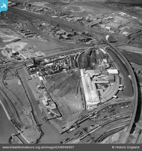
EAW046907 ENGLAND (1952). Fisons Ltd Works at the West Bank Dock Estate and the railway viaduct, Widnes, 1952
© Copyright OpenStreetMap contributors and licensed by the OpenStreetMap Foundation. 2025. Cartography is licensed as CC BY-SA.
Nearby Images (17)
Details
| Title | [EAW046907] Fisons Ltd Works at the West Bank Dock Estate and the railway viaduct, Widnes, 1952 |
| Reference | EAW046907 |
| Date | September-1952 |
| Link | |
| Place name | WIDNES |
| Parish | |
| District | |
| Country | ENGLAND |
| Easting / Northing | 350636, 384238 |
| Longitude / Latitude | -2.7416952453136, 53.352453756351 |
| National Grid Reference | SJ506842 |
Pins
 Ginger79 |
Saturday 12th of April 2025 12:55:33 AM | |
 Ginger79 |
Saturday 12th of April 2025 12:54:58 AM | |
 Ginger79 |
Saturday 24th of December 2022 03:03:14 AM | |
 Ginger79 |
Friday 25th of June 2021 04:54:58 PM | |
 redmist |
Thursday 23rd of July 2020 08:53:18 PM | |
 redmist |
Thursday 23rd of July 2020 08:52:04 PM | |
 Ginger79 |
Wednesday 15th of January 2020 05:16:23 AM | |
 Ginger79 |
Wednesday 15th of January 2020 05:15:36 AM | |
 Ginger79 |
Saturday 20th of July 2019 11:12:06 PM | |
 Ginger79 |
Saturday 20th of July 2019 11:11:01 PM | |
 Ginger79 |
Saturday 20th of July 2019 11:10:24 PM | |
 Ginger79 |
Saturday 20th of July 2019 11:09:38 PM | |
 Ginger79 |
Saturday 20th of July 2019 11:09:09 PM | |
 Ginger79 |
Saturday 20th of July 2019 11:08:01 PM | |
 Ginger79 |
Saturday 20th of July 2019 11:07:30 PM | |
 Ginger79 |
Saturday 20th of July 2019 11:06:27 PM | |
 Ginger79 |
Saturday 20th of July 2019 11:05:51 PM | |
 Ginger79 |
Saturday 20th of July 2019 10:11:42 PM | |
 redmist |
Thursday 28th of March 2019 12:48:47 AM | |
 Bottom Yard |
Friday 8th of March 2019 04:25:37 PM | |
 Bottom Yard |
Monday 21st of January 2019 05:47:55 PM | |
 Bottom Yard |
Monday 21st of January 2019 05:43:11 PM | |
 Bottom Yard |
Monday 21st of January 2019 05:24:31 PM | |
wrong a steam powered mersey flat it has a chimney |
 Ginger79 |
Saturday 24th of December 2022 03:02:25 AM |
 Ginger79 |
Sunday 17th of January 2016 07:28:05 PM | |
 Ginger79 |
Thursday 8th of October 2015 11:27:11 PM | |
 Ginger79 |
Thursday 8th of October 2015 11:26:06 PM | |
 Ginger79 |
Thursday 8th of October 2015 11:24:54 PM | |
Mersey Flat Demasted YOUR PIC IS CORRECT, YOUR PIN iS WRONG AGAIN & AGAIN, MERSEY FLATS WERE BUILT TO FIT IN LOCKS ON THE BRIDGEWATER, AND WEAVER RIVER, & CANAL 72 FEET LONG, 14 FEET, 14 ft,6,9 inches wide,( narrow boats 72ft x 7ft motor and butty, towed barge side by side fit ten flight at Runcorn OR ONE MERSEY FLAT) hundreds built as dumb barges and never fitted with sail or mast to much faffing about lowering masts booms stowing sails,lack of wind,tide so all at this time towed a few family private owned still in sail.last working steel flats sold 1977. |
 Bottom Yard |
Friday 8th of March 2019 04:52:06 PM |
NOT,NOT, A MERSEY FLAT. PIC IS, WORKED EM. |
 Bottom Yard |
Monday 21st of January 2019 05:26:45 PM |
 Ginger79 |
Thursday 8th of October 2015 11:20:52 PM | |
 Ginger79 |
Thursday 8th of October 2015 11:17:48 PM | |
 beast66606 |
Thursday 19th of June 2014 10:37:01 AM |


![[EAW046907] Fisons Ltd Works at the West Bank Dock Estate and the railway viaduct, Widnes, 1952](http://britainfromabove.org.uk/sites/all/libraries/aerofilms-images/public/100x100/EAW/046/EAW046907.jpg)
![[EAW046910] Fisons Ltd Works at the West Bank Dock Estate and the railway viaduct, Widnes, 1952. This image was marked by Aerofilms Ltd for photo editing.](http://britainfromabove.org.uk/sites/all/libraries/aerofilms-images/public/100x100/EAW/046/EAW046910.jpg)
![[EAW046908] Fisons Ltd Works at the West Bank Dock Estate and the railway viaduct, Widnes, 1952. This image was marked by Aerofilms Ltd for photo editing.](http://britainfromabove.org.uk/sites/all/libraries/aerofilms-images/public/100x100/EAW/046/EAW046908.jpg)
![[EPW024958] Railway viaduct and Thomas Vickers & Sons Limited, Widnes, 1928](http://britainfromabove.org.uk/sites/all/libraries/aerofilms-images/public/100x100/EPW/024/EPW024958.jpg)
![[EPW024956] Railway viaduct and Thomas Vickers & Sons Limited, Widnes, 1928](http://britainfromabove.org.uk/sites/all/libraries/aerofilms-images/public/100x100/EPW/024/EPW024956.jpg)
![[EAW046905] Fisons Ltd Works at the West Bank Dock Estate and the railway viaduct, Widnes, 1952. This image was marked by Aerofilms Ltd for photo editing.](http://britainfromabove.org.uk/sites/all/libraries/aerofilms-images/public/100x100/EAW/046/EAW046905.jpg)
![[EPW024951] Railway viaduct and Thomas Vickers & Sons Limited, Widnes, 1928](http://britainfromabove.org.uk/sites/all/libraries/aerofilms-images/public/100x100/EPW/024/EPW024951.jpg)
![[EAW046909] Fisons Ltd Works at the West Bank Dock Estate and the railway viaduct, Widnes, 1952. This image was marked by Aerofilms Ltd for photo editing.](http://britainfromabove.org.uk/sites/all/libraries/aerofilms-images/public/100x100/EAW/046/EAW046909.jpg)
![[EPW024954] Railway viaduct and Thomas Vickers & Sons Limited, Widnes, 1928](http://britainfromabove.org.uk/sites/all/libraries/aerofilms-images/public/100x100/EPW/024/EPW024954.jpg)
![[EPW024955] Railway viaduct and Thomas Vickers & Sons Limited, Widnes, 1928](http://britainfromabove.org.uk/sites/all/libraries/aerofilms-images/public/100x100/EPW/024/EPW024955.jpg)
![[EPW024953] Railway viaduct and Thomas Vickers & Sons Limited, Widnes, 1928](http://britainfromabove.org.uk/sites/all/libraries/aerofilms-images/public/100x100/EPW/024/EPW024953.jpg)
![[EPW024952] Railway viaduct and Thomas Vickers & Sons Limited, Widnes, 1928](http://britainfromabove.org.uk/sites/all/libraries/aerofilms-images/public/100x100/EPW/024/EPW024952.jpg)
![[EPW024957] Railway viaduct and Thomas Vickers & Sons Limited, Widnes, 1928. This image has been affected by flare.](http://britainfromabove.org.uk/sites/all/libraries/aerofilms-images/public/100x100/EPW/024/EPW024957.jpg)
![[EAW046906] Fisons Ltd Works at the West Bank Dock Estate and the railway viaduct, Widnes, 1952. This image was marked by Aerofilms Ltd for photo editing.](http://britainfromabove.org.uk/sites/all/libraries/aerofilms-images/public/100x100/EAW/046/EAW046906.jpg)
![[EAW046904] Fisons Ltd Works at the West Bank Dock Estate and the railway viaduct, Widnes, 1952. This image was marked by Aerofilms Ltd for photo editing.](http://britainfromabove.org.uk/sites/all/libraries/aerofilms-images/public/100x100/EAW/046/EAW046904.jpg)
![[EAW046911] West Bank Dock Estate and the railway viaduct, Widnes, 1952. This image was marked by Aerofilms Ltd for photo editing.](http://britainfromabove.org.uk/sites/all/libraries/aerofilms-images/public/100x100/EAW/046/EAW046911.jpg)
![[EAW046912] Fisons Ltd Works at the West Bank Dock Estate and environs, Widnes, 1952](http://britainfromabove.org.uk/sites/all/libraries/aerofilms-images/public/100x100/EAW/046/EAW046912.jpg)


