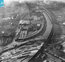
EPW024955 ENGLAND (1928). Railway viaduct and Thomas Vickers & Sons Limited, Widnes, 1928
© Copyright OpenStreetMap contributors and licensed by the OpenStreetMap Foundation. 2025. Cartography is licensed as CC BY-SA.
Nearby Images (16)
Details
| Title | [EPW024955] Railway viaduct and Thomas Vickers & Sons Limited, Widnes, 1928 |
| Reference | EPW024955 |
| Date | October-1928 |
| Link | |
| Place name | WIDNES |
| Parish | |
| District | |
| Country | ENGLAND |
| Easting / Northing | 350792, 384232 |
| Longitude / Latitude | -2.7393506226748, 53.352414364672 |
| National Grid Reference | SJ508842 |
Pins
 John W |
Monday 26th of October 2020 04:25:36 PM | |
 John W |
Monday 26th of October 2020 04:25:12 PM | |
 Ginger79 |
Saturday 28th of March 2020 05:24:03 PM | |
 Ginger79 |
Saturday 28th of March 2020 05:23:25 PM | |
 Ginger79 |
Saturday 28th of March 2020 05:19:28 PM | |
 Ginger79 |
Tuesday 30th of April 2019 10:14:42 PM | |
 Ginger79 |
Tuesday 30th of April 2019 10:14:14 PM | |
 Ginger79 |
Tuesday 30th of April 2019 10:13:24 PM |
User Comment Contributions
 Martin |
Tuesday 3rd of July 2012 05:50:07 PM |


![[EPW024955] Railway viaduct and Thomas Vickers & Sons Limited, Widnes, 1928](http://britainfromabove.org.uk/sites/all/libraries/aerofilms-images/public/100x100/EPW/024/EPW024955.jpg)
![[EPW024957] Railway viaduct and Thomas Vickers & Sons Limited, Widnes, 1928. This image has been affected by flare.](http://britainfromabove.org.uk/sites/all/libraries/aerofilms-images/public/100x100/EPW/024/EPW024957.jpg)
![[EPW024952] Railway viaduct and Thomas Vickers & Sons Limited, Widnes, 1928](http://britainfromabove.org.uk/sites/all/libraries/aerofilms-images/public/100x100/EPW/024/EPW024952.jpg)
![[EPW024956] Railway viaduct and Thomas Vickers & Sons Limited, Widnes, 1928](http://britainfromabove.org.uk/sites/all/libraries/aerofilms-images/public/100x100/EPW/024/EPW024956.jpg)
![[EAW046904] Fisons Ltd Works at the West Bank Dock Estate and the railway viaduct, Widnes, 1952. This image was marked by Aerofilms Ltd for photo editing.](http://britainfromabove.org.uk/sites/all/libraries/aerofilms-images/public/100x100/EAW/046/EAW046904.jpg)
![[EPW024951] Railway viaduct and Thomas Vickers & Sons Limited, Widnes, 1928](http://britainfromabove.org.uk/sites/all/libraries/aerofilms-images/public/100x100/EPW/024/EPW024951.jpg)
![[EAW046906] Fisons Ltd Works at the West Bank Dock Estate and the railway viaduct, Widnes, 1952. This image was marked by Aerofilms Ltd for photo editing.](http://britainfromabove.org.uk/sites/all/libraries/aerofilms-images/public/100x100/EAW/046/EAW046906.jpg)
![[EAW046905] Fisons Ltd Works at the West Bank Dock Estate and the railway viaduct, Widnes, 1952. This image was marked by Aerofilms Ltd for photo editing.](http://britainfromabove.org.uk/sites/all/libraries/aerofilms-images/public/100x100/EAW/046/EAW046905.jpg)
![[EPW024954] Railway viaduct and Thomas Vickers & Sons Limited, Widnes, 1928](http://britainfromabove.org.uk/sites/all/libraries/aerofilms-images/public/100x100/EPW/024/EPW024954.jpg)
![[EPW024958] Railway viaduct and Thomas Vickers & Sons Limited, Widnes, 1928](http://britainfromabove.org.uk/sites/all/libraries/aerofilms-images/public/100x100/EPW/024/EPW024958.jpg)
![[EAW046908] Fisons Ltd Works at the West Bank Dock Estate and the railway viaduct, Widnes, 1952. This image was marked by Aerofilms Ltd for photo editing.](http://britainfromabove.org.uk/sites/all/libraries/aerofilms-images/public/100x100/EAW/046/EAW046908.jpg)
![[EAW046909] Fisons Ltd Works at the West Bank Dock Estate and the railway viaduct, Widnes, 1952. This image was marked by Aerofilms Ltd for photo editing.](http://britainfromabove.org.uk/sites/all/libraries/aerofilms-images/public/100x100/EAW/046/EAW046909.jpg)
![[EPW024953] Railway viaduct and Thomas Vickers & Sons Limited, Widnes, 1928](http://britainfromabove.org.uk/sites/all/libraries/aerofilms-images/public/100x100/EPW/024/EPW024953.jpg)
![[EAW046907] Fisons Ltd Works at the West Bank Dock Estate and the railway viaduct, Widnes, 1952](http://britainfromabove.org.uk/sites/all/libraries/aerofilms-images/public/100x100/EAW/046/EAW046907.jpg)
![[EAW046910] Fisons Ltd Works at the West Bank Dock Estate and the railway viaduct, Widnes, 1952. This image was marked by Aerofilms Ltd for photo editing.](http://britainfromabove.org.uk/sites/all/libraries/aerofilms-images/public/100x100/EAW/046/EAW046910.jpg)
![[EAW046912] Fisons Ltd Works at the West Bank Dock Estate and environs, Widnes, 1952](http://britainfromabove.org.uk/sites/all/libraries/aerofilms-images/public/100x100/EAW/046/EAW046912.jpg)
