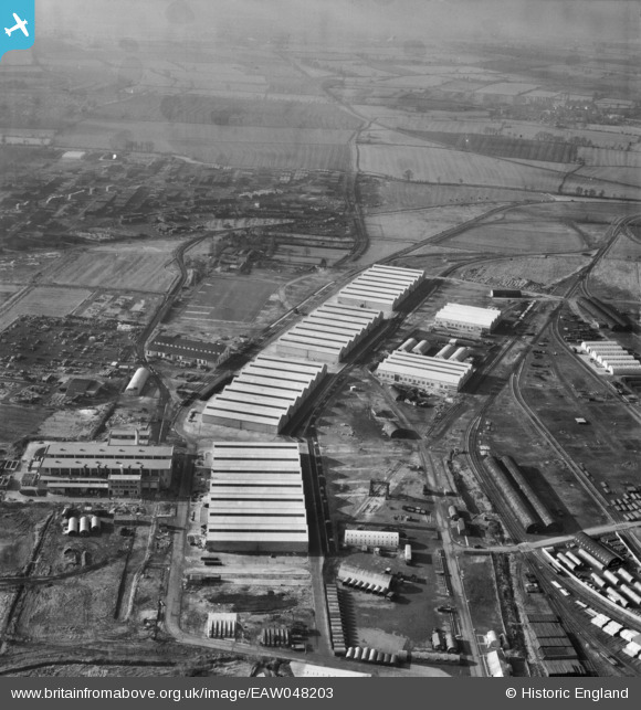
EAW048203 ENGLAND (1953). The Long Marston Supply Depot (Central Engineer Park), Long Marston, from the north-east, 1953
© Copyright OpenStreetMap contributors and licensed by the OpenStreetMap Foundation. 2024. Cartography is licensed as CC BY-SA.
Nearby Images (21)
Details
| Title | [EAW048203] The Long Marston Supply Depot (Central Engineer Park), Long Marston, from the north-east, 1953 |
| Reference | EAW048203 |
| Date | 29-January-1953 |
| Link | |
| Place name | LONG MARSTON |
| Parish | LONG MARSTON |
| District | |
| Country | ENGLAND |
| Easting / Northing | 416294, 246711 |
| Longitude / Latitude | -1.7620034072129, 52.118065388372 |
| National Grid Reference | SP163467 |
Pins
Be the first to add a comment to this image!


![[EAW048203] The Long Marston Supply Depot (Central Engineer Park), Long Marston, from the north-east, 1953](http://britainfromabove.org.uk/sites/all/libraries/aerofilms-images/public/100x100/EAW/048/EAW048203.jpg)
![[EAW039975] The Long Marston Supply Depot (Central Engineer Park) under construction, Long Marston, 1951](http://britainfromabove.org.uk/sites/all/libraries/aerofilms-images/public/100x100/EAW/039/EAW039975.jpg)
![[EAW039973] The Long Marston Supply Depot (Central Engineer Park) under construction, Long Marston, 1951](http://britainfromabove.org.uk/sites/all/libraries/aerofilms-images/public/100x100/EAW/039/EAW039973.jpg)
![[EAW048206] The Long Marston Supply Depot (Central Engineer Park), Long Marston, from the north-east, 1953](http://britainfromabove.org.uk/sites/all/libraries/aerofilms-images/public/100x100/EAW/048/EAW048206.jpg)
![[EAW048199] The Long Marston Supply Depot (Central Engineer Park), Long Marston, from the north-east, 1953](http://britainfromabove.org.uk/sites/all/libraries/aerofilms-images/public/100x100/EAW/048/EAW048199.jpg)
![[EAW042125] The Long Marston Supply Depot (Central Engineer Park) under construction, Long Marston, 1952](http://britainfromabove.org.uk/sites/all/libraries/aerofilms-images/public/100x100/EAW/042/EAW042125.jpg)
![[EAW048194] The Long Marston Supply Depot (Central Engineer Park), Long Marston, from the west, 1953. This image has been produced from a damaged negative.](http://britainfromabove.org.uk/sites/all/libraries/aerofilms-images/public/100x100/EAW/048/EAW048194.jpg)
![[EAW042128] The Long Marston Supply Depot (Central Engineer Park) under construction, Long Marston, 1952](http://britainfromabove.org.uk/sites/all/libraries/aerofilms-images/public/100x100/EAW/042/EAW042128.jpg)
![[EAW042126] The Long Marston Supply Depot (Central Engineer Park) under construction, Long Marston, 1952](http://britainfromabove.org.uk/sites/all/libraries/aerofilms-images/public/100x100/EAW/042/EAW042126.jpg)
![[EAW042121] The Long Marston Supply Depot (Central Engineer Park) under construction, Long Marston, 1952](http://britainfromabove.org.uk/sites/all/libraries/aerofilms-images/public/100x100/EAW/042/EAW042121.jpg)
![[EAW039977] The Long Marston Supply Depot (Central Engineer Park) under construction, Long Marston, 1951](http://britainfromabove.org.uk/sites/all/libraries/aerofilms-images/public/100x100/EAW/039/EAW039977.jpg)
![[EAW042123] The Long Marston Supply Depot (Central Engineer Park) under construction, Long Marston, 1952](http://britainfromabove.org.uk/sites/all/libraries/aerofilms-images/public/100x100/EAW/042/EAW042123.jpg)
![[EAW048198] The Long Marston Supply Depot (Central Engineer Park), Long Marston, from the west, 1953](http://britainfromabove.org.uk/sites/all/libraries/aerofilms-images/public/100x100/EAW/048/EAW048198.jpg)
![[EAW042122] The Long Marston Supply Depot (Central Engineer Park) under construction, Long Marston, 1952](http://britainfromabove.org.uk/sites/all/libraries/aerofilms-images/public/100x100/EAW/042/EAW042122.jpg)
![[EAW039972] The Long Marston Supply Depot (Central Engineer Park) under construction, Long Marston, 1951](http://britainfromabove.org.uk/sites/all/libraries/aerofilms-images/public/100x100/EAW/039/EAW039972.jpg)
![[EAW039979] The Long Marston Supply Depot (Central Engineer Park) under construction, Long Marston, 1951](http://britainfromabove.org.uk/sites/all/libraries/aerofilms-images/public/100x100/EAW/039/EAW039979.jpg)
![[EAW048195] The Long Marston Supply Depot (Central Engineer Park), Long Marston, 1953](http://britainfromabove.org.uk/sites/all/libraries/aerofilms-images/public/100x100/EAW/048/EAW048195.jpg)
![[EAW039980] The Long Marston Supply Depot (Central Engineer Park) under construction, Long Marston, 1951](http://britainfromabove.org.uk/sites/all/libraries/aerofilms-images/public/100x100/EAW/039/EAW039980.jpg)
![[EAW039982] The Long Marston Supply Depot (Central Engineer Park) under construction, Long Marston, 1951](http://britainfromabove.org.uk/sites/all/libraries/aerofilms-images/public/100x100/EAW/039/EAW039982.jpg)
![[EAW039983] The Long Marston Supply Depot (Central Engineer Park) under construction, Long Marston, 1951](http://britainfromabove.org.uk/sites/all/libraries/aerofilms-images/public/100x100/EAW/039/EAW039983.jpg)
![[EAW042127] The Long Marston Supply Depot (Central Engineer Park) under construction, Long Marston, 1952](http://britainfromabove.org.uk/sites/all/libraries/aerofilms-images/public/100x100/EAW/042/EAW042127.jpg)