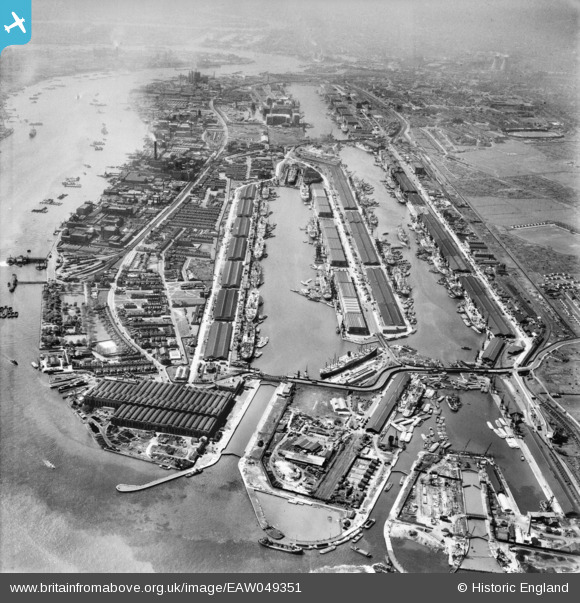
EAW049351 ENGLAND (1953). The Royal Group of Docks, North Woolwich, 1953
© Copyright OpenStreetMap contributors and licensed by the OpenStreetMap Foundation. 2025. Cartography is licensed as CC BY-SA.
Nearby Images (25)
Details
| Title | [EAW049351] The Royal Group of Docks, North Woolwich, 1953 |
| Reference | EAW049351 |
| Date | 13-May-1953 |
| Link | |
| Place name | NORTH WOOLWICH |
| Parish | |
| District | |
| Country | ENGLAND |
| Easting / Northing | 543328, 180362 |
| Longitude / Latitude | 0.065323070356968, 51.503510010315 |
| National Grid Reference | TQ433804 |
Pins
 redmist |
Tuesday 30th of June 2020 07:34:31 PM | |
 redmist |
Tuesday 30th of June 2020 07:29:30 PM | |
 redmist |
Tuesday 30th of June 2020 07:27:45 PM | |
 redmist |
Tuesday 30th of June 2020 07:25:45 PM | |
 redmist |
Tuesday 30th of June 2020 07:24:24 PM |


![[EAW049351] The Royal Group of Docks, North Woolwich, 1953](http://britainfromabove.org.uk/sites/all/libraries/aerofilms-images/public/100x100/EAW/049/EAW049351.jpg)
![[EAW000051] The King George V Dock and the Royal Albert Dock, Beckton, 1946](http://britainfromabove.org.uk/sites/all/libraries/aerofilms-images/public/100x100/EAW/000/EAW000051.jpg)
![[EAW008726] The Royal Albert Dock and the King George V Dock, North Woolwich, 1947](http://britainfromabove.org.uk/sites/all/libraries/aerofilms-images/public/100x100/EAW/008/EAW008726.jpg)
![[EAW000058] The King George V Dock and the Royal Albert Dock, Beckton, 1946. This image has been produced from a damaged negative.](http://britainfromabove.org.uk/sites/all/libraries/aerofilms-images/public/100x100/EAW/000/EAW000058.jpg)
![[EAW000054] The King George V Dock and the Royal Albert Dock, Beckton, 1946](http://britainfromabove.org.uk/sites/all/libraries/aerofilms-images/public/100x100/EAW/000/EAW000054.jpg)
![[EAW000057] The Royal Victoria Dock, the Royal Albert Dock and the King George V Dock, North Woolwich, 1946. This image was produced from a print.](http://britainfromabove.org.uk/sites/all/libraries/aerofilms-images/public/100x100/EAW/000/EAW000057.jpg)
![[EAW005289] The Royal Albert Dock, King George V Dock and environs, North Woolwich, from the south-east, 1947](http://britainfromabove.org.uk/sites/all/libraries/aerofilms-images/public/100x100/EAW/005/EAW005289.jpg)
![[EAW022357] The Royal Albert and King George V Docks, North Woolwich, 1949](http://britainfromabove.org.uk/sites/all/libraries/aerofilms-images/public/100x100/EAW/022/EAW022357.jpg)
![[EAW000050] The King George V Dock and the Royal Albert Dock, Beckton, 1946](http://britainfromabove.org.uk/sites/all/libraries/aerofilms-images/public/100x100/EAW/000/EAW000050.jpg)
![[EPW032935] The Royal Albert Dock and King George V Dock, North Woolwich, 1930](http://britainfromabove.org.uk/sites/all/libraries/aerofilms-images/public/100x100/EPW/032/EPW032935.jpg)
![[EPW032936] The Royal Albert Dock and King George V Dock, North Woolwich, 1930](http://britainfromabove.org.uk/sites/all/libraries/aerofilms-images/public/100x100/EPW/032/EPW032936.jpg)
![[EAW008722] The Royal Albert Dock and the King George V Dock, North Woolwich, 1947](http://britainfromabove.org.uk/sites/all/libraries/aerofilms-images/public/100x100/EAW/008/EAW008722.jpg)
![[EAW021703] The Royal Albert Dock and the King George V Dock, North Woolwich, 1949. This image has been produced from a print.](http://britainfromabove.org.uk/sites/all/libraries/aerofilms-images/public/100x100/EAW/021/EAW021703.jpg)
![[EPW010727] Ships moored in the Royal Albert Dock and the King George V Dock, North Woolwich, 1924. This image has been produced from a copy-negative.](http://britainfromabove.org.uk/sites/all/libraries/aerofilms-images/public/100x100/EPW/010/EPW010727.jpg)
![[EAW000055] The King George V Dock and the Royal Albert Dock, Beckton, 1946](http://britainfromabove.org.uk/sites/all/libraries/aerofilms-images/public/100x100/EAW/000/EAW000055.jpg)
![[EPW008885] King George V Dock and the Royal Albert Dock, North Woolwich, 1923](http://britainfromabove.org.uk/sites/all/libraries/aerofilms-images/public/100x100/EPW/008/EPW008885.jpg)
![[EAW008725] The Royal Albert Dock and the King George V Dock, North Woolwich, 1947](http://britainfromabove.org.uk/sites/all/libraries/aerofilms-images/public/100x100/EAW/008/EAW008725.jpg)
![[EPW021370] The Royal Albert and King George V Docks, North Woolwich, 1928](http://britainfromabove.org.uk/sites/all/libraries/aerofilms-images/public/100x100/EPW/021/EPW021370.jpg)
![[EAW005290] The Royal Albert Dock, King George V Dock and environs, North Woolwich, from the east, 1947](http://britainfromabove.org.uk/sites/all/libraries/aerofilms-images/public/100x100/EAW/005/EAW005290.jpg)
![[EPW008887] King George V Dock and the Royal Albert Dock, North Woolwich, 1923. This image has been produced from a print.](http://britainfromabove.org.uk/sites/all/libraries/aerofilms-images/public/100x100/EPW/008/EPW008887.jpg)
![[EPW032937] The Royal Albert Dock and King George V Dock, North Woolwich, 1930](http://britainfromabove.org.uk/sites/all/libraries/aerofilms-images/public/100x100/EPW/032/EPW032937.jpg)
![[EAW008723] The Royal Albert Dock and the King George V Dock, North Woolwich, 1947](http://britainfromabove.org.uk/sites/all/libraries/aerofilms-images/public/100x100/EAW/008/EAW008723.jpg)
![[EAW014133] King George V Dock and Royal Albert Dock, North Woolwich, from the east, 1948. This image has been produced from a print.](http://britainfromabove.org.uk/sites/all/libraries/aerofilms-images/public/100x100/EAW/014/EAW014133.jpg)
![[EAW008727] The Royal Albert Dock and the King George V Dock, North Woolwich, 1947](http://britainfromabove.org.uk/sites/all/libraries/aerofilms-images/public/100x100/EAW/008/EAW008727.jpg)
![[EAW022360] The Royal Docks and environs, North Woolwich, from the east, 1949](http://britainfromabove.org.uk/sites/all/libraries/aerofilms-images/public/100x100/EAW/022/EAW022360.jpg)