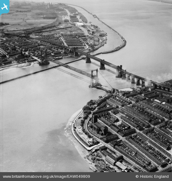
EAW049809 ENGLAND (1953). The Widnes Transporter Bridge and Runcorn Railway Bridge crossing the River Mersey and Manchester Ship Canal, Runcorn Gap, 1953
© Copyright OpenStreetMap contributors and licensed by the OpenStreetMap Foundation. 2025. Cartography is licensed as CC BY-SA.
Nearby Images (36)
Details
| Title | [EAW049809] The Widnes Transporter Bridge and Runcorn Railway Bridge crossing the River Mersey and Manchester Ship Canal, Runcorn Gap, 1953 |
| Reference | EAW049809 |
| Date | 30-May-1953 |
| Link | |
| Place name | RUNCORN GAP |
| Parish | |
| District | |
| Country | ENGLAND |
| Easting / Northing | 351111, 383594 |
| Longitude / Latitude | -2.7344594960431, 53.34670900808 |
| National Grid Reference | SJ511836 |
Pins
 Bottom Yard |
Monday 11th of November 2024 06:50:51 PM | |
 Bottom Yard |
Monday 11th of November 2024 06:46:46 PM | |
 Bottom Yard |
Monday 11th of November 2024 06:43:44 PM | |
 Bottom Yard |
Monday 11th of November 2024 06:40:52 PM | |
 Chris Kolonko |
Thursday 8th of April 2021 10:54:18 AM | |
 Ginger79 |
Saturday 20th of July 2019 06:07:31 PM |


![[EAW049809] The Widnes Transporter Bridge and Runcorn Railway Bridge crossing the River Mersey and Manchester Ship Canal, Runcorn Gap, 1953](http://britainfromabove.org.uk/sites/all/libraries/aerofilms-images/public/100x100/EAW/049/EAW049809.jpg)
![[EAW049808] The Widnes Transporter Bridge and Runcorn Railway Bridge crossing the River Mersey and Manchester Ship Canal, Runcorn Gap, 1953](http://britainfromabove.org.uk/sites/all/libraries/aerofilms-images/public/100x100/EAW/049/EAW049808.jpg)
![[EAW049804] The Widnes Transporter Bridge and Runcorn Railway Bridge crossing the River Mersey and Manchester Ship Canal, Runcorn Gap, 1953](http://britainfromabove.org.uk/sites/all/libraries/aerofilms-images/public/100x100/EAW/049/EAW049804.jpg)
![[EAW008430] Runcorn Bridge and the Widnes Transport Bridge, Runcorn Gap, 1947](http://britainfromabove.org.uk/sites/all/libraries/aerofilms-images/public/100x100/EAW/008/EAW008430.jpg)
![[EAW049815] The Widnes Transporter Bridge and Runcorn Railway Bridge crossing the River Mersey and Manchester Ship Canal, Runcorn Gap, 1953](http://britainfromabove.org.uk/sites/all/libraries/aerofilms-images/public/100x100/EAW/049/EAW049815.jpg)
![[EAW049813] The Widnes Transporter Bridge and Runcorn Railway Bridge crossing the River Mersey and Manchester Ship Canal, Runcorn Gap, 1953](http://britainfromabove.org.uk/sites/all/libraries/aerofilms-images/public/100x100/EAW/049/EAW049813.jpg)
![[EAW044937] The Runcorn Railway Bridge and Widnes Transporter Bridge, Widnes, 1952](http://britainfromabove.org.uk/sites/all/libraries/aerofilms-images/public/100x100/EAW/044/EAW044937.jpg)
![[EAW044941] The Runcorn Railway Bridge, Widnes Transporter Bridge and environs, Widnes, 1952](http://britainfromabove.org.uk/sites/all/libraries/aerofilms-images/public/100x100/EAW/044/EAW044941.jpg)
![[EAW049805] The Widnes Transporter Bridge and Runcorn Railway Bridge crossing the River Mersey and Manchester Ship Canal, Runcorn Gap, 1953](http://britainfromabove.org.uk/sites/all/libraries/aerofilms-images/public/100x100/EAW/049/EAW049805.jpg)
![[EAW049807] The Widnes Transporter Bridge and Runcorn Railway Bridge crossing the River Mersey and Manchester Ship Canal, Runcorn Gap, 1953](http://britainfromabove.org.uk/sites/all/libraries/aerofilms-images/public/100x100/EAW/049/EAW049807.jpg)
![[EAW044943] The Runcorn Railway Bridge and Widnes Transporter Bridge, Widnes, 1952](http://britainfromabove.org.uk/sites/all/libraries/aerofilms-images/public/100x100/EAW/044/EAW044943.jpg)
![[EAW049818] The Widnes Transporter Bridge and Runcorn Railway Bridge crossing the River Mersey and Manchester Ship Canal, Runcorn Gap, 1953](http://britainfromabove.org.uk/sites/all/libraries/aerofilms-images/public/100x100/EAW/049/EAW049818.jpg)
![[EPW005875] Runcorn Bridge and the Widnes Transporter Bridge, Runcorn, from the south-west, 1921. This image has been produced from a copy-negative.](http://britainfromabove.org.uk/sites/all/libraries/aerofilms-images/public/100x100/EPW/005/EPW005875.jpg)
![[EAW049814] The Widnes Transporter Bridge and Runcorn Railway Bridge crossing the River Mersey and Manchester Ship Canal, Runcorn Gap, 1953](http://britainfromabove.org.uk/sites/all/libraries/aerofilms-images/public/100x100/EAW/049/EAW049814.jpg)
![[EAW008431] Runcorn Bridge and the Widnes Transport Bridge, Runcorn Gap, 1947](http://britainfromabove.org.uk/sites/all/libraries/aerofilms-images/public/100x100/EAW/008/EAW008431.jpg)
![[EAW005676] Runcorn Bridge and the Widnes Transporter Bridge, Runcorn Gap, 1947](http://britainfromabove.org.uk/sites/all/libraries/aerofilms-images/public/100x100/EAW/005/EAW005676.jpg)
![[EAW044940] The Runcorn Railway Bridge and Widnes Transporter Bridge, Widnes, 1952](http://britainfromabove.org.uk/sites/all/libraries/aerofilms-images/public/100x100/EAW/044/EAW044940.jpg)
![[EAW049803] The Widnes Transporter Bridge and Runcorn Railway Bridge crossing the River Mersey and Manchester Ship Canal, Runcorn Gap, 1953](http://britainfromabove.org.uk/sites/all/libraries/aerofilms-images/public/100x100/EAW/049/EAW049803.jpg)
![[EAW049806] The Widnes Transporter Bridge and Runcorn Railway Bridge crossing the River Mersey and Manchester Ship Canal, Runcorn Gap, 1953](http://britainfromabove.org.uk/sites/all/libraries/aerofilms-images/public/100x100/EAW/049/EAW049806.jpg)
![[EAW044938] The Runcorn Railway Bridge and Widnes Transporter Bridge, Runcorn, 1952](http://britainfromabove.org.uk/sites/all/libraries/aerofilms-images/public/100x100/EAW/044/EAW044938.jpg)
![[EPW018913] The Railway Bridge and Transporter Bridge over the River Mersey, Runcorn Gap, 1927](http://britainfromabove.org.uk/sites/all/libraries/aerofilms-images/public/100x100/EPW/018/EPW018913.jpg)
![[EAW049798] The Widnes Transporter Bridge and Runcorn Railway Bridge crossing the River Mersey and Manchester Ship Canal, Runcorn Gap, 1953](http://britainfromabove.org.uk/sites/all/libraries/aerofilms-images/public/100x100/EAW/049/EAW049798.jpg)
![[EAW049801] The Widnes Transporter Bridge and Runcorn Railway Bridge crossing the River Mersey and Manchester Ship Canal, Runcorn Gap, 1953](http://britainfromabove.org.uk/sites/all/libraries/aerofilms-images/public/100x100/EAW/049/EAW049801.jpg)
![[EAW049816] The Widnes Transporter Bridge and Runcorn Railway Bridge crossing the River Mersey and Manchester Ship Canal, Runcorn Gap, 1953](http://britainfromabove.org.uk/sites/all/libraries/aerofilms-images/public/100x100/EAW/049/EAW049816.jpg)
![[EAW049800] The Widnes Transporter Bridge and Runcorn Railway Bridge crossing the River Mersey and Manchester Ship Canal, Runcorn Gap, 1953](http://britainfromabove.org.uk/sites/all/libraries/aerofilms-images/public/100x100/EAW/049/EAW049800.jpg)
![[EAW044939] The Runcorn Railway Bridge, Widnes Transporter Bridge and environs, Runcorn, 1952](http://britainfromabove.org.uk/sites/all/libraries/aerofilms-images/public/100x100/EAW/044/EAW044939.jpg)
![[EAW044942] The Runcorn Railway Bridge, Widnes Transporter Bridge and environs, Runcorn, 1952](http://britainfromabove.org.uk/sites/all/libraries/aerofilms-images/public/100x100/EAW/044/EAW044942.jpg)
![[EAW049812] The Widnes Transporter Bridge and Runcorn Railway Bridge crossing the River Mersey and Manchester Ship Canal, Runcorn Gap, 1953](http://britainfromabove.org.uk/sites/all/libraries/aerofilms-images/public/100x100/EAW/049/EAW049812.jpg)
![[EAW005675] Runcorn Bridge and the Widnes Transporter Bridge, Runcorn Gap, 1947](http://britainfromabove.org.uk/sites/all/libraries/aerofilms-images/public/100x100/EAW/005/EAW005675.jpg)
![[EAW049817] The Widnes Transporter Bridge and Runcorn Railway Bridge crossing the River Mersey and Manchester Ship Canal, Runcorn Gap, 1953](http://britainfromabove.org.uk/sites/all/libraries/aerofilms-images/public/100x100/EAW/049/EAW049817.jpg)
![[EPW018885] St Mary's Church, Widnes, 1927. This image has been produced from a copy-negative.](http://britainfromabove.org.uk/sites/all/libraries/aerofilms-images/public/100x100/EPW/018/EPW018885.jpg)
![[EAW049799] The Widnes Transporter Bridge and Runcorn Railway Bridge crossing the River Mersey and Manchester Ship Canal, Runcorn Gap, 1953](http://britainfromabove.org.uk/sites/all/libraries/aerofilms-images/public/100x100/EAW/049/EAW049799.jpg)
![[EAW049797] The Widnes Transporter Bridge and Runcorn Railway Bridge crossing the River Mersey and Manchester Ship Canal, Runcorn Gap, 1953](http://britainfromabove.org.uk/sites/all/libraries/aerofilms-images/public/100x100/EAW/049/EAW049797.jpg)
![[EAW049802] The Widnes Transporter Bridge and Runcorn Railway Bridge crossing the River Mersey and Manchester Ship Canal, Runcorn Gap, 1953](http://britainfromabove.org.uk/sites/all/libraries/aerofilms-images/public/100x100/EAW/049/EAW049802.jpg)
![[EPW014297] West Bank Power Station, Widnes, 1925. This image has been produced from a copy-negative.](http://britainfromabove.org.uk/sites/all/libraries/aerofilms-images/public/100x100/EPW/014/EPW014297.jpg)
![[EPW014298] Runcorn Bridge and the Widnes Transporter Bridge, Runcorn, 1925. This image has been produced from a copy-negative.](http://britainfromabove.org.uk/sites/all/libraries/aerofilms-images/public/100x100/EPW/014/EPW014298.jpg)
