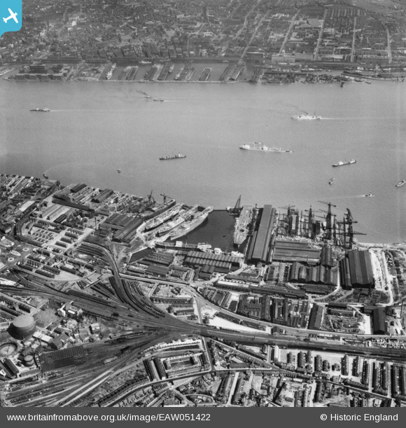
EAW051422 ENGLAND (1953). Cammell Laird's Shipbuilding and Engineering Works and environs, Birkenhead, 1953
© Copyright OpenStreetMap contributors and licensed by the OpenStreetMap Foundation. 2025. Cartography is licensed as CC BY-SA.
Nearby Images (13)
Details
| Title | [EAW051422] Cammell Laird's Shipbuilding and Engineering Works and environs, Birkenhead, 1953 |
| Reference | EAW051422 |
| Date | 12-August-1953 |
| Link | |
| Place name | BIRKENHEAD |
| Parish | |
| District | |
| Country | ENGLAND |
| Easting / Northing | 333105, 388253 |
| Longitude / Latitude | -3.0059101470468, 53.386614338705 |
| National Grid Reference | SJ331883 |
Pins
 Vulcanicity |
Monday 8th of July 2024 01:41:44 PM | |
 beast66606 |
Sunday 23rd of November 2014 10:49:20 AM | |
 beast66606 |
Sunday 23rd of November 2014 10:48:53 AM |


![[EAW051422] Cammell Laird's Shipbuilding and Engineering Works and environs, Birkenhead, 1953](http://britainfromabove.org.uk/sites/all/libraries/aerofilms-images/public/100x100/EAW/051/EAW051422.jpg)
![[EAW030641] The Cammell Laird Shipbuilding and Engineering Works, Birkenhead, 1950](http://britainfromabove.org.uk/sites/all/libraries/aerofilms-images/public/100x100/EAW/030/EAW030641.jpg)
![[EAW029264] Cammell Laird and Co Ltd Shipbuilding and Engineering Works and the Graving Docks to the north of the Outer Basin, Birkenhead, 1950. This image was marked by Aerofilms Ltd for photo editing.](http://britainfromabove.org.uk/sites/all/libraries/aerofilms-images/public/100x100/EAW/029/EAW029264.jpg)
![[EAW029270] Cammell Laird and Co Ltd Shipbuilding and Engineering Works and environs, Birkenhead, 1950. This image was marked by Aerofilms Ltd for photo editing.](http://britainfromabove.org.uk/sites/all/libraries/aerofilms-images/public/100x100/EAW/029/EAW029270.jpg)
![[EAW030640] The Cammell Laird Shipbuilding and Engineering Works, Birkenhead, 1950](http://britainfromabove.org.uk/sites/all/libraries/aerofilms-images/public/100x100/EAW/030/EAW030640.jpg)
![[EAW030649] The Cammell Laird Shipbuilding and Engineering Works, Birkenhead, 1950](http://britainfromabove.org.uk/sites/all/libraries/aerofilms-images/public/100x100/EAW/030/EAW030649.jpg)
![[EAW029266] Cammell Laird and Co Ltd Shipbuilding and Engineering Works and environs, Birkenhead, 1950](http://britainfromabove.org.uk/sites/all/libraries/aerofilms-images/public/100x100/EAW/029/EAW029266.jpg)
![[EAW001718] Outer Basin and Graving Docks of Cammell Laird's Shipbuilders Ltd, Birkenhead, 1946](http://britainfromabove.org.uk/sites/all/libraries/aerofilms-images/public/100x100/EAW/001/EAW001718.jpg)
![[EAW030647] The Cammell Laird Shipbuilding and Engineering Works, Birkenhead, 1950](http://britainfromabove.org.uk/sites/all/libraries/aerofilms-images/public/100x100/EAW/030/EAW030647.jpg)
![[EAW028439] Cammell Laird's Shipbuilding and Engineering Works and King's Square, Birkenhead, 1950](http://britainfromabove.org.uk/sites/all/libraries/aerofilms-images/public/100x100/EAW/028/EAW028439.jpg)
![[EAW030638] The Cammell Laird Shipbuilding and Engineering Works, Birkenhead, 1950](http://britainfromabove.org.uk/sites/all/libraries/aerofilms-images/public/100x100/EAW/030/EAW030638.jpg)
![[EAW029265] Cammell Laird and Co Ltd Shipbuilding and Engineering Works and the Graving Docks to the north of the Outer Basin, Birkenhead, 1950. This image was marked by Aerofilms Ltd for photo editing.](http://britainfromabove.org.uk/sites/all/libraries/aerofilms-images/public/100x100/EAW/029/EAW029265.jpg)
![[EAW051427] Cammell Laird's Shipbuilding and Engineering Works and environs, Birkenhead, 1953](http://britainfromabove.org.uk/sites/all/libraries/aerofilms-images/public/100x100/EAW/051/EAW051427.jpg)