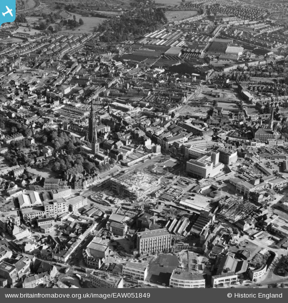
EAW051849 ENGLAND (1953). Broadgate and the city centre, Coventry, 1953
© Copyright OpenStreetMap contributors and licensed by the OpenStreetMap Foundation. 2025. Cartography is licensed as CC BY-SA.
Nearby Images (30)
Details
| Title | [EAW051849] Broadgate and the city centre, Coventry, 1953 |
| Reference | EAW051849 |
| Date | 1-September-1953 |
| Link | |
| Place name | COVENTRY |
| Parish | |
| District | |
| Country | ENGLAND |
| Easting / Northing | 433471, 278963 |
| Longitude / Latitude | -1.5079172366317, 52.40727019406 |
| National Grid Reference | SP335790 |
Pins
Be the first to add a comment to this image!


![[EAW051849] Broadgate and the city centre, Coventry, 1953](http://britainfromabove.org.uk/sites/all/libraries/aerofilms-images/public/100x100/EAW/051/EAW051849.jpg)
![[EAW024985] Broadgate, Coventry, 1949](http://britainfromabove.org.uk/sites/all/libraries/aerofilms-images/public/100x100/EAW/024/EAW024985.jpg)
![[EAW051850] Broadgate and the city centre, Coventry, 1953](http://britainfromabove.org.uk/sites/all/libraries/aerofilms-images/public/100x100/EAW/051/EAW051850.jpg)
![[EPW001190] The city centre, Coventry, 1920. This image has been produced from a copy-negative.](http://britainfromabove.org.uk/sites/all/libraries/aerofilms-images/public/100x100/EPW/001/EPW001190.jpg)
![[EAW001831] The Ruined Cathedral Church of St Michael and the bomb damaged city centre, Coventry, 1946](http://britainfromabove.org.uk/sites/all/libraries/aerofilms-images/public/100x100/EAW/001/EAW001831.jpg)
![[EAW024984] Holy Trinity Church, the Ruined Cathedral Church of St Michael and Broadgate, Coventry, from the north-west, 1949](http://britainfromabove.org.uk/sites/all/libraries/aerofilms-images/public/100x100/EAW/024/EAW024984.jpg)
![[EAW031598] The city centre, Coventry, 1950](http://britainfromabove.org.uk/sites/all/libraries/aerofilms-images/public/100x100/EAW/031/EAW031598.jpg)
![[EAW001835] The Ruined Cathedral Church of St Michael, Holy Trinity Church and the bomb damaged city centre, Coventry, 1946](http://britainfromabove.org.uk/sites/all/libraries/aerofilms-images/public/100x100/EAW/001/EAW001835.jpg)
![[EAW051848] Broadgate and the city centre, Coventry, 1953](http://britainfromabove.org.uk/sites/all/libraries/aerofilms-images/public/100x100/EAW/051/EAW051848.jpg)
![[EAW001829] The Ruined Cathedral Church of St Michael, Coventry, 1946](http://britainfromabove.org.uk/sites/all/libraries/aerofilms-images/public/100x100/EAW/001/EAW001829.jpg)
![[EAW030282] The city centre, Coventry, 1950](http://britainfromabove.org.uk/sites/all/libraries/aerofilms-images/public/100x100/EAW/030/EAW030282.jpg)
![[EAW051852] Broadgate and the city centre, Coventry, 1953](http://britainfromabove.org.uk/sites/all/libraries/aerofilms-images/public/100x100/EAW/051/EAW051852.jpg)
![[EAW024986] The Ruined Cathedral Church of St Michael, Coventry, 1949](http://britainfromabove.org.uk/sites/all/libraries/aerofilms-images/public/100x100/EAW/024/EAW024986.jpg)
![[EAW051846] Broadgate and the city centre, Coventry, 1953](http://britainfromabove.org.uk/sites/all/libraries/aerofilms-images/public/100x100/EAW/051/EAW051846.jpg)
![[EAW024987] The Ruined Cathedral Church of St Michael and Holy Trinity Church, Coventry, from the east, 1949](http://britainfromabove.org.uk/sites/all/libraries/aerofilms-images/public/100x100/EAW/024/EAW024987.jpg)
![[EAW001830] The Ruined Cathedral Church of St Michael and the bomb damaged city centre, Coventry, 1946](http://britainfromabove.org.uk/sites/all/libraries/aerofilms-images/public/100x100/EAW/001/EAW001830.jpg)
![[EAW024988] The Empire Theatre, Broadgate and Holy Trinity Church, Coventry, from the south-west, 1949](http://britainfromabove.org.uk/sites/all/libraries/aerofilms-images/public/100x100/EAW/024/EAW024988.jpg)
![[EAW030281] The city centre, Coventry, 1950](http://britainfromabove.org.uk/sites/all/libraries/aerofilms-images/public/100x100/EAW/030/EAW030281.jpg)
![[EAW001833] Barrack Square Market, Hertford Street and Christ Church, Coventry, 1946](http://britainfromabove.org.uk/sites/all/libraries/aerofilms-images/public/100x100/EAW/001/EAW001833.jpg)
![[EAW051853] Trinity Street, Priroy Street and the city centre, Coventry, 1953](http://britainfromabove.org.uk/sites/all/libraries/aerofilms-images/public/100x100/EAW/051/EAW051853.jpg)
![[EAW051845] Corporation Street, Broadgate and the city centre, Coventry, 1953](http://britainfromabove.org.uk/sites/all/libraries/aerofilms-images/public/100x100/EAW/051/EAW051845.jpg)
![[EAW030280] The city centre, Coventry, 1950](http://britainfromabove.org.uk/sites/all/libraries/aerofilms-images/public/100x100/EAW/030/EAW030280.jpg)
![[EPW061111] The city centre, Coventry, 1939](http://britainfromabove.org.uk/sites/all/libraries/aerofilms-images/public/100x100/EPW/061/EPW061111.jpg)
![[EAW001834] The bomb damaged city centre, Coventry, 1946](http://britainfromabove.org.uk/sites/all/libraries/aerofilms-images/public/100x100/EAW/001/EAW001834.jpg)
![[EPW053109] The city centre, Coventry, 1937](http://britainfromabove.org.uk/sites/all/libraries/aerofilms-images/public/100x100/EPW/053/EPW053109.jpg)
![[EAW001832] Barrack Square Market, Corporation Street and the bomb damaged city centre, Coventry, 1946](http://britainfromabove.org.uk/sites/all/libraries/aerofilms-images/public/100x100/EAW/001/EAW001832.jpg)
![[EPW012041] The city centre, Coventry, 1924. This image has been produced from a copy-negative.](http://britainfromabove.org.uk/sites/all/libraries/aerofilms-images/public/100x100/EPW/012/EPW012041.jpg)
![[EAW001828] Corporation Street and Cross Cheaping, Coventry, 1946](http://britainfromabove.org.uk/sites/all/libraries/aerofilms-images/public/100x100/EAW/001/EAW001828.jpg)
![[EPW053103] The city centre, Coventry, 1937](http://britainfromabove.org.uk/sites/all/libraries/aerofilms-images/public/100x100/EPW/053/EPW053103.jpg)
![[EAW051851] Hales Street, Priory Street and environs, Coventry, 1953](http://britainfromabove.org.uk/sites/all/libraries/aerofilms-images/public/100x100/EAW/051/EAW051851.jpg)