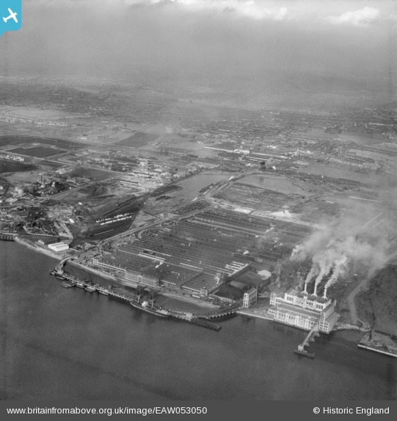
EAW053050 ENGLAND (1953). The Ford Motor Car Manufactory, Dagenham, from the south-east, 1953
© Copyright OpenStreetMap contributors and licensed by the OpenStreetMap Foundation. 2025. Cartography is licensed as CC BY-SA.
Nearby Images (48)
Details
| Title | [EAW053050] The Ford Motor Car Manufactory, Dagenham, from the south-east, 1953 |
| Reference | EAW053050 |
| Date | 24-December-1953 |
| Link | |
| Place name | DAGENHAM |
| Parish | |
| District | |
| Country | ENGLAND |
| Easting / Northing | 549616, 181493 |
| Longitude / Latitude | 0.15634405641297, 51.512043502602 |
| National Grid Reference | TQ496815 |
Pins
Be the first to add a comment to this image!


![[EAW053050] The Ford Motor Car Manufactory, Dagenham, from the south-east, 1953](http://britainfromabove.org.uk/sites/all/libraries/aerofilms-images/public/100x100/EAW/053/EAW053050.jpg)
![[EPW046927] The Ford Motor Company Works, Dagenham, from the south, 1935](http://britainfromabove.org.uk/sites/all/libraries/aerofilms-images/public/100x100/EPW/046/EPW046927.jpg)
![[EPW046925] The Ford Motor Company Works, Dagenham, 1935](http://britainfromabove.org.uk/sites/all/libraries/aerofilms-images/public/100x100/EPW/046/EPW046925.jpg)
![[EPW046932] The Ford Motor Company Works, Dagenham, from the south-west, 1935](http://britainfromabove.org.uk/sites/all/libraries/aerofilms-images/public/100x100/EPW/046/EPW046932.jpg)
![[EAW022769] The Ford Motor Company Works, Dagenham, from the south, 1949](http://britainfromabove.org.uk/sites/all/libraries/aerofilms-images/public/100x100/EAW/022/EAW022769.jpg)
![[EAW029508] The Ford Motor Company Works, Dagenham, 1950. This image was marked by Aerofilms Ltd for photo editing.](http://britainfromabove.org.uk/sites/all/libraries/aerofilms-images/public/100x100/EAW/029/EAW029508.jpg)
![[EAW000071] The Ford Motor Car Manufactory, Dagenham, 1946](http://britainfromabove.org.uk/sites/all/libraries/aerofilms-images/public/100x100/EAW/000/EAW000071.jpg)
![[EPW046937] The Ford Motor Company Works, Dagenham, 1935](http://britainfromabove.org.uk/sites/all/libraries/aerofilms-images/public/100x100/EPW/046/EPW046937.jpg)
![[EAW022765] The Ford Motor Company Works, Dagenham, 1949. This image has been produced from a print marked by Aerofilms Ltd for photo editing.](http://britainfromabove.org.uk/sites/all/libraries/aerofilms-images/public/100x100/EAW/022/EAW022765.jpg)
![[EPW046924] The Ford Motor Company Works, Dagenham, from the south-west, 1935](http://britainfromabove.org.uk/sites/all/libraries/aerofilms-images/public/100x100/EPW/046/EPW046924.jpg)
![[EPW046920] The Ford Motor Company Works, Dagenham, from the south-west, 1935](http://britainfromabove.org.uk/sites/all/libraries/aerofilms-images/public/100x100/EPW/046/EPW046920.jpg)
![[EAW022772] The Ford Motor Company Works, Dagenham, 1949](http://britainfromabove.org.uk/sites/all/libraries/aerofilms-images/public/100x100/EAW/022/EAW022772.jpg)
![[EPW062034] The Ford Motor Car Manufactory, Dagenham, 1939](http://britainfromabove.org.uk/sites/all/libraries/aerofilms-images/public/100x100/EPW/062/EPW062034.jpg)
![[EAW022771] The Ford Motor Company Works, Dagenham, 1949](http://britainfromabove.org.uk/sites/all/libraries/aerofilms-images/public/100x100/EAW/022/EAW022771.jpg)
![[EPW055197] The Ford Motor Car Manufactory, Dagenham, 1937](http://britainfromabove.org.uk/sites/all/libraries/aerofilms-images/public/100x100/EPW/055/EPW055197.jpg)
![[EPW046933] The Ford Motor Company Works, Dagenham, from the south-west, 1935](http://britainfromabove.org.uk/sites/all/libraries/aerofilms-images/public/100x100/EPW/046/EPW046933.jpg)
![[EPW060998] The Ford Motor Car Manufactory, Dagenham, from the south, 1939](http://britainfromabove.org.uk/sites/all/libraries/aerofilms-images/public/100x100/EPW/060/EPW060998.jpg)
![[EAW053203] The Ford Motor Company Works, Dagenham, 1954](http://britainfromabove.org.uk/sites/all/libraries/aerofilms-images/public/100x100/EAW/053/EAW053203.jpg)
![[EPW055149] The Ford Motor Car Manufactory, Dagenham, 1937. This image has been produced from a copy-negative.](http://britainfromabove.org.uk/sites/all/libraries/aerofilms-images/public/100x100/EPW/055/EPW055149.jpg)
![[EPW046936] The Ford Motor Company Works, Dagenham, 1935](http://britainfromabove.org.uk/sites/all/libraries/aerofilms-images/public/100x100/EPW/046/EPW046936.jpg)
![[EPW046916] The Ford Motor Company Works, Dagenham, from the south-west, 1935](http://britainfromabove.org.uk/sites/all/libraries/aerofilms-images/public/100x100/EPW/046/EPW046916.jpg)
![[EPW062035] The Ford Motor Car Manufactory and environs, Dagenham, from the south, 1939](http://britainfromabove.org.uk/sites/all/libraries/aerofilms-images/public/100x100/EPW/062/EPW062035.jpg)
![[EPW046919] The Ford Motor Company Works, Dagenham, 1935](http://britainfromabove.org.uk/sites/all/libraries/aerofilms-images/public/100x100/EPW/046/EPW046919.jpg)
![[EPW055160] The Ford Motor Car Manufactory, Dagenham, 1937](http://britainfromabove.org.uk/sites/all/libraries/aerofilms-images/public/100x100/EPW/055/EPW055160.jpg)
![[EAW029509] The Ford Motor Company Works, Dagenham, 1950. This image was marked by Aerofilms Ltd for photo editing.](http://britainfromabove.org.uk/sites/all/libraries/aerofilms-images/public/100x100/EAW/029/EAW029509.jpg)
![[EPW046917] The Ford Motor Company Works, Dagenham, from the south-west, 1935](http://britainfromabove.org.uk/sites/all/libraries/aerofilms-images/public/100x100/EPW/046/EPW046917.jpg)
![[EPW046923] The Ford Motor Company Works, Dagenham, 1935](http://britainfromabove.org.uk/sites/all/libraries/aerofilms-images/public/100x100/EPW/046/EPW046923.jpg)
![[EPW046926] The Ford Motor Company Works, Dagenham, from the south-west, 1935](http://britainfromabove.org.uk/sites/all/libraries/aerofilms-images/public/100x100/EPW/046/EPW046926.jpg)
![[EPW055164] The Ford Motor Car Manufactory, Dagenham, 1937](http://britainfromabove.org.uk/sites/all/libraries/aerofilms-images/public/100x100/EPW/055/EPW055164.jpg)
![[EPW037317] The Ford Motor Company Works, Dagenham, 1932](http://britainfromabove.org.uk/sites/all/libraries/aerofilms-images/public/100x100/EPW/037/EPW037317.jpg)
![[EAW029510] The Ford Motor Company Works, Dagenham, 1950. This image was marked by Aerofilms Ltd for photo editing.](http://britainfromabove.org.uk/sites/all/libraries/aerofilms-images/public/100x100/EAW/029/EAW029510.jpg)
![[EPW046930] The Ford Motor Company Works, Dagenham, from the south, 1935](http://britainfromabove.org.uk/sites/all/libraries/aerofilms-images/public/100x100/EPW/046/EPW046930.jpg)
![[EAW022768] The Ford Motor Company Works, Dagenham, 1949. This image has been produced from a print marked by Aerofilms Ltd for photo editing.](http://britainfromabove.org.uk/sites/all/libraries/aerofilms-images/public/100x100/EAW/022/EAW022768.jpg)
![[EAW022773] The Ford Motor Company Works, Dagenham, 1949](http://britainfromabove.org.uk/sites/all/libraries/aerofilms-images/public/100x100/EAW/022/EAW022773.jpg)
![[EPW032052] The Ford Motor Company Works under construction, Dagenham, 1930. This image has been produced from a copy-negative.](http://britainfromabove.org.uk/sites/all/libraries/aerofilms-images/public/100x100/EPW/032/EPW032052.jpg)
![[EPW037317A] The Ford Motor Company Works, Dagenham, 1932](http://britainfromabove.org.uk/sites/all/libraries/aerofilms-images/public/100x100/EPW/037/EPW037317A.jpg)
![[EPW055163] The Ford Motor Car Manufactory, Dagenham, 1937](http://britainfromabove.org.uk/sites/all/libraries/aerofilms-images/public/100x100/EPW/055/EPW055163.jpg)
![[EAW053046] Coal barges on the River Thames in front of the Ford Motor Car Manufactory, Dagenham, 1953](http://britainfromabove.org.uk/sites/all/libraries/aerofilms-images/public/100x100/EAW/053/EAW053046.jpg)
![[EAW021712] The Ford Motor Car Manufactory and environs, Dagenham, 1949. This image has been produced from a print.](http://britainfromabove.org.uk/sites/all/libraries/aerofilms-images/public/100x100/EAW/021/EAW021712.jpg)
![[EPW061002] The Ford Motor Car Manufactory, Dagenham, 1939](http://britainfromabove.org.uk/sites/all/libraries/aerofilms-images/public/100x100/EPW/061/EPW061002.jpg)
![[EAW000074] The Ford Motor Car Manufactory, Dagenham, 1946](http://britainfromabove.org.uk/sites/all/libraries/aerofilms-images/public/100x100/EAW/000/EAW000074.jpg)
![[EAW053043] Coal barges on the River Thames in front of the Ford Motor Car Manufactory, Dagenham, from the south-east, 1953](http://britainfromabove.org.uk/sites/all/libraries/aerofilms-images/public/100x100/EAW/053/EAW053043.jpg)
![[EPW055198] The Ford Motor Car Manufactory, Dagenham, 1937](http://britainfromabove.org.uk/sites/all/libraries/aerofilms-images/public/100x100/EPW/055/EPW055198.jpg)
![[EPW055162] The Ford Motor Car Manufactory, Dagenham, 1937](http://britainfromabove.org.uk/sites/all/libraries/aerofilms-images/public/100x100/EPW/055/EPW055162.jpg)
![[EPW046921] The Ford Motor Company Works, Dagenham, from the south-west, 1935](http://britainfromabove.org.uk/sites/all/libraries/aerofilms-images/public/100x100/EPW/046/EPW046921.jpg)
![[EAW053042] Coal barges on the River Thames in front of the Ford Motor Car Manufactory, Dagenham, from the south, 1953](http://britainfromabove.org.uk/sites/all/libraries/aerofilms-images/public/100x100/EAW/053/EAW053042.jpg)
![[EPW046922] The Ford Motor Company Works, Dagenham, from the south-west, 1935](http://britainfromabove.org.uk/sites/all/libraries/aerofilms-images/public/100x100/EPW/046/EPW046922.jpg)
![[EPW046915] The Ford Motor Company Works, Dagenham, from the north-west, 1935](http://britainfromabove.org.uk/sites/all/libraries/aerofilms-images/public/100x100/EPW/046/EPW046915.jpg)