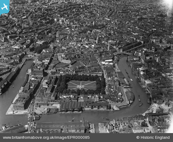
EPR000085 ENGLAND (1934). Queen Square and the city centre, Bristol, 1934
© Copyright OpenStreetMap contributors and licensed by the OpenStreetMap Foundation. 2025. Cartography is licensed as CC BY-SA.
Nearby Images (20)
Details
| Title | [EPR000085] Queen Square and the city centre, Bristol, 1934 |
| Reference | EPR000085 |
| Date | 4-July-1934 |
| Link | |
| Place name | BRISTOL |
| Parish | |
| District | |
| Country | ENGLAND |
| Easting / Northing | 358807, 172726 |
| Longitude / Latitude | -2.5928807485972, 51.451528407029 |
| National Grid Reference | ST588727 |
Pins
 TarzeyMeese |
Wednesday 9th of December 2020 07:56:54 PM | |
 TarzeyMeese |
Wednesday 9th of December 2020 07:37:52 PM | |
 MildBunch |
Wednesday 18th of February 2015 03:21:19 PM | |
 MildBunch |
Wednesday 18th of February 2015 03:20:26 PM | |
 MildBunch |
Wednesday 18th of February 2015 03:20:10 PM | |
 Chelsea61 |
Monday 17th of November 2014 06:24:33 PM | |
 Chelsea61 |
Monday 17th of November 2014 06:24:06 PM | |
 Chelsea61 |
Monday 17th of November 2014 06:23:26 PM | |
 Chelsea61 |
Monday 17th of November 2014 06:22:58 PM | |
 Chelsea61 |
Monday 17th of November 2014 06:22:17 PM | |
 Chelsea61 |
Monday 17th of November 2014 06:21:59 PM | |
 Chelsea61 |
Monday 17th of November 2014 06:21:36 PM | |
 Chelsea61 |
Monday 17th of November 2014 06:21:02 PM | |
 Chelsea61 |
Monday 17th of November 2014 06:20:38 PM | |
 Chelsea61 |
Monday 17th of November 2014 06:20:18 PM |


![[EPR000085] Queen Square and the city centre, Bristol, 1934](http://britainfromabove.org.uk/sites/all/libraries/aerofilms-images/public/100x100/EPR/000/EPR000085.jpg)
![[EAW026794] The city centre, Bristol, from the south-west, 1949](http://britainfromabove.org.uk/sites/all/libraries/aerofilms-images/public/100x100/EAW/026/EAW026794.jpg)
![[EPW033503] Queen Square and environs, Bristol, 1930](http://britainfromabove.org.uk/sites/all/libraries/aerofilms-images/public/100x100/EPW/033/EPW033503.jpg)
![[EAW026795] Queen Square and the city centre, Bristol, from the south-west, 1949](http://britainfromabove.org.uk/sites/all/libraries/aerofilms-images/public/100x100/EAW/026/EAW026795.jpg)
![[EPR000072] Baldwin Street, Bristol Bridge and the city centre, Bristol, 1934](http://britainfromabove.org.uk/sites/all/libraries/aerofilms-images/public/100x100/EPR/000/EPR000072.jpg)
![[EPW047089] St Nicholas's Church, Colston Avenue and Baldwin Street, Bristol, 1935](http://britainfromabove.org.uk/sites/all/libraries/aerofilms-images/public/100x100/EPW/047/EPW047089.jpg)
![[EPW008823] Redcliffe Wharf, Bristol, 1923](http://britainfromabove.org.uk/sites/all/libraries/aerofilms-images/public/100x100/EPW/008/EPW008823.jpg)
![[EPW008826] Redcliffe Wharf and Queen Square, Bristol, 1923](http://britainfromabove.org.uk/sites/all/libraries/aerofilms-images/public/100x100/EPW/008/EPW008826.jpg)
![[EPW012022] The Floating Harbour, Bristol, 1924. This image has been produced from a print.](http://britainfromabove.org.uk/sites/all/libraries/aerofilms-images/public/100x100/EPW/012/EPW012022.jpg)
![[EPW008825] Redcliffe Wharf, Bristol, 1923](http://britainfromabove.org.uk/sites/all/libraries/aerofilms-images/public/100x100/EPW/008/EPW008825.jpg)
![[EPW008819] Redcliffe Wharf, Bristol, 1923](http://britainfromabove.org.uk/sites/all/libraries/aerofilms-images/public/100x100/EPW/008/EPW008819.jpg)
![[EPW008820] Redcliffe Wharf and Queen Square, Bristol, 1923](http://britainfromabove.org.uk/sites/all/libraries/aerofilms-images/public/100x100/EPW/008/EPW008820.jpg)
![[EPW008826A] Redcliffe Wharf, Bristol, 1923](http://britainfromabove.org.uk/sites/all/libraries/aerofilms-images/public/100x100/EPW/008/EPW008826A.jpg)
![[EAW050555] Baldwin Street and environs, Bristol, 1953](http://britainfromabove.org.uk/sites/all/libraries/aerofilms-images/public/100x100/EAW/050/EAW050555.jpg)
![[EPW008821] Redcliffe Wharf and Queen Square, Bristol, 1923](http://britainfromabove.org.uk/sites/all/libraries/aerofilms-images/public/100x100/EPW/008/EPW008821.jpg)
![[EPW008822] Redcliffe Wharf and Queen Square, Bristol, 1923](http://britainfromabove.org.uk/sites/all/libraries/aerofilms-images/public/100x100/EPW/008/EPW008822.jpg)
![[EPW047090] Colston Avenue and the city centre, Bristol, 1935](http://britainfromabove.org.uk/sites/all/libraries/aerofilms-images/public/100x100/EPW/047/EPW047090.jpg)
![[EPW008824] Redcliffe Wharf, Bristol, 1923](http://britainfromabove.org.uk/sites/all/libraries/aerofilms-images/public/100x100/EPW/008/EPW008824.jpg)
![[EAW002053] The Cathedral Church of The Holy and Undivided Trinity, the Floating Harbour and Queen Square, Bristol, 1946. This image has been produced from a print.](http://britainfromabove.org.uk/sites/all/libraries/aerofilms-images/public/100x100/EAW/002/EAW002053.jpg)
![[EPW033498] Bristol Bridge and the city, Bristol, 1930](http://britainfromabove.org.uk/sites/all/libraries/aerofilms-images/public/100x100/EPW/033/EPW033498.jpg)


