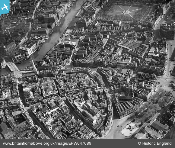
EPW047089 ENGLAND (1935). St Nicholas's Church, Colston Avenue and Baldwin Street, Bristol, 1935
© Copyright OpenStreetMap contributors and licensed by the OpenStreetMap Foundation. 2025. Cartography is licensed as CC BY-SA.
Nearby Images (10)
Details
| Title | [EPW047089] St Nicholas's Church, Colston Avenue and Baldwin Street, Bristol, 1935 |
| Reference | EPW047089 |
| Date | May-1935 |
| Link | |
| Place name | BRISTOL |
| Parish | |
| District | |
| Country | ENGLAND |
| Easting / Northing | 358797, 172905 |
| Longitude / Latitude | -2.5930455228303, 51.453137264773 |
| National Grid Reference | ST588729 |
Pins
 derek2847 |
Tuesday 6th of February 2018 10:16:02 PM | |
 derek2847 |
Tuesday 6th of February 2018 10:17:16 AM | |
 derek2847 |
Tuesday 6th of February 2018 10:15:40 AM | |
 derek2847 |
Tuesday 6th of February 2018 10:13:30 AM | |
 derek2847 |
Tuesday 6th of February 2018 10:07:07 AM | |
 MildBunch |
Wednesday 18th of February 2015 01:57:12 PM | |
 MildBunch |
Wednesday 18th of February 2015 01:56:59 PM | |
 MildBunch |
Wednesday 18th of February 2015 01:56:38 PM | |
 adfbristol |
Wednesday 26th of June 2013 01:41:35 PM | |
 adfbristol |
Wednesday 26th of June 2013 01:40:15 PM | |
 adfbristol |
Wednesday 26th of June 2013 01:39:32 PM | |
 Class31 |
Friday 21st of June 2013 08:00:28 AM |


![[EPW047089] St Nicholas's Church, Colston Avenue and Baldwin Street, Bristol, 1935](http://britainfromabove.org.uk/sites/all/libraries/aerofilms-images/public/100x100/EPW/047/EPW047089.jpg)
![[EPR000072] Baldwin Street, Bristol Bridge and the city centre, Bristol, 1934](http://britainfromabove.org.uk/sites/all/libraries/aerofilms-images/public/100x100/EPR/000/EPR000072.jpg)
![[EPW047090] Colston Avenue and the city centre, Bristol, 1935](http://britainfromabove.org.uk/sites/all/libraries/aerofilms-images/public/100x100/EPW/047/EPW047090.jpg)
![[EAW050555] Baldwin Street and environs, Bristol, 1953](http://britainfromabove.org.uk/sites/all/libraries/aerofilms-images/public/100x100/EAW/050/EAW050555.jpg)
![[EAW026794] The city centre, Bristol, from the south-west, 1949](http://britainfromabove.org.uk/sites/all/libraries/aerofilms-images/public/100x100/EAW/026/EAW026794.jpg)
![[EPR000085] Queen Square and the city centre, Bristol, 1934](http://britainfromabove.org.uk/sites/all/libraries/aerofilms-images/public/100x100/EPR/000/EPR000085.jpg)
![[EPW033498] Bristol Bridge and the city, Bristol, 1930](http://britainfromabove.org.uk/sites/all/libraries/aerofilms-images/public/100x100/EPW/033/EPW033498.jpg)
![[EPW005429] Quay Street and environs, Bristol, 1921](http://britainfromabove.org.uk/sites/all/libraries/aerofilms-images/public/100x100/EPW/005/EPW005429.jpg)
![[EPW005432] Quay Street and environs, Bristol, 1921](http://britainfromabove.org.uk/sites/all/libraries/aerofilms-images/public/100x100/EPW/005/EPW005432.jpg)
![[EPW012022] The Floating Harbour, Bristol, 1924. This image has been produced from a print.](http://britainfromabove.org.uk/sites/all/libraries/aerofilms-images/public/100x100/EPW/012/EPW012022.jpg)
