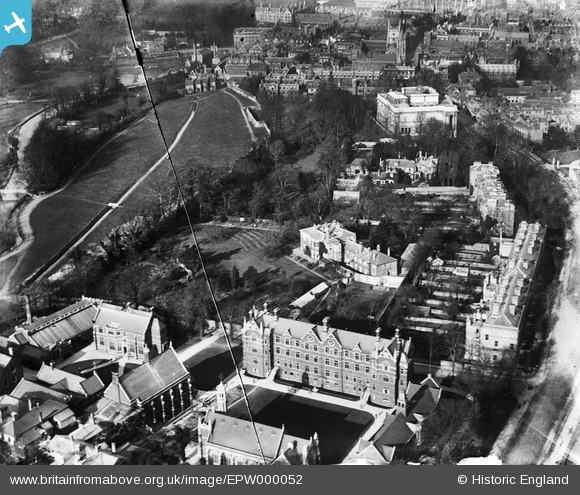
EPW000052 ENGLAND (1920). Scroope House and The Leys School, Cambridge, 1920
© Copyright OpenStreetMap contributors and licensed by the OpenStreetMap Foundation. 2025. Cartography is licensed as CC BY-SA.
Nearby Images (10)
Details
| Title | [EPW000052] Scroope House and The Leys School, Cambridge, 1920 |
| Reference | EPW000052 |
| Date | January-1920 |
| Link | |
| Place name | CAMBRIDGE |
| Parish | |
| District | |
| Country | ENGLAND |
| Easting / Northing | 544998, 257658 |
| Longitude / Latitude | 0.12179767848671, 52.197657563661 |
| National Grid Reference | TL450577 |
Pins
Be the first to add a comment to this image!


![[EPW000052] Scroope House and The Leys School, Cambridge, 1920](http://britainfromabove.org.uk/sites/all/libraries/aerofilms-images/public/100x100/EPW/000/EPW000052.jpg)
![[EPW025480] The city, Cambridge, from the south-west, 1928. This image has been produced from a copy-negative.](http://britainfromabove.org.uk/sites/all/libraries/aerofilms-images/public/100x100/EPW/025/EPW025480.jpg)
![[EPW059040] Trumpington Street, Addenbrooke's Hospital and environs, Cambridge, 1938. This image has been produced from a copy-negative.](http://britainfromabove.org.uk/sites/all/libraries/aerofilms-images/public/100x100/EPW/059/EPW059040.jpg)
![[EPW009775] The Fitzwilliam Museum, Cambridge, 1924](http://britainfromabove.org.uk/sites/all/libraries/aerofilms-images/public/100x100/EPW/009/EPW009775.jpg)
![[EPW000055] The Fitzwilliam Museum, Cambridge, 1920](http://britainfromabove.org.uk/sites/all/libraries/aerofilms-images/public/100x100/EPW/000/EPW000055.jpg)
![[EPW009788] The Fitzwilliam Museum, Cambridge, 1924](http://britainfromabove.org.uk/sites/all/libraries/aerofilms-images/public/100x100/EPW/009/EPW009788.jpg)
![[EAW011254] The city, Cambridge, from the south-east, 1947](http://britainfromabove.org.uk/sites/all/libraries/aerofilms-images/public/100x100/EAW/011/EAW011254.jpg)
![[EAW002920] Trumpington Street and the city centre, Cambridge, from the south-east, 1946](http://britainfromabove.org.uk/sites/all/libraries/aerofilms-images/public/100x100/EAW/002/EAW002920.jpg)
![[EAW002928] A rugby match being played on Leys School Sports Ground, Cambridge, 1946](http://britainfromabove.org.uk/sites/all/libraries/aerofilms-images/public/100x100/EAW/002/EAW002928.jpg)
![[EAW011253] Sheep's Green, the colleges and environs, Cambridge, from the south, 1947](http://britainfromabove.org.uk/sites/all/libraries/aerofilms-images/public/100x100/EAW/011/EAW011253.jpg)