
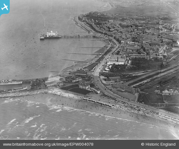
EPW004078 ENGLAND (1920). The Central Pier and town centre, Morecambe, 1920
© Copyright OpenStreetMap contributors and licensed by the OpenStreetMap Foundation. 2025. Cartography is licensed as CC BY-SA.
Nearby Images (12)
EPW004078

EPW042138

EAW026226

EAW023412

EPW042133

EPW004072

EPR000309

EPW042139

EPW042134

EPR000308

EPW004079

EAW026227

Details
| Title | [EPW004078] The Central Pier and town centre, Morecambe, 1920 |
| Reference | EPW004078 |
| Date | July-1920 |
| Link | |
| Place name | MORECAMBE |
| Parish | MORECAMBE |
| District | |
| Country | ENGLAND |
| Easting / Northing | 342976, 464425 |
| Longitude / Latitude | -2.871545071269, 54.072413441922 |
| National Grid Reference | SD430644 |
Pins
 Brigham |
Friday 6th of September 2024 04:55:38 PM | |
mikepeat |
Monday 26th of April 2021 10:50:59 PM | |
gBr |
Saturday 10th of January 2015 10:30:53 PM | |
SteveAUS |
Wednesday 8th of August 2012 05:07:07 AM | |
Euston Road |
Bob Fleetwood |
Saturday 29th of December 2012 09:40:51 AM |
SteveAUS |
Wednesday 8th of August 2012 05:04:15 AM | |
Bob Fleetwood |
Wednesday 18th of July 2012 10:59:14 PM | |
Bob Fleetwood |
Wednesday 18th of July 2012 10:56:18 PM | |
Bob Fleetwood |
Wednesday 18th of July 2012 10:54:23 PM | |
Bob Fleetwood |
Wednesday 18th of July 2012 10:53:36 PM | |
Bob Fleetwood |
Thursday 5th of July 2012 02:05:03 PM | |
Bob Fleetwood |
Thursday 5th of July 2012 02:01:15 PM | |
Bob Fleetwood |
Thursday 5th of July 2012 01:59:19 PM | |
Bob Fleetwood |
Thursday 5th of July 2012 01:58:37 PM | |
Bob Fleetwood |
Thursday 5th of July 2012 01:57:17 PM | |
Bob Fleetwood |
Thursday 5th of July 2012 01:56:09 PM | |
Bob Fleetwood |
Thursday 5th of July 2012 01:55:39 PM | |
Bob Fleetwood |
Thursday 5th of July 2012 01:55:00 PM | |
Bob Fleetwood |
Thursday 5th of July 2012 01:54:19 PM | |
Bob Fleetwood |
Thursday 5th of July 2012 01:53:51 PM | |
Bob Fleetwood |
Thursday 5th of July 2012 01:52:54 PM | |
SteveAUS |
Thursday 28th of June 2012 03:21:59 AM |
User Comment Contributions
To SteveAUS. I am inclined to agree with you but Euston Rd. Railway Station is not shown - or is to the right of the photo - could it be the building of the line? |
senojdet |
Saturday 10th of January 2015 10:33:18 PM |
I bet it is you know. If you see behind Thornton Road where Morecambe High is today. On the right of Morecambe High there is another big field. On the other side of this field is the railtway track with South road on the other side. |
SteveAUS |
Wednesday 8th of August 2012 04:59:55 AM |
Part of station is shown, notably the large toilet block at the western end of platform one. |
gBr |
Saturday 10th of January 2015 10:33:18 PM |
The Royalty Theatre, once known as The Opera House, was where Thora Herd's father used to work and where she first appeared on stage whilst she was still a child. |
Chris Richardson-Brand |
Thursday 12th of June 2014 11:51:44 AM |
The Warship being broken up is berthed against, what we knew as 'The Wooden Jetty. The partially dismantled ship is berthed alongside the stone Jetty - the subject of much recent work. Below the Clock Tower are the Ladies & Gentlemen s toilets. Above the C.T. is the Tower Ballroom and Cinema - renamed after the war as the 'Gaumont. To the right of the Tower is St. Mary's RC church. St. Laurenceces church is to the right, and slightly above the Winter Gardens. The smoke - or steam - on the right hand edge and slightly above the centre of the photo is where the Gas Works were situated. To the left of this and slightly above - the seven peak building is Euston Rd School and the large building to the left is the P{opulton rd. Art School. These are my recollections from the 1940's |
senojdet |
Wednesday 4th of July 2012 06:25:57 AM |
The Art School was Poulton Rd School. |
senojdet |
Sunday 1st of July 2012 11:26:09 AM |
Whats the white line in the top right hand corner. It looks like the same position that the railway line would be in that goes under York Bridge on Lancaster Road? |
SteveAUS |
Wednesday 4th of July 2012 06:25:57 AM |