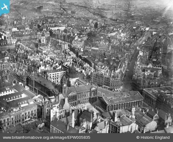
EPW005835 ENGLAND (1921). The Town Hall, New Street and environs, Birmingham, 1921. This image has been produced from a print.
© Copyright OpenStreetMap contributors and licensed by the OpenStreetMap Foundation. 2025. Cartography is licensed as CC BY-SA.
Nearby Images (40)
Details
| Title | [EPW005835] The Town Hall, New Street and environs, Birmingham, 1921. This image has been produced from a print. |
| Reference | EPW005835 |
| Date | March-1921 |
| Link | |
| Place name | BIRMINGHAM |
| Parish | |
| District | |
| Country | ENGLAND |
| Easting / Northing | 406778, 286908 |
| Longitude / Latitude | -1.900188212276, 52.479686082597 |
| National Grid Reference | SP068869 |
Pins
Be the first to add a comment to this image!


![[EPW005835] The Town Hall, New Street and environs, Birmingham, 1921. This image has been produced from a print.](http://britainfromabove.org.uk/sites/all/libraries/aerofilms-images/public/100x100/EPW/005/EPW005835.jpg)
![[EAW001234] New Street Railway Station and the city centre, Birmingham, 1946](http://britainfromabove.org.uk/sites/all/libraries/aerofilms-images/public/100x100/EAW/001/EAW001234.jpg)
![[EPW005853] Victoria Square, Colmore Row and environs, Birmingham, 1921. This image has been produced from a print.](http://britainfromabove.org.uk/sites/all/libraries/aerofilms-images/public/100x100/EPW/005/EPW005853.jpg)
![[EPW037053] Victoria Square and the city centre, Birmingham, 1931](http://britainfromabove.org.uk/sites/all/libraries/aerofilms-images/public/100x100/EPW/037/EPW037053.jpg)
![[EPW037056] Birmingham City Council House and the city centre, Birmingham, 1931](http://britainfromabove.org.uk/sites/all/libraries/aerofilms-images/public/100x100/EPW/037/EPW037056.jpg)
![[EPW005843] Colmore Row and Victoria Square area, Birmingham, 1921](http://britainfromabove.org.uk/sites/all/libraries/aerofilms-images/public/100x100/EPW/005/EPW005843.jpg)
![[EAW013566] The city centre including Victoria Square and Snow Hill Station, Birmingham, 1948](http://britainfromabove.org.uk/sites/all/libraries/aerofilms-images/public/100x100/EAW/013/EAW013566.jpg)
![[EPW005845] The Town Hall and Council House on Victoria Square, Birmingham, 1921](http://britainfromabove.org.uk/sites/all/libraries/aerofilms-images/public/100x100/EPW/005/EPW005845.jpg)
![[EPW005851] The Council House and Art Gallery, Birmingham, 1921. This image has been produced from a print.](http://britainfromabove.org.uk/sites/all/libraries/aerofilms-images/public/100x100/EPW/005/EPW005851.jpg)
![[EPW057480] Waterloo Street, Colmore Row and environs, Birmingham, 1938](http://britainfromabove.org.uk/sites/all/libraries/aerofilms-images/public/100x100/EPW/057/EPW057480.jpg)
![[EPW005836] The Town Hall and Council House on Victoria Square, Birmingham, 1921. This image has been produced from a print.](http://britainfromabove.org.uk/sites/all/libraries/aerofilms-images/public/100x100/EPW/005/EPW005836.jpg)
![[EAW001236] New Street and Snow Hill Railway Stations and the city centre, Birmingham, 1946](http://britainfromabove.org.uk/sites/all/libraries/aerofilms-images/public/100x100/EAW/001/EAW001236.jpg)
![[EPW005839] The Library, Town Hall and environs, Birmingham, 1921. This image has been produced from a print.](http://britainfromabove.org.uk/sites/all/libraries/aerofilms-images/public/100x100/EPW/005/EPW005839.jpg)
![[EPW005854] The Town Hall, Council House and Art Gallery, Birmingham, 1921. This image has been produced from a print.](http://britainfromabove.org.uk/sites/all/libraries/aerofilms-images/public/100x100/EPW/005/EPW005854.jpg)
![[EAW006930] New Street Railway Station and the city centre, Birmingham, 1947](http://britainfromabove.org.uk/sites/all/libraries/aerofilms-images/public/100x100/EAW/006/EAW006930.jpg)
![[EPW005849] St Philip's Cathedral and Colmore Row, Birmingham, 1921](http://britainfromabove.org.uk/sites/all/libraries/aerofilms-images/public/100x100/EPW/005/EPW005849.jpg)
![[EPW022584] The Town Hall and municipal buildings at Victoria Square, Birmingham, 1928](http://britainfromabove.org.uk/sites/all/libraries/aerofilms-images/public/100x100/EPW/022/EPW022584.jpg)
![[EAW001239] New Street Railway Station, St Philip's Cathedral and the city centre, Birmingham, 1946](http://britainfromabove.org.uk/sites/all/libraries/aerofilms-images/public/100x100/EAW/001/EAW001239.jpg)
![[EPW022588] The Town Hall and environs, Birmingham, 1928](http://britainfromabove.org.uk/sites/all/libraries/aerofilms-images/public/100x100/EPW/022/EPW022588.jpg)
![[EAW015327] New Street Railway Station, Smithfield Market and the city centre, Birmingham, 1948. This image has been produced from a print.](http://britainfromabove.org.uk/sites/all/libraries/aerofilms-images/public/100x100/EAW/015/EAW015327.jpg)
![[EPW005850] The Town Hall on Victoria Square and environs, Birmingham, 1921. This image has been produced from a print.](http://britainfromabove.org.uk/sites/all/libraries/aerofilms-images/public/100x100/EPW/005/EPW005850.jpg)
![[EPW053091] The area between Snow Hill Station and New Street including St Philip's Cathedral, Birmingham, 1937](http://britainfromabove.org.uk/sites/all/libraries/aerofilms-images/public/100x100/EPW/053/EPW053091.jpg)
![[EPW022585] The Hall of Memory, Birmingham, 1928](http://britainfromabove.org.uk/sites/all/libraries/aerofilms-images/public/100x100/EPW/022/EPW022585.jpg)
![[EAW035107] Corporation Street and environs, Birmingham, 1951](http://britainfromabove.org.uk/sites/all/libraries/aerofilms-images/public/100x100/EAW/035/EAW035107.jpg)
![[EAW001235] New Street and Snow Hill Railway Stations and the city centre, Birmingham, 1946](http://britainfromabove.org.uk/sites/all/libraries/aerofilms-images/public/100x100/EAW/001/EAW001235.jpg)
![[EAW026251] Snow Hill Station and the city centre, Birmingham, from the south-west, 1949](http://britainfromabove.org.uk/sites/all/libraries/aerofilms-images/public/100x100/EAW/026/EAW026251.jpg)
![[EAW013563] The city centre including the Hall of Memory, Baskerville House and Snow Hill Station, Birmingham, 1948](http://britainfromabove.org.uk/sites/all/libraries/aerofilms-images/public/100x100/EAW/013/EAW013563.jpg)
![[EAW029415] The Cathedral Church of St Philip and environs, Birmingham, 1950](http://britainfromabove.org.uk/sites/all/libraries/aerofilms-images/public/100x100/EAW/029/EAW029415.jpg)
![[EAW035108] New Street Station and environs, Birmingham, 1951](http://britainfromabove.org.uk/sites/all/libraries/aerofilms-images/public/100x100/EAW/035/EAW035108.jpg)
![[EAW013564] The city centre including the Hall of Memory, New Street Station and St Philip's Cathedral, Birmingham, from the south-west, 1948](http://britainfromabove.org.uk/sites/all/libraries/aerofilms-images/public/100x100/EAW/013/EAW013564.jpg)
![[EPW001136] Birmingham New Street Station and town centre, Birmingham, 1920](http://britainfromabove.org.uk/sites/all/libraries/aerofilms-images/public/100x100/EPW/001/EPW001136.jpg)
![[EAW026253] New Street Station and the city centre, Birmingham, from the south-east, 1949](http://britainfromabove.org.uk/sites/all/libraries/aerofilms-images/public/100x100/EAW/026/EAW026253.jpg)
![[EAW029414] The Cathedral Church of St Philip and environs, Birmingham, 1950](http://britainfromabove.org.uk/sites/all/libraries/aerofilms-images/public/100x100/EAW/029/EAW029414.jpg)
![[EPW005842] St Philip's Cathedral, Birmingham, 1921](http://britainfromabove.org.uk/sites/all/libraries/aerofilms-images/public/100x100/EPW/005/EPW005842.jpg)
![[EAW001237] New Street Railway Station, the Town Hall and the city centre, Birmingham, 1946](http://britainfromabove.org.uk/sites/all/libraries/aerofilms-images/public/100x100/EAW/001/EAW001237.jpg)
![[EPW005840] Birmingham New Street Station, Birmingham, 1921](http://britainfromabove.org.uk/sites/all/libraries/aerofilms-images/public/100x100/EPW/005/EPW005840.jpg)
![[EPW038601] New Street Station, Birmingham, 1932](http://britainfromabove.org.uk/sites/all/libraries/aerofilms-images/public/100x100/EPW/038/EPW038601.jpg)
![[EPW022586] New Street Railway Station, Birmingham, 1928](http://britainfromabove.org.uk/sites/all/libraries/aerofilms-images/public/100x100/EPW/022/EPW022586.jpg)
![[EPW058129] New Street Station, Birmingham, 1938](http://britainfromabove.org.uk/sites/all/libraries/aerofilms-images/public/100x100/EPW/058/EPW058129.jpg)
![[EPW054234] The city centre, Birmingham, from the south-east, 1937](http://britainfromabove.org.uk/sites/all/libraries/aerofilms-images/public/100x100/EPW/054/EPW054234.jpg)