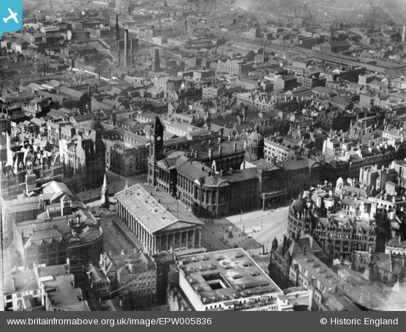
EPW005836 ENGLAND (1921). The Town Hall and Council House on Victoria Square, Birmingham, 1921. This image has been produced from a print.
© Copyright OpenStreetMap contributors and licensed by the OpenStreetMap Foundation. 2025. Cartography is licensed as CC BY-SA.
Nearby Images (29)
Details
| Title | [EPW005836] The Town Hall and Council House on Victoria Square, Birmingham, 1921. This image has been produced from a print. |
| Reference | EPW005836 |
| Date | March-1921 |
| Link | |
| Place name | BIRMINGHAM |
| Parish | |
| District | |
| Country | ENGLAND |
| Easting / Northing | 406650, 286936 |
| Longitude / Latitude | -1.9020725586654, 52.479939405542 |
| National Grid Reference | SP067869 |
Pins
Be the first to add a comment to this image!


![[EPW005836] The Town Hall and Council House on Victoria Square, Birmingham, 1921. This image has been produced from a print.](http://britainfromabove.org.uk/sites/all/libraries/aerofilms-images/public/100x100/EPW/005/EPW005836.jpg)
![[EPW005839] The Library, Town Hall and environs, Birmingham, 1921. This image has been produced from a print.](http://britainfromabove.org.uk/sites/all/libraries/aerofilms-images/public/100x100/EPW/005/EPW005839.jpg)
![[EPW005854] The Town Hall, Council House and Art Gallery, Birmingham, 1921. This image has been produced from a print.](http://britainfromabove.org.uk/sites/all/libraries/aerofilms-images/public/100x100/EPW/005/EPW005854.jpg)
![[EAW013566] The city centre including Victoria Square and Snow Hill Station, Birmingham, 1948](http://britainfromabove.org.uk/sites/all/libraries/aerofilms-images/public/100x100/EAW/013/EAW013566.jpg)
![[EPW005851] The Council House and Art Gallery, Birmingham, 1921. This image has been produced from a print.](http://britainfromabove.org.uk/sites/all/libraries/aerofilms-images/public/100x100/EPW/005/EPW005851.jpg)
![[EPW022584] The Town Hall and municipal buildings at Victoria Square, Birmingham, 1928](http://britainfromabove.org.uk/sites/all/libraries/aerofilms-images/public/100x100/EPW/022/EPW022584.jpg)
![[EPW005845] The Town Hall and Council House on Victoria Square, Birmingham, 1921](http://britainfromabove.org.uk/sites/all/libraries/aerofilms-images/public/100x100/EPW/005/EPW005845.jpg)
![[EPW037056] Birmingham City Council House and the city centre, Birmingham, 1931](http://britainfromabove.org.uk/sites/all/libraries/aerofilms-images/public/100x100/EPW/037/EPW037056.jpg)
![[EPW022585] The Hall of Memory, Birmingham, 1928](http://britainfromabove.org.uk/sites/all/libraries/aerofilms-images/public/100x100/EPW/022/EPW022585.jpg)
![[EPW005850] The Town Hall on Victoria Square and environs, Birmingham, 1921. This image has been produced from a print.](http://britainfromabove.org.uk/sites/all/libraries/aerofilms-images/public/100x100/EPW/005/EPW005850.jpg)
![[EAW026251] Snow Hill Station and the city centre, Birmingham, from the south-west, 1949](http://britainfromabove.org.uk/sites/all/libraries/aerofilms-images/public/100x100/EAW/026/EAW026251.jpg)
![[EPW037053] Victoria Square and the city centre, Birmingham, 1931](http://britainfromabove.org.uk/sites/all/libraries/aerofilms-images/public/100x100/EPW/037/EPW037053.jpg)
![[EPW005835] The Town Hall, New Street and environs, Birmingham, 1921. This image has been produced from a print.](http://britainfromabove.org.uk/sites/all/libraries/aerofilms-images/public/100x100/EPW/005/EPW005835.jpg)
![[EAW013563] The city centre including the Hall of Memory, Baskerville House and Snow Hill Station, Birmingham, 1948](http://britainfromabove.org.uk/sites/all/libraries/aerofilms-images/public/100x100/EAW/013/EAW013563.jpg)
![[EPW005853] Victoria Square, Colmore Row and environs, Birmingham, 1921. This image has been produced from a print.](http://britainfromabove.org.uk/sites/all/libraries/aerofilms-images/public/100x100/EPW/005/EPW005853.jpg)
![[EAW013564] The city centre including the Hall of Memory, New Street Station and St Philip's Cathedral, Birmingham, from the south-west, 1948](http://britainfromabove.org.uk/sites/all/libraries/aerofilms-images/public/100x100/EAW/013/EAW013564.jpg)
![[EPW022588] The Town Hall and environs, Birmingham, 1928](http://britainfromabove.org.uk/sites/all/libraries/aerofilms-images/public/100x100/EPW/022/EPW022588.jpg)
![[EAW006930] New Street Railway Station and the city centre, Birmingham, 1947](http://britainfromabove.org.uk/sites/all/libraries/aerofilms-images/public/100x100/EAW/006/EAW006930.jpg)
![[EAW001234] New Street Railway Station and the city centre, Birmingham, 1946](http://britainfromabove.org.uk/sites/all/libraries/aerofilms-images/public/100x100/EAW/001/EAW001234.jpg)
![[EPW005843] Colmore Row and Victoria Square area, Birmingham, 1921](http://britainfromabove.org.uk/sites/all/libraries/aerofilms-images/public/100x100/EPW/005/EPW005843.jpg)
![[EPW057483] The Hall of Memory, Baskerville House under construction and the city, Birmingham, from the south, 1938](http://britainfromabove.org.uk/sites/all/libraries/aerofilms-images/public/100x100/EPW/057/EPW057483.jpg)
![[EAW026250] The Hall of Memory, Town Hall and city centre, Birmingham, from the south-west, 1949](http://britainfromabove.org.uk/sites/all/libraries/aerofilms-images/public/100x100/EAW/026/EAW026250.jpg)
![[EPW057480] Waterloo Street, Colmore Row and environs, Birmingham, 1938](http://britainfromabove.org.uk/sites/all/libraries/aerofilms-images/public/100x100/EPW/057/EPW057480.jpg)
![[EAW001236] New Street and Snow Hill Railway Stations and the city centre, Birmingham, 1946](http://britainfromabove.org.uk/sites/all/libraries/aerofilms-images/public/100x100/EAW/001/EAW001236.jpg)
![[EPW053101] Great Charles Street, Lionel Street and environs, Birmingham, 1937](http://britainfromabove.org.uk/sites/all/libraries/aerofilms-images/public/100x100/EPW/053/EPW053101.jpg)
![[EPW005849] St Philip's Cathedral and Colmore Row, Birmingham, 1921](http://britainfromabove.org.uk/sites/all/libraries/aerofilms-images/public/100x100/EPW/005/EPW005849.jpg)
![[EAW013565] The city centre including the Hall of Memory, Baskerville House and the West End Cinema, Birmingham, 1948](http://britainfromabove.org.uk/sites/all/libraries/aerofilms-images/public/100x100/EAW/013/EAW013565.jpg)
![[EPW038600] The Hall of Memory, New Street Station and environs, Birmingham, 1932](http://britainfromabove.org.uk/sites/all/libraries/aerofilms-images/public/100x100/EPW/038/EPW038600.jpg)
![[EPW038606] Snow Hill Station, Newhall Street and environs, Birmingham, 1932](http://britainfromabove.org.uk/sites/all/libraries/aerofilms-images/public/100x100/EPW/038/EPW038606.jpg)