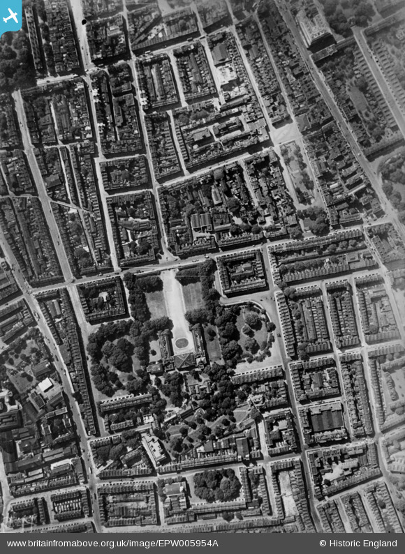
EPW005954A ENGLAND (1921). Coram's Fields, Great Ormond Street and environs, Bloomsbury, 1921. This image has been produced from a copy-negative.
© Copyright OpenStreetMap contributors and licensed by the OpenStreetMap Foundation. 2024. Cartography is licensed as CC BY-SA.
Nearby Images (8)
Details
| Title | [EPW005954A] Coram's Fields, Great Ormond Street and environs, Bloomsbury, 1921. This image has been produced from a copy-negative. |
| Reference | EPW005954A |
| Date | 26-April-1921 |
| Link | |
| Place name | BLOOMSBURY |
| Parish | |
| District | |
| Country | ENGLAND |
| Easting / Northing | 530489, 182183 |
| Longitude / Latitude | -0.11889723326211, 51.522987339665 |
| National Grid Reference | TQ305822 |
Pins
 ade |
Friday 17th of July 2020 08:51:55 AM | |
 Polly Shields |
Friday 17th of April 2020 11:58:28 PM | |
 billyfern |
Tuesday 4th of November 2014 05:54:03 PM | |
 billyfern |
Tuesday 4th of November 2014 05:53:05 PM | |
 billyfern |
Tuesday 4th of November 2014 05:52:23 PM | |
 billyfern |
Tuesday 4th of November 2014 05:51:39 PM | |
 billyfern |
Tuesday 4th of November 2014 05:50:54 PM | |
 billyfern |
Tuesday 4th of November 2014 05:50:22 PM | |
 billyfern |
Tuesday 4th of November 2014 05:49:59 PM | |
 billyfern |
Tuesday 4th of November 2014 05:49:13 PM | |
 billyfern |
Tuesday 4th of November 2014 05:48:46 PM | |
 billyfern |
Tuesday 4th of November 2014 05:48:19 PM |


![[EPW005954A] Coram's Fields, Great Ormond Street and environs, Bloomsbury, 1921. This image has been produced from a copy-negative.](http://britainfromabove.org.uk/sites/all/libraries/aerofilms-images/public/100x100/EPW/005/EPW005954A.jpg)
![[EPW035200] The Foundling Hospital site (Coram's Fields) and environs, Bloomsbury, 1931. This image has been produced from a damaged negative.](http://britainfromabove.org.uk/sites/all/libraries/aerofilms-images/public/100x100/EPW/035/EPW035200.jpg)
![[EPW035202] The Foundling Hospital site (Coram's Fields) and environs, Bloomsbury, 1931](http://britainfromabove.org.uk/sites/all/libraries/aerofilms-images/public/100x100/EPW/035/EPW035202.jpg)
![[EPW035203] The Foundling Hospital site (Coram's Fields) and environs, Bloomsbury, 1931](http://britainfromabove.org.uk/sites/all/libraries/aerofilms-images/public/100x100/EPW/035/EPW035203.jpg)
![[EPW035201] The Foundling Hospital site (Coram's Fields) and environs, Bloomsbury, 1931. This image has been produced from a damaged negative.](http://britainfromabove.org.uk/sites/all/libraries/aerofilms-images/public/100x100/EPW/035/EPW035201.jpg)
![[EAW011087] Great Ormond Street and environs, Holborn, 1947](http://britainfromabove.org.uk/sites/all/libraries/aerofilms-images/public/100x100/EAW/011/EAW011087.jpg)
![[EAW011086] Hotel Russell and Bernard Street, Bloomsbury, 1947](http://britainfromabove.org.uk/sites/all/libraries/aerofilms-images/public/100x100/EAW/011/EAW011086.jpg)
![[EAW011209] Gray's Inn Road and St Andrew's Gardens, St Pancras, 1947](http://britainfromabove.org.uk/sites/all/libraries/aerofilms-images/public/100x100/EAW/011/EAW011209.jpg)