
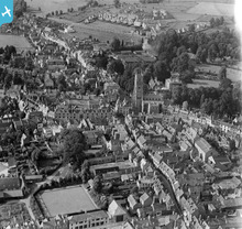
EPW006310 ENGLAND (1921). The town centre, Cirencester, 1921

© Copyright OpenStreetMap contributors and licensed by the OpenStreetMap Foundation. 2025. Cartography is licensed as CC BY-SA.
Nearby Images (19)
EPW006310

EPW022410

EPW022416

EPW022412

EAW031681

EPW022407

EPW022413

EAW006877

EAW031677

EPW022417

EPW061776

EPW061780

EPW022415

EPW061775

EAW031680

EAW006878

EAW015788

EAW015789

EPW022409

Details
| Title | [EPW006310] The town centre, Cirencester, 1921 |
| Reference | EPW006310 |
| Date | 23-May-1921 |
| Link | |
| Place name | CIRENCESTER |
| Parish | CIRENCESTER |
| District | |
| Country | ENGLAND |
| Easting / Northing | 402281, 202019 |
| Longitude / Latitude | -1.9669787941242, 51.716436395303 |
| National Grid Reference | SP023020 |
Pins
 Alan McFaden |
Wednesday 21st of May 2014 09:47:27 PM | |
 SydM |
Saturday 8th of March 2014 05:54:44 PM | |
In 1921 this building was the Cotswold Garage and was built after World war 1 from aircraft hangers originally built at Rendcomb Airfield for the Royal Flying Corp.Three hangers were dismantled and rebuilt in the town,one as The Cotswold garage,two as Bridges Garage that was adjacent to the Cotswold,and a third more as half the original size as Harmans Builders at the West end of Ashcroft Road and Sheep Street.It was in 1940 that Mycalex moved out of London due to the Blitz and took over the property until 1973. |
cherrytree |
Tuesday 30th of December 2014 04:39:18 PM |
 Class31 |
Thursday 24th of January 2013 07:39:30 PM | |
Class31 |
Thursday 24th of January 2013 07:38:44 PM | |
Class31 |
Thursday 24th of January 2013 07:37:06 PM | |
Class31 |
Thursday 24th of January 2013 07:35:05 PM | |
Class31 |
Thursday 24th of January 2013 07:34:18 PM | |
Class31 |
Thursday 24th of January 2013 07:31:16 PM | |
Class31 |
Sunday 28th of October 2012 11:07:23 PM | |
Rob C |
Friday 12th of October 2012 01:35:56 PM | |
Tetbury |
Sunday 1st of July 2012 12:49:44 AM | |
Tetbury |
Sunday 1st of July 2012 12:48:39 AM | |
Tetbury |
Sunday 1st of July 2012 12:47:45 AM | |
Tetbury |
Sunday 1st of July 2012 12:47:08 AM | |
Tetbury |
Sunday 1st of July 2012 12:46:30 AM | |
Tetbury |
Sunday 1st of July 2012 12:45:44 AM | |
Tetbury |
Wednesday 27th of June 2012 07:11:26 PM | |
Tetbury |
Wednesday 27th of June 2012 01:51:38 AM |
User Comment Contributions
I have sincere doubts that the year 1921 is correct.The photograph shows the Bowling Green as a fully completed playing area but the club was not opened until 1930 and a further photo dated 1928 shows the position as a field that horses from the nearby Brewery used as grazing. |
cherrytree |
Tuesday 30th of December 2014 04:52:27 PM |
 The town centre, Cirencester |
Lynda Tubbs |
Saturday 4th of October 2014 08:01:51 AM |
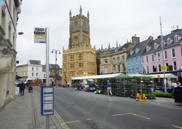
 This photo (EPW006310) a view north from the south end of Cricklade Street. See also a recent taken by R Bewley April 22 2012. Bob Bewley |
Bob Bewley |
Monday 30th of July 2012 06:18:01 PM |
Cirencester town centre from the SE. Cricklade Street at the bottom right. To the top left, the old Gloucester road, following the line of a Roman road, and to the top right, there are the houses around Bowling Green Lane and on The Whiteway, also a Roman road. |
C R Munro |
Wednesday 27th of June 2012 08:29:46 PM |
The photograph dates after 1937 as it clearly depicts the new Cirencester Brewery office buildings located on Cricklade Street. This building replaced the former engine house and three large chimney stacks made redundant in 1937 when brewing ceased on this site. These can clearly be noted in photo number EPW022416 dated 1928. |
Tetbury |
Wednesday 27th of June 2012 07:11:57 PM |
Cirencester Bowls club in forefront and Ashcroft Road |
D0111E |
Tuesday 26th of June 2012 03:04:43 PM |
Cirencester town centre. Street in the foreground is Cricklade Street. |
 Laura Maddison |
Friday 22nd of June 2012 01:28:25 PM |
Cirencester - St John's Parish Church, from the South |
egide |
Friday 25th of May 2012 06:03:34 PM |