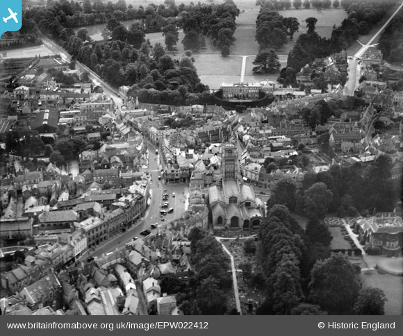
EPW022412 ENGLAND (1928). St John the Baptist's Church and Cirencester Park, Cirencester, 1928
© Copyright OpenStreetMap contributors and licensed by the OpenStreetMap Foundation. 2025. Cartography is licensed as CC BY-SA.
Nearby Images (19)
Details
| Title | [EPW022412] St John the Baptist's Church and Cirencester Park, Cirencester, 1928 |
| Reference | EPW022412 |
| Date | August-1928 |
| Link | |
| Place name | CIRENCESTER |
| Parish | CIRENCESTER |
| District | |
| Country | ENGLAND |
| Easting / Northing | 402252, 202056 |
| Longitude / Latitude | -1.9673983772453, 51.71676922293 |
| National Grid Reference | SP023021 |
Pins
 Alan McFaden |
Wednesday 21st of May 2014 10:05:14 PM | |
 Alan McFaden |
Wednesday 21st of May 2014 09:39:40 PM | |
 Alan McFaden |
Wednesday 21st of May 2014 09:39:03 PM | |
 SydM |
Saturday 8th of March 2014 05:53:50 PM | |
 Class31 |
Monday 10th of June 2013 09:31:53 PM | |
 Class31 |
Thursday 24th of January 2013 08:30:37 PM | |
 Class31 |
Thursday 24th of January 2013 08:27:24 PM | |
 Class31 |
Thursday 24th of January 2013 08:25:34 PM | |
 Class31 |
Thursday 24th of January 2013 08:24:34 PM | |
 Class31 |
Thursday 24th of January 2013 08:23:52 PM | |
 Class31 |
Thursday 24th of January 2013 08:23:17 PM | |
 Class31 |
Thursday 24th of January 2013 08:22:43 PM | |
 Tetbury |
Wednesday 27th of June 2012 08:43:05 PM | |
 Tetbury |
Wednesday 27th of June 2012 08:42:08 PM | |
 Tetbury |
Wednesday 27th of June 2012 08:32:46 PM | |
 Tetbury |
Wednesday 27th of June 2012 08:15:05 PM | |
 Tetbury |
Wednesday 27th of June 2012 08:10:26 PM |
User Comment Contributions
Lynda Tubbs |
Tuesday 8th of July 2014 03:35:48 PM |


![[EPW022412] St John the Baptist's Church and Cirencester Park, Cirencester, 1928](http://britainfromabove.org.uk/sites/all/libraries/aerofilms-images/public/100x100/EPW/022/EPW022412.jpg)
![[EPW022416] St John the Baptist's Church and Market Place, Cirencester, 1928](http://britainfromabove.org.uk/sites/all/libraries/aerofilms-images/public/100x100/EPW/022/EPW022416.jpg)
![[EPW022410] The Town Centre, Cirencester, from the north-west, 1928](http://britainfromabove.org.uk/sites/all/libraries/aerofilms-images/public/100x100/EPW/022/EPW022410.jpg)
![[EPW006310] The town centre, Cirencester, 1921](http://britainfromabove.org.uk/sites/all/libraries/aerofilms-images/public/100x100/EPW/006/EPW006310.jpg)
![[EAW031681] St John the Baptist's Church and the town centre, Cirencester, 1950](http://britainfromabove.org.uk/sites/all/libraries/aerofilms-images/public/100x100/EAW/031/EAW031681.jpg)
![[EAW031677] The town centre, Cirencester, 1950](http://britainfromabove.org.uk/sites/all/libraries/aerofilms-images/public/100x100/EAW/031/EAW031677.jpg)
![[EPW022407] The Town Centre and the Fosse Way, Cirencester, from the north-east, 1928](http://britainfromabove.org.uk/sites/all/libraries/aerofilms-images/public/100x100/EPW/022/EPW022407.jpg)
![[EAW006877] The town centre, Cirencester, 1947](http://britainfromabove.org.uk/sites/all/libraries/aerofilms-images/public/100x100/EAW/006/EAW006877.jpg)
![[EPW022413] St John the Baptist's Church and the Corn Hall, Cirencester, 1928](http://britainfromabove.org.uk/sites/all/libraries/aerofilms-images/public/100x100/EPW/022/EPW022413.jpg)
![[EAW031680] Cirencester Park, St John the Baptist's Church and the town centre, Cirencester, 1950](http://britainfromabove.org.uk/sites/all/libraries/aerofilms-images/public/100x100/EAW/031/EAW031680.jpg)
![[EPW061776] St John the Baptist's Church and Abbey House, Cirencester, 1939](http://britainfromabove.org.uk/sites/all/libraries/aerofilms-images/public/100x100/EPW/061/EPW061776.jpg)
![[EPW061775] Abbey House, Cirencester, 1939](http://britainfromabove.org.uk/sites/all/libraries/aerofilms-images/public/100x100/EPW/061/EPW061775.jpg)
![[EPW022417] The Town Centre, Cirencester, 1928](http://britainfromabove.org.uk/sites/all/libraries/aerofilms-images/public/100x100/EPW/022/EPW022417.jpg)
![[EPW061780] St John the Baptist's Church and Abbey House, Cirencester, 1939](http://britainfromabove.org.uk/sites/all/libraries/aerofilms-images/public/100x100/EPW/061/EPW061780.jpg)
![[EAW015789] Cirencester Park, Cirencester, 1948. This image has been produced from a print.](http://britainfromabove.org.uk/sites/all/libraries/aerofilms-images/public/100x100/EAW/015/EAW015789.jpg)
![[EAW015788] The 188th US Army General Hospital in Cirencester Park, Cirencester, from the east, 1948. This image has been produced from a print marked by Aerofilms Ltd for photo editing.](http://britainfromabove.org.uk/sites/all/libraries/aerofilms-images/public/100x100/EAW/015/EAW015788.jpg)
![[EPW022415] The Town Centre and Broad Ride, Cirencester, from the north-east, 1928](http://britainfromabove.org.uk/sites/all/libraries/aerofilms-images/public/100x100/EPW/022/EPW022415.jpg)
![[EAW006878] The town, Cirencester, 1947](http://britainfromabove.org.uk/sites/all/libraries/aerofilms-images/public/100x100/EAW/006/EAW006878.jpg)
![[EPW022408] The Town Centre, Cirencester, 1928](http://britainfromabove.org.uk/sites/all/libraries/aerofilms-images/public/100x100/EPW/022/EPW022408.jpg)


