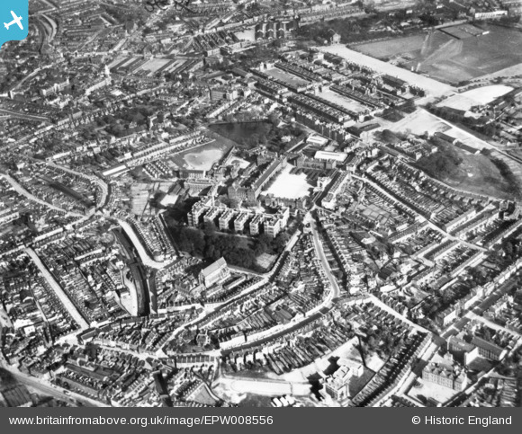
EPW008556 ENGLAND (1923). The Red and Cambridge Barracks and environs, Woolwich, 1923. This image has been produced from a print.
© Copyright OpenStreetMap contributors and licensed by the OpenStreetMap Foundation. 2024. Cartography is licensed as CC BY-SA.
Details
| Title | [EPW008556] The Red and Cambridge Barracks and environs, Woolwich, 1923. This image has been produced from a print. |
| Reference | EPW008556 |
| Date | 1923 |
| Link | |
| Place name | WOOLWICH |
| Parish | |
| District | |
| Country | ENGLAND |
| Easting / Northing | 542782, 178716 |
| Longitude / Latitude | 0.056794666460793, 51.488856107077 |
| National Grid Reference | TQ428787 |
Pins
 John W |
Tuesday 3rd of May 2016 09:48:47 PM | |
 John W |
Tuesday 3rd of May 2016 09:47:51 PM | |
 John W |
Tuesday 3rd of May 2016 09:46:51 PM | |
 John W |
Tuesday 3rd of May 2016 09:45:05 PM | |
 John W |
Tuesday 3rd of May 2016 09:43:59 PM | |
 John W |
Tuesday 3rd of May 2016 09:43:20 PM | |
 John W |
Tuesday 3rd of May 2016 09:42:43 PM | |
 John W |
Tuesday 3rd of May 2016 09:41:44 PM | |
 John W |
Tuesday 3rd of May 2016 09:40:52 PM | |
 TurnWat4 |
Wednesday 1st of July 2015 06:12:41 PM | |
 TurnWat4 |
Wednesday 1st of July 2015 06:12:36 PM | |
 The Laird |
Thursday 28th of May 2015 04:48:09 PM | |
 The Laird |
Thursday 28th of May 2015 04:47:43 PM | |
 The Laird |
Thursday 28th of May 2015 04:45:04 PM |


![[EPW008556] The Red and Cambridge Barracks and environs, Woolwich, 1923. This image has been produced from a print.](http://britainfromabove.org.uk/sites/all/libraries/aerofilms-images/public/100x100/EPW/008/EPW008556.jpg)
![[EPW010750] Cambridge and Red Barracks and the River Thames, Woolwich, from the south, 1924. This image has been produced from a copy-negative.](http://britainfromabove.org.uk/sites/all/libraries/aerofilms-images/public/100x100/EPW/010/EPW010750.jpg)
![[EPW010747] Cambridge and Red Barracks and the surrounding area, Woolwich, 1924. This image has been produced from a print.](http://britainfromabove.org.uk/sites/all/libraries/aerofilms-images/public/100x100/EPW/010/EPW010747.jpg)