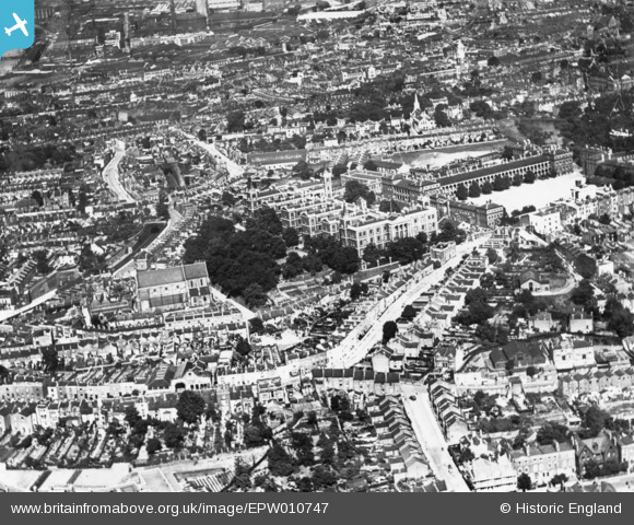
EPW010747 ENGLAND (1924). Cambridge and Red Barracks and the surrounding area, Woolwich, 1924. This image has been produced from a print.
© Copyright OpenStreetMap contributors and licensed by the OpenStreetMap Foundation. 2024. Cartography is licensed as CC BY-SA.
Details
| Title | [EPW010747] Cambridge and Red Barracks and the surrounding area, Woolwich, 1924. This image has been produced from a print. |
| Reference | EPW010747 |
| Date | June-1924 |
| Link | |
| Place name | WOOLWICH |
| Parish | |
| District | |
| Country | ENGLAND |
| Easting / Northing | 542718, 178765 |
| Longitude / Latitude | 0.055893189208059, 51.489312615917 |
| National Grid Reference | TQ427788 |
Pins
 Biff |
Friday 23rd of July 2021 07:12:30 PM | |
 John W |
Tuesday 9th of August 2016 09:51:46 PM | |
 John W |
Tuesday 9th of August 2016 09:50:22 PM | |
 John W |
Tuesday 3rd of May 2016 10:02:14 PM | |
Are you Johnny Webb? |
 johno |
Sunday 18th of September 2016 08:50:09 PM |
 John W |
Tuesday 3rd of May 2016 10:01:04 PM | |
 John W |
Tuesday 3rd of May 2016 10:00:06 PM | |
 John W |
Tuesday 3rd of May 2016 09:59:32 PM | |
 John W |
Tuesday 3rd of May 2016 09:59:04 PM |


![[EPW010747] Cambridge and Red Barracks and the surrounding area, Woolwich, 1924. This image has been produced from a print.](http://britainfromabove.org.uk/sites/all/libraries/aerofilms-images/public/100x100/EPW/010/EPW010747.jpg)
![[EPW008556] The Red and Cambridge Barracks and environs, Woolwich, 1923. This image has been produced from a print.](http://britainfromabove.org.uk/sites/all/libraries/aerofilms-images/public/100x100/EPW/008/EPW008556.jpg)
![[EPW010750] Cambridge and Red Barracks and the River Thames, Woolwich, from the south, 1924. This image has been produced from a copy-negative.](http://britainfromabove.org.uk/sites/all/libraries/aerofilms-images/public/100x100/EPW/010/EPW010750.jpg)