
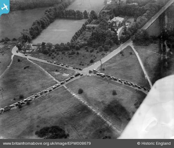
EPW008679 ENGLAND (1923). Fir Tree Road, Banstead, 1923
© Copyright OpenStreetMap contributors and licensed by the OpenStreetMap Foundation. 2025. Cartography is licensed as CC BY-SA.
Nearby Images (3)
EPW008679

EPW008678

EPW007910

Details
| Title | [EPW008679] Fir Tree Road, Banstead, 1923 |
| Reference | EPW008679 |
| Date | 1923 |
| Link | |
| Place name | BANSTEAD |
| Parish | |
| District | |
| Country | ENGLAND |
| Easting / Northing | 524802, 160267 |
| Longitude / Latitude | -0.20855686745099, 51.327287480434 |
| National Grid Reference | TQ248603 |
Pins
 Banstead100 |
Friday 31st of August 2018 06:43:50 PM | |
Peter Denton |
Sunday 16th of November 2014 02:22:37 PM | |
Peter Denton |
Sunday 16th of November 2014 02:20:02 PM | |
Rob |
Tuesday 21st of October 2014 09:08:15 PM | |
Rob |
Tuesday 5th of November 2013 05:24:00 PM | |
Rob |
Tuesday 5th of November 2013 05:23:26 PM | |
Rob |
Tuesday 5th of November 2013 05:22:35 PM | |
Rob |
Tuesday 5th of November 2013 05:21:39 PM |
User Comment Contributions
No, Banstead Hall is off the photo, as it fronted the present A217 but was south of Basing House (the one with the chimneys sticking through the trees at the very top of this picture - the picture looks more or less south east). In its final form, it was quite a lot bigger than either Basing House or Banstead House shown in this image. The Banstead Hall facades were in brick, a re-casing of the original building constructed c.1860-65. The architect for the 1880 re-casing modification was Ernest Newton and the work was for the Maitland family who turned it into a private school. A few of Newton's drawings of Banstead Hall have survived and are in the RIBA library. |
Luciole |
Monday 6th of October 2014 02:45:06 PM |
Think the big house in this photo was Banstead Hall, built circa 1880. |
Tina |
Saturday 8th of March 2014 10:53:21 PM |
If you enlarge the picture sufficiently, at the top of the photo behind the easily visible large house (Banstead House) are the chimneys and rooftops of another mansion. This is Basing House, demolished in about 1952. In its very last years, it was used by the Banstead Hall Approved School for training 16-18 year old boys for the building industry. After its demolition a modern single story building was constructed on its site for use as a all weather building trades training centre. |
Luciole |
Friday 15th of November 2013 06:00:32 PM |
The picture looks towards the south east. The large house is Banstead House. It was commandeered during WW2 and the internal fittings were much damaged during the 1945 VE day celebrations. The house was repaired although not restored to be incorporated into the Banstead Hall estate. It used from the late 40s as a dormitory building and common room for boys of the Banstead Hall Approved School. The house on the left hand side of the photo was designed by Ernest Newton, one time President of the RIBA, also designer of the nearby and now demolished Banstead Hall. It was known as Bolter's Corner and was used for staff accommodation for the Banstead Hall Approved School from the late forties to the seventies. The small white building in the centre of picture at the very top was built before WW1 as the Cricket Pavilion for the private school run by the Maitland family in Banstead Hall. It was demolished when Banstead Hall was demolished. |
Luciole |
Friday 15th of November 2013 05:50:12 PM |
Looking at the amount of traffic going down Firtree Road I suggest they possibly heading for Epsom Races - 1923 Derby ? |
Rob |
Tuesday 5th of November 2013 05:26:29 PM |