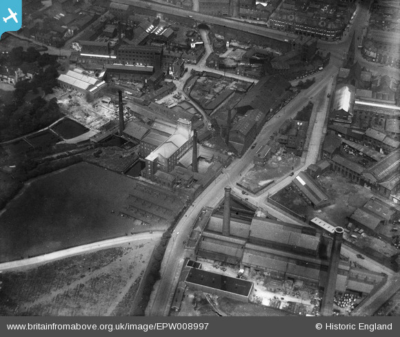
EPW008997 ENGLAND (1923). The Borough Corn Mill and environs, Bolton, 1923
© Copyright OpenStreetMap contributors and licensed by the OpenStreetMap Foundation. 2025. Cartography is licensed as CC BY-SA.
Nearby Images (17)
Details
| Title | [EPW008997] The Borough Corn Mill and environs, Bolton, 1923 |
| Reference | EPW008997 |
| Date | 13-July-1923 |
| Link | |
| Place name | BOLTON |
| Parish | |
| District | |
| Country | ENGLAND |
| Easting / Northing | 371105, 409198 |
| Longitude / Latitude | -2.436456639457, 53.57834043128 |
| National Grid Reference | SD711092 |
Pins
 tam |
Monday 14th of July 2014 02:45:25 PM | |
 dave44 |
Sunday 29th of June 2014 08:38:53 PM | |
 dave44 |
Sunday 29th of June 2014 08:05:24 PM | |
 dave44 |
Saturday 28th of June 2014 04:31:02 PM | |
 dave44 |
Saturday 28th of June 2014 04:11:52 PM | |
 dave44 |
Saturday 28th of June 2014 04:08:22 PM | |
 dave44 |
Saturday 28th of June 2014 04:07:38 PM | |
 dave44 |
Saturday 28th of June 2014 04:05:20 PM | |
 dave44 |
Saturday 28th of June 2014 04:02:46 PM | |
 dave44 |
Saturday 28th of June 2014 04:01:15 PM | |
 dave44 |
Tuesday 25th of March 2014 05:01:15 PM | |
 dave44 |
Tuesday 25th of March 2014 04:58:15 PM |


![[EPW008997] The Borough Corn Mill and environs, Bolton, 1923](http://britainfromabove.org.uk/sites/all/libraries/aerofilms-images/public/100x100/EPW/008/EPW008997.jpg)
![[EPW008998] The Borough Corn Mill and environs, Bolton, 1923](http://britainfromabove.org.uk/sites/all/libraries/aerofilms-images/public/100x100/EPW/008/EPW008998.jpg)
![[EPW008995] The Borough Corn Mill and environs, Bolton, 1923](http://britainfromabove.org.uk/sites/all/libraries/aerofilms-images/public/100x100/EPW/008/EPW008995.jpg)
![[EPW008992] The Borough Corn Mill and environs, Bolton, 1923](http://britainfromabove.org.uk/sites/all/libraries/aerofilms-images/public/100x100/EPW/008/EPW008992.jpg)
![[EPW008993] The Borough Corn Mill and environs, Bolton, 1923](http://britainfromabove.org.uk/sites/all/libraries/aerofilms-images/public/100x100/EPW/008/EPW008993.jpg)
![[EPW008996] The Borough Corn Mill and environs, Bolton, 1923](http://britainfromabove.org.uk/sites/all/libraries/aerofilms-images/public/100x100/EPW/008/EPW008996.jpg)
![[EPW008999] The Borough Corn Mill and environs, Bolton, 1923](http://britainfromabove.org.uk/sites/all/libraries/aerofilms-images/public/100x100/EPW/008/EPW008999.jpg)
![[EPW008994] The Borough Corn Mill and environs, Bolton, 1923](http://britainfromabove.org.uk/sites/all/libraries/aerofilms-images/public/100x100/EPW/008/EPW008994.jpg)
![[EAW047044] Industrial premises around Chorley Street and the Bolton Royal Infirmary, Bolton, 1952. This image was marked by Aerofilms Ltd for photo editing.](http://britainfromabove.org.uk/sites/all/libraries/aerofilms-images/public/100x100/EAW/047/EAW047044.jpg)
![[EAW047046] Industrial premises around Chorley Street and the Bolton Royal Infirmary, Bolton, 1952. This image was marked by Aerofilms Ltd for photo editing.](http://britainfromabove.org.uk/sites/all/libraries/aerofilms-images/public/100x100/EAW/047/EAW047046.jpg)
![[EAW047047] Industrial premises around Chorley Street including the William Kay (Bolton) Ltd Minerva Saw Mills, Bolton, 1952. This image was marked by Aerofilms Ltd for photo editing.](http://britainfromabove.org.uk/sites/all/libraries/aerofilms-images/public/100x100/EAW/047/EAW047047.jpg)
![[EAW047045] Industrial premises around Chorley Street including the William Kay (Bolton) Ltd Minerva Saw Mills, Bolton, 1952. This image was marked by Aerofilms Ltd for photo editing.](http://britainfromabove.org.uk/sites/all/libraries/aerofilms-images/public/100x100/EAW/047/EAW047045.jpg)
![[EAW047048] Industrial premises around Chorley Street including the William Kay (Bolton) Ltd Minerva Saw Mills, Bolton, 1952. This image was marked by Aerofilms Ltd for photo editing.](http://britainfromabove.org.uk/sites/all/libraries/aerofilms-images/public/100x100/EAW/047/EAW047048.jpg)
![[EAW047049] Industrial premises around Chorley Street and the Royal Bolton Infirmary, Bolton, 1952. This image was marked by Aerofilms Ltd for photo editing.](http://britainfromabove.org.uk/sites/all/libraries/aerofilms-images/public/100x100/EAW/047/EAW047049.jpg)
![[EAW047043] William Kay (Bolton) Ltd Minerva Saw Mills on Bark Street, Bolton, 1952. This image was marked by Aerofilms Ltd for photo editing.](http://britainfromabove.org.uk/sites/all/libraries/aerofilms-images/public/100x100/EAW/047/EAW047043.jpg)
![[EAW047042] William Kay (Bolton) Ltd Minerva Saw Mills on Bark Street, Bolton, 1952. This image was marked by Aerofilms Ltd for photo editing.](http://britainfromabove.org.uk/sites/all/libraries/aerofilms-images/public/100x100/EAW/047/EAW047042.jpg)
![[EPW019164] The Bolton Infirmary, Bolton, 1927](http://britainfromabove.org.uk/sites/all/libraries/aerofilms-images/public/100x100/EPW/019/EPW019164.jpg)
