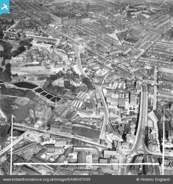
EAW047049 ENGLAND (1952). Industrial premises around Chorley Street and the Royal Bolton Infirmary, Bolton, 1952. This image was marked by Aerofilms Ltd for photo editing.
© Copyright OpenStreetMap contributors and licensed by the OpenStreetMap Foundation. 2025. Cartography is licensed as CC BY-SA.
Nearby Images (24)
Details
| Title | [EAW047049] Industrial premises around Chorley Street and the Royal Bolton Infirmary, Bolton, 1952. This image was marked by Aerofilms Ltd for photo editing. |
| Reference | EAW047049 |
| Date | September-1952 |
| Link | |
| Place name | BOLTON |
| Parish | |
| District | |
| Country | ENGLAND |
| Easting / Northing | 371135, 409389 |
| Longitude / Latitude | -2.4360211729333, 53.580058998069 |
| National Grid Reference | SD711094 |
Pins
 Oddbod |
Monday 17th of April 2017 04:23:01 PM |


![[EAW047049] Industrial premises around Chorley Street and the Royal Bolton Infirmary, Bolton, 1952. This image was marked by Aerofilms Ltd for photo editing.](http://britainfromabove.org.uk/sites/all/libraries/aerofilms-images/public/100x100/EAW/047/EAW047049.jpg)
![[EAW047046] Industrial premises around Chorley Street and the Bolton Royal Infirmary, Bolton, 1952. This image was marked by Aerofilms Ltd for photo editing.](http://britainfromabove.org.uk/sites/all/libraries/aerofilms-images/public/100x100/EAW/047/EAW047046.jpg)
![[EAW047047] Industrial premises around Chorley Street including the William Kay (Bolton) Ltd Minerva Saw Mills, Bolton, 1952. This image was marked by Aerofilms Ltd for photo editing.](http://britainfromabove.org.uk/sites/all/libraries/aerofilms-images/public/100x100/EAW/047/EAW047047.jpg)
![[EAW047045] Industrial premises around Chorley Street including the William Kay (Bolton) Ltd Minerva Saw Mills, Bolton, 1952. This image was marked by Aerofilms Ltd for photo editing.](http://britainfromabove.org.uk/sites/all/libraries/aerofilms-images/public/100x100/EAW/047/EAW047045.jpg)
![[EAW047044] Industrial premises around Chorley Street and the Bolton Royal Infirmary, Bolton, 1952. This image was marked by Aerofilms Ltd for photo editing.](http://britainfromabove.org.uk/sites/all/libraries/aerofilms-images/public/100x100/EAW/047/EAW047044.jpg)
![[EAW047048] Industrial premises around Chorley Street including the William Kay (Bolton) Ltd Minerva Saw Mills, Bolton, 1952. This image was marked by Aerofilms Ltd for photo editing.](http://britainfromabove.org.uk/sites/all/libraries/aerofilms-images/public/100x100/EAW/047/EAW047048.jpg)
![[EAW047042] William Kay (Bolton) Ltd Minerva Saw Mills on Bark Street, Bolton, 1952. This image was marked by Aerofilms Ltd for photo editing.](http://britainfromabove.org.uk/sites/all/libraries/aerofilms-images/public/100x100/EAW/047/EAW047042.jpg)
![[EAW047043] William Kay (Bolton) Ltd Minerva Saw Mills on Bark Street, Bolton, 1952. This image was marked by Aerofilms Ltd for photo editing.](http://britainfromabove.org.uk/sites/all/libraries/aerofilms-images/public/100x100/EAW/047/EAW047043.jpg)
![[EPW008993] The Borough Corn Mill and environs, Bolton, 1923](http://britainfromabove.org.uk/sites/all/libraries/aerofilms-images/public/100x100/EPW/008/EPW008993.jpg)
![[EPW008999] The Borough Corn Mill and environs, Bolton, 1923](http://britainfromabove.org.uk/sites/all/libraries/aerofilms-images/public/100x100/EPW/008/EPW008999.jpg)
![[EPW008992] The Borough Corn Mill and environs, Bolton, 1923](http://britainfromabove.org.uk/sites/all/libraries/aerofilms-images/public/100x100/EPW/008/EPW008992.jpg)
![[EPW008995] The Borough Corn Mill and environs, Bolton, 1923](http://britainfromabove.org.uk/sites/all/libraries/aerofilms-images/public/100x100/EPW/008/EPW008995.jpg)
![[EPW008997] The Borough Corn Mill and environs, Bolton, 1923](http://britainfromabove.org.uk/sites/all/libraries/aerofilms-images/public/100x100/EPW/008/EPW008997.jpg)
![[EPW008998] The Borough Corn Mill and environs, Bolton, 1923](http://britainfromabove.org.uk/sites/all/libraries/aerofilms-images/public/100x100/EPW/008/EPW008998.jpg)
![[EPW008994] The Borough Corn Mill and environs, Bolton, 1923](http://britainfromabove.org.uk/sites/all/libraries/aerofilms-images/public/100x100/EPW/008/EPW008994.jpg)
![[EPW019163] The Bolton Infirmary, Bolton, 1927](http://britainfromabove.org.uk/sites/all/libraries/aerofilms-images/public/100x100/EPW/019/EPW019163.jpg)
![[EPW008996] The Borough Corn Mill and environs, Bolton, 1923](http://britainfromabove.org.uk/sites/all/libraries/aerofilms-images/public/100x100/EPW/008/EPW008996.jpg)
![[EPW019164] The Bolton Infirmary, Bolton, 1927](http://britainfromabove.org.uk/sites/all/libraries/aerofilms-images/public/100x100/EPW/019/EPW019164.jpg)
![[EPW019162] The Bolton Infirmary, Bolton, 1927](http://britainfromabove.org.uk/sites/all/libraries/aerofilms-images/public/100x100/EPW/019/EPW019162.jpg)
![[EPW019165] The Bolton Infirmary, Bolton, 1927](http://britainfromabove.org.uk/sites/all/libraries/aerofilms-images/public/100x100/EPW/019/EPW019165.jpg)
![[EPW019167] The Bolton Infirmary and environs, Bolton, 1927](http://britainfromabove.org.uk/sites/all/libraries/aerofilms-images/public/100x100/EPW/019/EPW019167.jpg)
![[EPW019169] The Bolton Infirmary, Bolton, 1927](http://britainfromabove.org.uk/sites/all/libraries/aerofilms-images/public/100x100/EPW/019/EPW019169.jpg)
![[EPW019166] The Bolton Infirmary, Bolton, 1927](http://britainfromabove.org.uk/sites/all/libraries/aerofilms-images/public/100x100/EPW/019/EPW019166.jpg)
![[EPW019168] The Bolton Infirmary and environs, Bolton, 1927](http://britainfromabove.org.uk/sites/all/libraries/aerofilms-images/public/100x100/EPW/019/EPW019168.jpg)