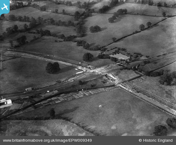
EPW009349 ENGLAND (1923). Construction of the Northern Line, Edgware, 1923
© Copyright OpenStreetMap contributors and licensed by the OpenStreetMap Foundation. 2025. Cartography is licensed as CC BY-SA.
Nearby Images (18)
Details
| Title | [EPW009349] Construction of the Northern Line, Edgware, 1923 |
| Reference | EPW009349 |
| Date | 1923 |
| Link | |
| Place name | EDGWARE |
| Parish | |
| District | |
| Country | ENGLAND |
| Easting / Northing | 519761, 191737 |
| Longitude / Latitude | -0.27021418596549, 51.611238945877 |
| National Grid Reference | TQ198917 |


![[EPW009349] Construction of the Northern Line, Edgware, 1923](http://britainfromabove.org.uk/sites/all/libraries/aerofilms-images/public/100x100/EPW/009/EPW009349.jpg)
![[EAW020694] Central Edgware and the view towards Stanmore, Edgware, from the south-east, 1948](http://britainfromabove.org.uk/sites/all/libraries/aerofilms-images/public/100x100/EAW/020/EAW020694.jpg)
![[EPW034609] A new housing estate under construction near Lower Hale, Edgware, from the south-west, 1930](http://britainfromabove.org.uk/sites/all/libraries/aerofilms-images/public/100x100/EPW/034/EPW034609.jpg)
![[EPW034615] A new housing estate under construction near Lower Hale, Edgware, from the south-west, 1930](http://britainfromabove.org.uk/sites/all/libraries/aerofilms-images/public/100x100/EPW/034/EPW034615.jpg)
![[EPW034610] A new housing estate under construction near Lower Hale, Edgware, from the south-west, 1930](http://britainfromabove.org.uk/sites/all/libraries/aerofilms-images/public/100x100/EPW/034/EPW034610.jpg)
![[EPW034613] A new housing estate under construction near Lower Hale, Edgware, from the south-west, 1930](http://britainfromabove.org.uk/sites/all/libraries/aerofilms-images/public/100x100/EPW/034/EPW034613.jpg)
![[EPW034614] A new housing estate under construction near Lower Hale, Edgware, from the south-west, 1930](http://britainfromabove.org.uk/sites/all/libraries/aerofilms-images/public/100x100/EPW/034/EPW034614.jpg)
![[EPW034554] The railway and underground stations and environs, Edgware, from the south-east, 1930](http://britainfromabove.org.uk/sites/all/libraries/aerofilms-images/public/100x100/EPW/034/EPW034554.jpg)
![[EPW034561] New housing at Orchard Crescent and environs, Edgware, from the south-west, 1930](http://britainfromabove.org.uk/sites/all/libraries/aerofilms-images/public/100x100/EPW/034/EPW034561.jpg)
![[EPW034564] New housing at Orchard Crescent and environs, Edgware, from the south-west, 1930](http://britainfromabove.org.uk/sites/all/libraries/aerofilms-images/public/100x100/EPW/034/EPW034564.jpg)
![[EPW009374] Construction of underground station, Edgware, 1923](http://britainfromabove.org.uk/sites/all/libraries/aerofilms-images/public/100x100/EPW/009/EPW009374.jpg)
![[EPW031556] Edgware Railway Station and surroundings, Edgware, from the north-west, 1930](http://britainfromabove.org.uk/sites/all/libraries/aerofilms-images/public/100x100/EPW/031/EPW031556.jpg)
![[EPW031551] Edgware London Electric Railway Station and surroundings, Edgware, from the south-west, 1930](http://britainfromabove.org.uk/sites/all/libraries/aerofilms-images/public/100x100/EPW/031/EPW031551.jpg)
![[EPW031554] Edgware London Electric Railway Station, Station Road and surroundings, Edgware, 1930](http://britainfromabove.org.uk/sites/all/libraries/aerofilms-images/public/100x100/EPW/031/EPW031554.jpg)
![[EPW034620] Housing development around Green Lane and the railway stations, Edgware, from the south-east, 1930](http://britainfromabove.org.uk/sites/all/libraries/aerofilms-images/public/100x100/EPW/034/EPW034620.jpg)
![[EPW015770] Edgware underground station, Edgware, 1926](http://britainfromabove.org.uk/sites/all/libraries/aerofilms-images/public/100x100/EPW/015/EPW015770.jpg)
![[EPW016514] The underground station and bus depot, Edgware, 1926](http://britainfromabove.org.uk/sites/all/libraries/aerofilms-images/public/100x100/EPW/016/EPW016514.jpg)
![[EPW016513] The underground station and bus depot, Edgware, 1926](http://britainfromabove.org.uk/sites/all/libraries/aerofilms-images/public/100x100/EPW/016/EPW016513.jpg)
