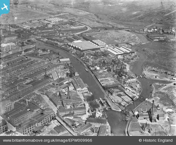
EPW009966 ENGLAND (1924). Timber yards beside the Hackney Cut Navigation, Bow, 1924
© Copyright OpenStreetMap contributors and licensed by the OpenStreetMap Foundation. 2025. Cartography is licensed as CC BY-SA.
Nearby Images (12)
Details
| Title | [EPW009966] Timber yards beside the Hackney Cut Navigation, Bow, 1924 |
| Reference | EPW009966 |
| Date | March-1924 |
| Link | |
| Place name | BOW |
| Parish | |
| District | |
| Country | ENGLAND |
| Easting / Northing | 537378, 184169 |
| Longitude / Latitude | -0.018874191185253, 51.539201768975 |
| National Grid Reference | TQ374842 |
Pins
 8-2007.JPG) Keith |
Tuesday 17th of February 2015 04:23:03 PM |


![[EPW009966] Timber yards beside the Hackney Cut Navigation, Bow, 1924](http://britainfromabove.org.uk/sites/all/libraries/aerofilms-images/public/100x100/EPW/009/EPW009966.jpg)
![[EPW009967] Timber yards beside the Hackney Cut Navigation, Bow, 1924](http://britainfromabove.org.uk/sites/all/libraries/aerofilms-images/public/100x100/EPW/009/EPW009967.jpg)
![[EAW022426] The J. Gliksten and Son Ltd timber yard on Carpenter's Road and environs, Stratford, from the south, 1949](http://britainfromabove.org.uk/sites/all/libraries/aerofilms-images/public/100x100/EAW/022/EAW022426.jpg)
![[EPW009968] Timber yards beside the Hackney Cut Navigation, Bow, 1924](http://britainfromabove.org.uk/sites/all/libraries/aerofilms-images/public/100x100/EPW/009/EPW009968.jpg)
![[EAW022425] The J. Gliksten and Son Ltd timber yard on Carpenter's Road and environs, Stratford, 1949](http://britainfromabove.org.uk/sites/all/libraries/aerofilms-images/public/100x100/EAW/022/EAW022425.jpg)
![[EAW022431] The J. Gliksten and Son Ltd timber yard on Carpenter's Road and environs, Stratford, 1949](http://britainfromabove.org.uk/sites/all/libraries/aerofilms-images/public/100x100/EAW/022/EAW022431.jpg)
![[EAW022429] The J. Gliksten and Son Ltd timber yard on Carpenter's Road and environs, Old Ford, from the west, 1949. This image has been produced from a print marked by Aerofilms Ltd for photo editing.](http://britainfromabove.org.uk/sites/all/libraries/aerofilms-images/public/100x100/EAW/022/EAW022429.jpg)
![[EAW022430] The J. Gliksten and Son Ltd timber yard on Carpenter's Road and environs, Old Ford, 1949. This image has been produced from a print marked by Aerofilms Ltd for photo editing.](http://britainfromabove.org.uk/sites/all/libraries/aerofilms-images/public/100x100/EAW/022/EAW022430.jpg)
![[EAW022427] The J. Gliksten and Son Ltd timber yard on Carpenter's Road and environs, Old Ford, 1949. This image has been produced from a print marked by Aerofilms Ltd for photo editing.](http://britainfromabove.org.uk/sites/all/libraries/aerofilms-images/public/100x100/EAW/022/EAW022427.jpg)
![[EAW022428] The J. Gliksten and Son Ltd timber yard on Carpenter's Road and environs, Old Ford, 1949. This image has been produced from a print marked by Aerofilms Ltd for photo editing.](http://britainfromabove.org.uk/sites/all/libraries/aerofilms-images/public/100x100/EAW/022/EAW022428.jpg)
![[EPW009965] Timber yards beside the Hackney Cut Navigation, Bow, 1924](http://britainfromabove.org.uk/sites/all/libraries/aerofilms-images/public/100x100/EPW/009/EPW009965.jpg)
![[EPW006771] The Clarnico Works, Bow, from the south-west, 1921](http://britainfromabove.org.uk/sites/all/libraries/aerofilms-images/public/100x100/EPW/006/EPW006771.jpg)