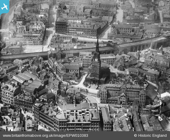
EPW010383 ENGLAND (1924). All Saints' Church and environs, Newcastle upon Tyne, 1924. This image has been produced from a print.
© Copyright OpenStreetMap contributors and licensed by the OpenStreetMap Foundation. 2025. Cartography is licensed as CC BY-SA.
Nearby Images (10)
Details
| Title | [EPW010383] All Saints' Church and environs, Newcastle upon Tyne, 1924. This image has been produced from a print. |
| Reference | EPW010383 |
| Date | April-1924 |
| Link | |
| Place name | NEWCASTLE UPON TYNE |
| Parish | |
| District | |
| Country | ENGLAND |
| Easting / Northing | 425236, 564036 |
| Longitude / Latitude | -1.6057461897686, 54.970227862704 |
| National Grid Reference | NZ252640 |


![[EPW010383] All Saints' Church and environs, Newcastle upon Tyne, 1924. This image has been produced from a print.](http://britainfromabove.org.uk/sites/all/libraries/aerofilms-images/public/100x100/EPW/010/EPW010383.jpg)
![[EAW017459] Carliol Square, Grey Street and Pilgrim Street, Newcastle upon Tyne, 1948. This image has been produced from a print.](http://britainfromabove.org.uk/sites/all/libraries/aerofilms-images/public/100x100/EAW/017/EAW017459.jpg)
![[EPW048263] Tyne Bridge and the surrounding urban area, Newcastle upon Tyne, 1935. This image has been produced from a damaged negative.](http://britainfromabove.org.uk/sites/all/libraries/aerofilms-images/public/100x100/EPW/048/EPW048263.jpg)
![[EPW025015] Newcastle-upon-Tyne, the day of the opening of the Tyne Bridge, 1928](http://britainfromabove.org.uk/sites/all/libraries/aerofilms-images/public/100x100/EPW/025/EPW025015.jpg)
![[EPW020569] The Tyne Bridge under construction, Newcastle Upon Tyne, 1928](http://britainfromabove.org.uk/sites/all/libraries/aerofilms-images/public/100x100/EPW/020/EPW020569.jpg)
![[EPW048803] Tyne Bridge, the Quayside and environs, Newcastle Upon Tyne, 1935. This image has been produced from a copy-negative.](http://britainfromabove.org.uk/sites/all/libraries/aerofilms-images/public/100x100/EPW/048/EPW048803.jpg)
![[EPW019820] Newcastle Swing Bridge, High Level Railway Bridge and Tyne Bridge under construction, Newcastle upon Tyne, 1927](http://britainfromabove.org.uk/sites/all/libraries/aerofilms-images/public/100x100/EPW/019/EPW019820.jpg)
![[EPW020570] The Tyne Bridge under construction, Newcastle Upon Tyne, 1928](http://britainfromabove.org.uk/sites/all/libraries/aerofilms-images/public/100x100/EPW/020/EPW020570.jpg)
![[EPW048799] The Tyne Bridge, Newcastle Swing Bridge and environs, Newcastle Upon Tyne, 1935](http://britainfromabove.org.uk/sites/all/libraries/aerofilms-images/public/100x100/EPW/048/EPW048799.jpg)
![[EPW048805] The High Level Bridge, Newcastle Swing Bridge, Tyne Bridge and the city, Newcastle upon Tyne, from the south-west, 1935. This image has been produced from a print.](http://britainfromabove.org.uk/sites/all/libraries/aerofilms-images/public/100x100/EPW/048/EPW048805.jpg)
