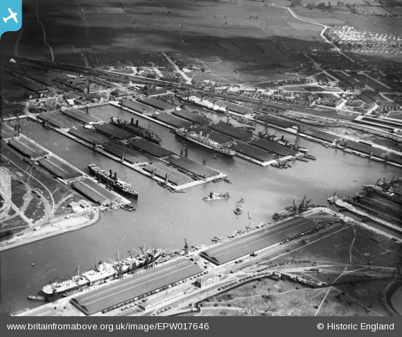
EPW017646 ENGLAND (1927). The Docks, Tilbury, 1927
© Copyright OpenStreetMap contributors and licensed by the OpenStreetMap Foundation. 2025. Cartography is licensed as CC BY-SA.
Nearby Images (28)
Details
| Title | [EPW017646] The Docks, Tilbury, 1927 |
| Reference | EPW017646 |
| Date | April-1927 |
| Link | |
| Place name | TILBURY |
| Parish | |
| District | |
| Country | ENGLAND |
| Easting / Northing | 563583, 175762 |
| Longitude / Latitude | 0.3548133179117, 51.456679504479 |
| National Grid Reference | TQ636758 |
Pins
 cambria |
Friday 23rd of July 2021 03:08:17 PM | |
 MB |
Thursday 20th of September 2012 11:23:28 AM | |
 BigglesH |
Tuesday 17th of July 2012 12:19:24 AM | |
 BigglesH |
Tuesday 17th of July 2012 12:17:04 AM | |
Bucket dredger |
 MB |
Thursday 20th of September 2012 11:24:16 AM |
 BigglesH |
Tuesday 17th of July 2012 12:15:22 AM | |
Pub's name was "The Ship". |
 BigglesH |
Wednesday 25th of July 2012 04:13:37 PM |
 BigglesH |
Tuesday 17th of July 2012 12:11:09 AM | |
 BigglesH |
Tuesday 17th of July 2012 12:09:02 AM | |
 BigglesH |
Tuesday 17th of July 2012 12:05:59 AM | |
 BigglesH |
Tuesday 17th of July 2012 12:03:59 AM | |
 BigglesH |
Tuesday 17th of July 2012 12:01:46 AM | |
 BigglesH |
Tuesday 17th of July 2012 12:00:05 AM |


![[EPW017646] The Docks, Tilbury, 1927](http://britainfromabove.org.uk/sites/all/libraries/aerofilms-images/public/100x100/EPW/017/EPW017646.jpg)
![[EPW032810] Tilbury Docks, Tilbury, 1930](http://britainfromabove.org.uk/sites/all/libraries/aerofilms-images/public/100x100/EPW/032/EPW032810.jpg)
![[EPW018636] The Docks, Tilbury, 1927](http://britainfromabove.org.uk/sites/all/libraries/aerofilms-images/public/100x100/EPW/018/EPW018636.jpg)
![[EPW001398] Tilbury Docks, Tilbury, 1920](http://britainfromabove.org.uk/sites/all/libraries/aerofilms-images/public/100x100/EPW/001/EPW001398.jpg)
![[EPW044220] Tilbury Docks, Tilbury, 1934](http://britainfromabove.org.uk/sites/all/libraries/aerofilms-images/public/100x100/EPW/044/EPW044220.jpg)
![[EAW028812] Tilbury Docks and the River Thames, Tilbury, 1950](http://britainfromabove.org.uk/sites/all/libraries/aerofilms-images/public/100x100/EAW/028/EAW028812.jpg)
![[EPW018637] The Docks, Tilbury, 1927](http://britainfromabove.org.uk/sites/all/libraries/aerofilms-images/public/100x100/EPW/018/EPW018637.jpg)
![[EPW032807] Orient Steam Navigation Company Liners in Tilbury Docks, Tilbury, 1930](http://britainfromabove.org.uk/sites/all/libraries/aerofilms-images/public/100x100/EPW/032/EPW032807.jpg)
![[EPW032812] Orient Steam Navigation Company Liners in Tilbury Docks, Tilbury, 1930](http://britainfromabove.org.uk/sites/all/libraries/aerofilms-images/public/100x100/EPW/032/EPW032812.jpg)
![[EPW006261] Tilbury Docks, Tilbury, 1921](http://britainfromabove.org.uk/sites/all/libraries/aerofilms-images/public/100x100/EPW/006/EPW006261.jpg)
![[EPW001396] Tilbury Docks, Tilbury, 1920](http://britainfromabove.org.uk/sites/all/libraries/aerofilms-images/public/100x100/EPW/001/EPW001396.jpg)
![[EPW032804] Orient Steam Navigation Company Liners in Tilbury Docks, Tilbury, 1930](http://britainfromabove.org.uk/sites/all/libraries/aerofilms-images/public/100x100/EPW/032/EPW032804.jpg)
![[EPW032811] Orient Steam Navigation Company Liners in Tilbury Docks, Tilbury, 1930](http://britainfromabove.org.uk/sites/all/libraries/aerofilms-images/public/100x100/EPW/032/EPW032811.jpg)
![[EPW044211] Tilbury Docks and environs, Tilbury, 1934](http://britainfromabove.org.uk/sites/all/libraries/aerofilms-images/public/100x100/EPW/044/EPW044211.jpg)
![[EAW028808] Tilbury Docks, Tilbury, 1950](http://britainfromabove.org.uk/sites/all/libraries/aerofilms-images/public/100x100/EAW/028/EAW028808.jpg)
![[EPW032808] Orient Steam Navigation Company Liners in Tilbury Docks, Tilbury, 1930](http://britainfromabove.org.uk/sites/all/libraries/aerofilms-images/public/100x100/EPW/032/EPW032808.jpg)
![[EPW032802] Orient Steam Navigation Company Liners in Tilbury Docks, Tilbury, 1930](http://britainfromabove.org.uk/sites/all/libraries/aerofilms-images/public/100x100/EPW/032/EPW032802.jpg)
![[EPW032809] Tilbury Docks, Tilbury, 1930](http://britainfromabove.org.uk/sites/all/libraries/aerofilms-images/public/100x100/EPW/032/EPW032809.jpg)
![[EAW028813] Tilbury Docks and the River Thames, Tilbury, 1950](http://britainfromabove.org.uk/sites/all/libraries/aerofilms-images/public/100x100/EAW/028/EAW028813.jpg)
![[EAW028810] Tilbury Docks, Tilbury, 1950](http://britainfromabove.org.uk/sites/all/libraries/aerofilms-images/public/100x100/EAW/028/EAW028810.jpg)
![[EAW028809] Tilbury Docks, Tilbury, 1950](http://britainfromabove.org.uk/sites/all/libraries/aerofilms-images/public/100x100/EAW/028/EAW028809.jpg)
![[EPW001397] Tilbury Docks, Tilbury, 1920](http://britainfromabove.org.uk/sites/all/libraries/aerofilms-images/public/100x100/EPW/001/EPW001397.jpg)
![[EPR000362] Tilbury Docks, Tilbury, 1934](http://britainfromabove.org.uk/sites/all/libraries/aerofilms-images/public/100x100/EPR/000/EPR000362.jpg)
![[EAW020324] Tilbury Docks, Tilbury, 1948. This image has been produced from a print.](http://britainfromabove.org.uk/sites/all/libraries/aerofilms-images/public/100x100/EAW/020/EAW020324.jpg)
![[EPW044221] Tilbury Docks, Tilbury, 1934](http://britainfromabove.org.uk/sites/all/libraries/aerofilms-images/public/100x100/EPW/044/EPW044221.jpg)
![[EAW042098] Tilbury Docks, Tilbury, 1952](http://britainfromabove.org.uk/sites/all/libraries/aerofilms-images/public/100x100/EAW/042/EAW042098.jpg)
![[EPR000361] Tilbury Docks, Tilbury, 1934](http://britainfromabove.org.uk/sites/all/libraries/aerofilms-images/public/100x100/EPR/000/EPR000361.jpg)
![[EAW002338] Tilbury Docks, Tilbury, 1946](http://britainfromabove.org.uk/sites/all/libraries/aerofilms-images/public/100x100/EAW/002/EAW002338.jpg)