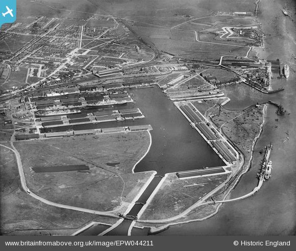
EPW044211 ENGLAND (1934). Tilbury Docks and environs, Tilbury, 1934
© Copyright OpenStreetMap contributors and licensed by the OpenStreetMap Foundation. 2025. Cartography is licensed as CC BY-SA.
Nearby Images (21)
Details
| Title | [EPW044211] Tilbury Docks and environs, Tilbury, 1934 |
| Reference | EPW044211 |
| Date | May-1934 |
| Link | |
| Place name | TILBURY |
| Parish | |
| District | |
| Country | ENGLAND |
| Easting / Northing | 563495, 175629 |
| Longitude / Latitude | 0.35348619987635, 51.455509926023 |
| National Grid Reference | TQ635756 |
Pins
 Blifster |
Tuesday 11th of February 2014 10:13:43 AM | |
 Blifster |
Tuesday 11th of February 2014 10:12:53 AM | |
 Blifster |
Tuesday 11th of February 2014 10:12:11 AM | |
 Blifster |
Tuesday 11th of February 2014 10:11:51 AM | |
 Blifster |
Tuesday 11th of February 2014 10:11:20 AM |


![[EPW044211] Tilbury Docks and environs, Tilbury, 1934](http://britainfromabove.org.uk/sites/all/libraries/aerofilms-images/public/100x100/EPW/044/EPW044211.jpg)
![[EPW006261] Tilbury Docks, Tilbury, 1921](http://britainfromabove.org.uk/sites/all/libraries/aerofilms-images/public/100x100/EPW/006/EPW006261.jpg)
![[EAW028810] Tilbury Docks, Tilbury, 1950](http://britainfromabove.org.uk/sites/all/libraries/aerofilms-images/public/100x100/EAW/028/EAW028810.jpg)
![[EPW018636] The Docks, Tilbury, 1927](http://britainfromabove.org.uk/sites/all/libraries/aerofilms-images/public/100x100/EPW/018/EPW018636.jpg)
![[EAW028813] Tilbury Docks and the River Thames, Tilbury, 1950](http://britainfromabove.org.uk/sites/all/libraries/aerofilms-images/public/100x100/EAW/028/EAW028813.jpg)
![[EAW028809] Tilbury Docks, Tilbury, 1950](http://britainfromabove.org.uk/sites/all/libraries/aerofilms-images/public/100x100/EAW/028/EAW028809.jpg)
![[EPW032810] Tilbury Docks, Tilbury, 1930](http://britainfromabove.org.uk/sites/all/libraries/aerofilms-images/public/100x100/EPW/032/EPW032810.jpg)
![[EPW032809] Tilbury Docks, Tilbury, 1930](http://britainfromabove.org.uk/sites/all/libraries/aerofilms-images/public/100x100/EPW/032/EPW032809.jpg)
![[EPW001398] Tilbury Docks, Tilbury, 1920](http://britainfromabove.org.uk/sites/all/libraries/aerofilms-images/public/100x100/EPW/001/EPW001398.jpg)
![[EPW044215] Tilbury Docks, Tilbury, 1934](http://britainfromabove.org.uk/sites/all/libraries/aerofilms-images/public/100x100/EPW/044/EPW044215.jpg)
![[EAW028812] Tilbury Docks and the River Thames, Tilbury, 1950](http://britainfromabove.org.uk/sites/all/libraries/aerofilms-images/public/100x100/EAW/028/EAW028812.jpg)
![[EPW017646] The Docks, Tilbury, 1927](http://britainfromabove.org.uk/sites/all/libraries/aerofilms-images/public/100x100/EPW/017/EPW017646.jpg)
![[EPW044214] Tilbury Docks, Tilbury, 1934](http://britainfromabove.org.uk/sites/all/libraries/aerofilms-images/public/100x100/EPW/044/EPW044214.jpg)
![[EPR000362] Tilbury Docks, Tilbury, 1934](http://britainfromabove.org.uk/sites/all/libraries/aerofilms-images/public/100x100/EPR/000/EPR000362.jpg)
![[EAW028808] Tilbury Docks, Tilbury, 1950](http://britainfromabove.org.uk/sites/all/libraries/aerofilms-images/public/100x100/EAW/028/EAW028808.jpg)
![[EPW032812] Orient Steam Navigation Company Liners in Tilbury Docks, Tilbury, 1930](http://britainfromabove.org.uk/sites/all/libraries/aerofilms-images/public/100x100/EPW/032/EPW032812.jpg)
![[EPW032807] Orient Steam Navigation Company Liners in Tilbury Docks, Tilbury, 1930](http://britainfromabove.org.uk/sites/all/libraries/aerofilms-images/public/100x100/EPW/032/EPW032807.jpg)
![[EPW044220] Tilbury Docks, Tilbury, 1934](http://britainfromabove.org.uk/sites/all/libraries/aerofilms-images/public/100x100/EPW/044/EPW044220.jpg)
![[EAW042098] Tilbury Docks, Tilbury, 1952](http://britainfromabove.org.uk/sites/all/libraries/aerofilms-images/public/100x100/EAW/042/EAW042098.jpg)
![[EAW002337] Tilbury Docks, Tilbury, 1946](http://britainfromabove.org.uk/sites/all/libraries/aerofilms-images/public/100x100/EAW/002/EAW002337.jpg)
![[EPW018637] The Docks, Tilbury, 1927](http://britainfromabove.org.uk/sites/all/libraries/aerofilms-images/public/100x100/EPW/018/EPW018637.jpg)