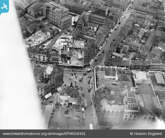
EPW018431 ENGLAND (1927). The junction of Gallowtree Gate and Halford Street, Leicester, 1927
© Copyright OpenStreetMap contributors and licensed by the OpenStreetMap Foundation. 2025. Cartography is licensed as CC BY-SA.
Nearby Images (36)
Details
| Title | [EPW018431] The junction of Gallowtree Gate and Halford Street, Leicester, 1927 |
| Reference | EPW018431 |
| Date | 10-June-1927 |
| Link | |
| Place name | LEICESTER |
| Parish | |
| District | |
| Country | ENGLAND |
| Easting / Northing | 458874, 304448 |
| Longitude / Latitude | -1.1299701215397, 52.634234159226 |
| National Grid Reference | SK589044 |
Pins
 LisB |
Wednesday 21st of June 2023 06:11:13 PM | |
 Class31 |
Saturday 9th of February 2013 11:29:55 PM | |
 Class31 |
Saturday 9th of February 2013 11:26:29 PM | |
 Class31 |
Saturday 9th of February 2013 11:25:43 PM | |
 Class31 |
Saturday 9th of February 2013 11:22:45 PM | |
 deeb |
Sunday 9th of December 2012 02:02:50 PM | |
This would be Gallowtree Gate with Halford Street on the right going up to top right. We can see the alterations to 'Woolworths' now 'BHS' occupies this spot. |
 Underwood55 |
Tuesday 11th of December 2012 08:12:43 PM |
Yep Underwood is right |
 Birstall |
Wednesday 19th of December 2012 02:02:56 PM |
 deeb |
Sunday 9th of December 2012 02:01:57 PM | |
This is Halford Street. |
 Underwood55 |
Tuesday 11th of December 2012 08:13:27 PM |
This is where Horsefair Street, Granby St, Halford St, and Gallowtree Gate conjoin. The photo is looking East so Horsefair St is at the bottom and the entrance to the market is on the left hand side of the street. |
 Birstall |
Wednesday 19th of December 2012 02:01:53 PM |


![[EPW018431] The junction of Gallowtree Gate and Halford Street, Leicester, 1927](http://britainfromabove.org.uk/sites/all/libraries/aerofilms-images/public/100x100/EPW/018/EPW018431.jpg)
![[EAW024240] Charles Street, Granby Street and the city centre, Leicester, 1949](http://britainfromabove.org.uk/sites/all/libraries/aerofilms-images/public/100x100/EAW/024/EAW024240.jpg)
![[EPW018436] Town Hall Square and environs, Leicester, 1927](http://britainfromabove.org.uk/sites/all/libraries/aerofilms-images/public/100x100/EPW/018/EPW018436.jpg)
![[EPW018412] The city by the junction of Gallowtree Gate and Horsefair Street, Leicester, 1927. This image has been produced from a copy-negative.](http://britainfromabove.org.uk/sites/all/libraries/aerofilms-images/public/100x100/EPW/018/EPW018412.jpg)
![[EPW020892] The Town Square and city centre, Leicester, 1928](http://britainfromabove.org.uk/sites/all/libraries/aerofilms-images/public/100x100/EPW/020/EPW020892.jpg)
![[EPW018421] The Town Hall, Horsefair Street and environs, Leicester, 1927. This image has been produced from a print.](http://britainfromabove.org.uk/sites/all/libraries/aerofilms-images/public/100x100/EPW/018/EPW018421.jpg)
![[EAW051834] The city centre around High Street and Humberstone Gate, Leicester, 1953](http://britainfromabove.org.uk/sites/all/libraries/aerofilms-images/public/100x100/EAW/051/EAW051834.jpg)
![[EPW018422] Gallowtree Gate and environs, Leicester, 1927. This image has been produced from a print.](http://britainfromabove.org.uk/sites/all/libraries/aerofilms-images/public/100x100/EPW/018/EPW018422.jpg)
![[EPW055011] Charles Street and the city centre, Leicester, 1937](http://britainfromabove.org.uk/sites/all/libraries/aerofilms-images/public/100x100/EPW/055/EPW055011.jpg)
![[EAW024242] Gallowtree Gate, Cheapside and the city centre, Leicester, 1949](http://britainfromabove.org.uk/sites/all/libraries/aerofilms-images/public/100x100/EAW/024/EAW024242.jpg)
![[EAW024244] Charles Street and the city centre, Leicester, 1949](http://britainfromabove.org.uk/sites/all/libraries/aerofilms-images/public/100x100/EAW/024/EAW024244.jpg)
![[EPW047868] Bishop Street and environs, Leicester, 1935](http://britainfromabove.org.uk/sites/all/libraries/aerofilms-images/public/100x100/EPW/047/EPW047868.jpg)
![[EAW024239] Humberstone Gate, Charles Street and the city centre, Leicester, 1949](http://britainfromabove.org.uk/sites/all/libraries/aerofilms-images/public/100x100/EAW/024/EAW024239.jpg)
![[EPW055002] The city around Belvoir Street and Granby Street, Leicester, 1937](http://britainfromabove.org.uk/sites/all/libraries/aerofilms-images/public/100x100/EPW/055/EPW055002.jpg)
![[EAW024243] The Clock Tower, Humberstone Gate and the city centre, Leicester, 1949](http://britainfromabove.org.uk/sites/all/libraries/aerofilms-images/public/100x100/EAW/024/EAW024243.jpg)
![[EPW018433] East Gates and environs, Leicester, 1927](http://britainfromabove.org.uk/sites/all/libraries/aerofilms-images/public/100x100/EPW/018/EPW018433.jpg)
![[EPW047643] The Clock Tower and the city centre, Leicester, 1935](http://britainfromabove.org.uk/sites/all/libraries/aerofilms-images/public/100x100/EPW/047/EPW047643.jpg)
![[EPW055009] Charles Street, St George's Church and the city, Leicester, 1937](http://britainfromabove.org.uk/sites/all/libraries/aerofilms-images/public/100x100/EPW/055/EPW055009.jpg)
![[EAW052680] Arthur Foister and Sons Ltd (Cherub Ltd) Factory on Charles Street, Leicester, 1953. This image was marked by Aerofilms Ltd for photo editing.](http://britainfromabove.org.uk/sites/all/libraries/aerofilms-images/public/100x100/EAW/052/EAW052680.jpg)
![[EPW047645] The city centre, Leicester, 1935](http://britainfromabove.org.uk/sites/all/libraries/aerofilms-images/public/100x100/EPW/047/EPW047645.jpg)
![[EPW061211] The city centre, Leicester, 1939](http://britainfromabove.org.uk/sites/all/libraries/aerofilms-images/public/100x100/EPW/061/EPW061211.jpg)
![[EPW020824] Belvoir Street, Town Hall Square and environs, Leicester, 1928. This image has been produced from a copy-negative.](http://britainfromabove.org.uk/sites/all/libraries/aerofilms-images/public/100x100/EPW/020/EPW020824.jpg)
![[EPW020895] The city centre, Leicester, 1928](http://britainfromabove.org.uk/sites/all/libraries/aerofilms-images/public/100x100/EPW/020/EPW020895.jpg)
![[EPW061213] Charles Street and environs, Leicester, 1939](http://britainfromabove.org.uk/sites/all/libraries/aerofilms-images/public/100x100/EPW/061/EPW061213.jpg)
![[EPW047641] The Haymarket and city centre, Leicester, 1935](http://britainfromabove.org.uk/sites/all/libraries/aerofilms-images/public/100x100/EPW/047/EPW047641.jpg)
![[EAW052674] Arthur Foister & Sons Ltd (Cherub Ltd) Factory on Charles Street, St George's Church and Rutland Street, Leicester, 1953. This image was marked by Aerofilms Ltd for photo editing.](http://britainfromabove.org.uk/sites/all/libraries/aerofilms-images/public/100x100/EAW/052/EAW052674.jpg)
![[EAW052676] Arthur Foister & Sons Ltd (Cherub Ltd) Factory on Charles Street and St George's Church, Leicester, 1953. This image was marked by Aerofilms Ltd for photo editing.](http://britainfromabove.org.uk/sites/all/libraries/aerofilms-images/public/100x100/EAW/052/EAW052676.jpg)
![[EPW020819] Belvoir Street and environs, Leicester, 1928](http://britainfromabove.org.uk/sites/all/libraries/aerofilms-images/public/100x100/EPW/020/EPW020819.jpg)
![[EAW052675] Arthur Foister & Sons Ltd (Cherub Ltd) Factory on Charles Street, Leicester, 1953. This image was marked by Aerofilms Ltd for photo editing.](http://britainfromabove.org.uk/sites/all/libraries/aerofilms-images/public/100x100/EAW/052/EAW052675.jpg)
![[EPW055006] The Haymarket and the city centre, Leicester, 1937](http://britainfromabove.org.uk/sites/all/libraries/aerofilms-images/public/100x100/EPW/055/EPW055006.jpg)
![[EAW052679] Colton Street and Arthur Foister and Sons Ltd (Cherub Ltd) Factory on Charles Street, Leicester, 1953. This image was marked by Aerofilms Ltd for photo editing.](http://britainfromabove.org.uk/sites/all/libraries/aerofilms-images/public/100x100/EAW/052/EAW052679.jpg)
![[EPW020817] Belvoir Street and environs, Leicester, 1928](http://britainfromabove.org.uk/sites/all/libraries/aerofilms-images/public/100x100/EPW/020/EPW020817.jpg)
![[EPW020822] Belvoir Street and environs, Leicester, 1928. This image has been produced from a copy-negative.](http://britainfromabove.org.uk/sites/all/libraries/aerofilms-images/public/100x100/EPW/020/EPW020822.jpg)
![[EPW020815] Market Street and environs, Leicester, 1928](http://britainfromabove.org.uk/sites/all/libraries/aerofilms-images/public/100x100/EPW/020/EPW020815.jpg)
![[EPW055010] The city centre, Leicester, from the south-west, 1937](http://britainfromabove.org.uk/sites/all/libraries/aerofilms-images/public/100x100/EPW/055/EPW055010.jpg)
![[EPW020826] Welford Place and environs, Leicester, 1928. This image has been produced from a print.](http://britainfromabove.org.uk/sites/all/libraries/aerofilms-images/public/100x100/EPW/020/EPW020826.jpg)