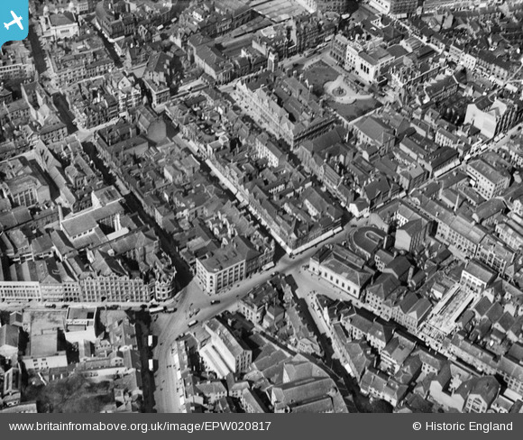
EPW020817 ENGLAND (1928). Belvoir Street and environs, Leicester, 1928
© Copyright OpenStreetMap contributors and licensed by the OpenStreetMap Foundation. 2025. Cartography is licensed as CC BY-SA.
Nearby Images (24)
Details
| Title | [EPW020817] Belvoir Street and environs, Leicester, 1928 |
| Reference | EPW020817 |
| Date | April-1928 |
| Link | |
| Place name | LEICESTER |
| Parish | |
| District | |
| Country | ENGLAND |
| Easting / Northing | 458769, 304215 |
| Longitude / Latitude | -1.131563075737, 52.632150932185 |
| National Grid Reference | SK588042 |
Pins
User Comment Contributions
Town hall and square top of picture just right of centre. Start of Welford Rd at junction with Newarke Street bottom left (zoom in to see tram lines and a clearly different traffic flow. |
 Timboishere |
Thursday 28th of June 2012 02:20:11 PM |


![[EPW020817] Belvoir Street and environs, Leicester, 1928](http://britainfromabove.org.uk/sites/all/libraries/aerofilms-images/public/100x100/EPW/020/EPW020817.jpg)
![[EPW020815] Market Street and environs, Leicester, 1928](http://britainfromabove.org.uk/sites/all/libraries/aerofilms-images/public/100x100/EPW/020/EPW020815.jpg)
![[EPW020819] Belvoir Street and environs, Leicester, 1928](http://britainfromabove.org.uk/sites/all/libraries/aerofilms-images/public/100x100/EPW/020/EPW020819.jpg)
![[EPW020824] Belvoir Street, Town Hall Square and environs, Leicester, 1928. This image has been produced from a copy-negative.](http://britainfromabove.org.uk/sites/all/libraries/aerofilms-images/public/100x100/EPW/020/EPW020824.jpg)
![[EPW020816] Welford Place and environs, Leicester, 1928](http://britainfromabove.org.uk/sites/all/libraries/aerofilms-images/public/100x100/EPW/020/EPW020816.jpg)
![[EPW020822] Belvoir Street and environs, Leicester, 1928. This image has been produced from a copy-negative.](http://britainfromabove.org.uk/sites/all/libraries/aerofilms-images/public/100x100/EPW/020/EPW020822.jpg)
![[EPW018415] Welford Place and environs, Leicester, 1927. This image has been produced from a print.](http://britainfromabove.org.uk/sites/all/libraries/aerofilms-images/public/100x100/EPW/018/EPW018415.jpg)
![[EAW024241] The city centre, Leicester, 1949](http://britainfromabove.org.uk/sites/all/libraries/aerofilms-images/public/100x100/EAW/024/EAW024241.jpg)
![[EPW018461] Welford Place and Newarke Street, Leicester, 1927. This image has been produced from a print.](http://britainfromabove.org.uk/sites/all/libraries/aerofilms-images/public/100x100/EPW/018/EPW018461.jpg)
![[EPW020825] Welford Place, Leicester, 1928. This image has been produced from a print.](http://britainfromabove.org.uk/sites/all/libraries/aerofilms-images/public/100x100/EPW/020/EPW020825.jpg)
![[EPW020826] Welford Place and environs, Leicester, 1928. This image has been produced from a print.](http://britainfromabove.org.uk/sites/all/libraries/aerofilms-images/public/100x100/EPW/020/EPW020826.jpg)
![[EPW020814] Pocklingtons Walk and environs, Leicester, 1928](http://britainfromabove.org.uk/sites/all/libraries/aerofilms-images/public/100x100/EPW/020/EPW020814.jpg)
![[EPW020818] Pocklingtons Walk and environs, Leicester, 1928](http://britainfromabove.org.uk/sites/all/libraries/aerofilms-images/public/100x100/EPW/020/EPW020818.jpg)
![[EAW051830] The city centre, Leicester, from the west, 1953](http://britainfromabove.org.uk/sites/all/libraries/aerofilms-images/public/100x100/EAW/051/EAW051830.jpg)
![[EPW055010] The city centre, Leicester, from the south-west, 1937](http://britainfromabove.org.uk/sites/all/libraries/aerofilms-images/public/100x100/EPW/055/EPW055010.jpg)
![[EAW051828] The city, Leicester, from the west, 1953](http://britainfromabove.org.uk/sites/all/libraries/aerofilms-images/public/100x100/EAW/051/EAW051828.jpg)
![[EPW047868] Bishop Street and environs, Leicester, 1935](http://britainfromabove.org.uk/sites/all/libraries/aerofilms-images/public/100x100/EPW/047/EPW047868.jpg)
![[EPW018421] The Town Hall, Horsefair Street and environs, Leicester, 1927. This image has been produced from a print.](http://britainfromabove.org.uk/sites/all/libraries/aerofilms-images/public/100x100/EPW/018/EPW018421.jpg)
![[EPW020892] The Town Square and city centre, Leicester, 1928](http://britainfromabove.org.uk/sites/all/libraries/aerofilms-images/public/100x100/EPW/020/EPW020892.jpg)
![[EPW061211] The city centre, Leicester, 1939](http://britainfromabove.org.uk/sites/all/libraries/aerofilms-images/public/100x100/EPW/061/EPW061211.jpg)
![[EPW018436] Town Hall Square and environs, Leicester, 1927](http://britainfromabove.org.uk/sites/all/libraries/aerofilms-images/public/100x100/EPW/018/EPW018436.jpg)
![[EPW047642] The city centre, Leicester, from the south-west, 1935](http://britainfromabove.org.uk/sites/all/libraries/aerofilms-images/public/100x100/EPW/047/EPW047642.jpg)
![[EPW018431] The junction of Gallowtree Gate and Halford Street, Leicester, 1927](http://britainfromabove.org.uk/sites/all/libraries/aerofilms-images/public/100x100/EPW/018/EPW018431.jpg)
![[EAW024240] Charles Street, Granby Street and the city centre, Leicester, 1949](http://britainfromabove.org.uk/sites/all/libraries/aerofilms-images/public/100x100/EAW/024/EAW024240.jpg)