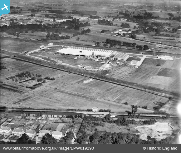
EPW019293 ENGLAND (1927). The Daimler Motor Works, Southall, 1927
© Copyright OpenStreetMap contributors and licensed by the OpenStreetMap Foundation. 2025. Cartography is licensed as CC BY-SA.
Nearby Images (22)
Details
| Title | [EPW019293] The Daimler Motor Works, Southall, 1927 |
| Reference | EPW019293 |
| Date | September-1927 |
| Link | |
| Place name | SOUTHALL |
| Parish | |
| District | |
| Country | ENGLAND |
| Easting / Northing | 513769, 179780 |
| Longitude / Latitude | -0.3605910880709, 51.505003778229 |
| National Grid Reference | TQ138798 |
Pins
 Mozzy |
Friday 26th of December 2014 10:25:32 AM | |
 D Figueiredo |
Thursday 20th of December 2012 02:20:40 PM | |
 D Figueiredo |
Thursday 20th of December 2012 02:19:55 PM | |
 Simon Judge |
Monday 27th of August 2012 07:00:17 PM |
User Comment Contributions
This is definitely the bottom Norwood Lock 91 with the now demolished lock cottage. |
 D Figueiredo |
Thursday 20th of December 2012 02:18:45 PM |


![[EPW019293] The Daimler Motor Works, Southall, 1927](http://britainfromabove.org.uk/sites/all/libraries/aerofilms-images/public/100x100/EPW/019/EPW019293.jpg)
![[EAW018654] The Associated Equipment Company (AEC) Motor Works and the surrounding area, Southall, 1948. This image was marked by Aerofilms Ltd for photo editing.](http://britainfromabove.org.uk/sites/all/libraries/aerofilms-images/public/100x100/EAW/018/EAW018654.jpg)
![[EPW017381] The Associated Daimler Company (ADC) motor works, Southall, 1927](http://britainfromabove.org.uk/sites/all/libraries/aerofilms-images/public/100x100/EPW/017/EPW017381.jpg)
![[EPW017382] The Associated Daimler Company (ADC) motor works, Southall, 1927](http://britainfromabove.org.uk/sites/all/libraries/aerofilms-images/public/100x100/EPW/017/EPW017382.jpg)
![[EPW019284] The Daimler Motor Works, Southall, 1927](http://britainfromabove.org.uk/sites/all/libraries/aerofilms-images/public/100x100/EPW/019/EPW019284.jpg)
![[EAW018650] The Associated Equipment Company (AEC) Motor Works and environs, Southall, 1948. This image has been produced from a print marked by Aerofilms Ltd for photo editing.](http://britainfromabove.org.uk/sites/all/libraries/aerofilms-images/public/100x100/EAW/018/EAW018650.jpg)
![[EPW019285] The Daimler Motor Works, Southall, 1927](http://britainfromabove.org.uk/sites/all/libraries/aerofilms-images/public/100x100/EPW/019/EPW019285.jpg)
![[EPW031710] The Associated Equipment Co Motor Works, Southall, 1930](http://britainfromabove.org.uk/sites/all/libraries/aerofilms-images/public/100x100/EPW/031/EPW031710.jpg)
![[EPW019283] The Daimler Motor Works, Southall, 1927](http://britainfromabove.org.uk/sites/all/libraries/aerofilms-images/public/100x100/EPW/019/EPW019283.jpg)
![[EPW019280] The Daimler Motor Works, Southall, 1927](http://britainfromabove.org.uk/sites/all/libraries/aerofilms-images/public/100x100/EPW/019/EPW019280.jpg)
![[EPW019289] The Daimler Motor Works, Southall, 1927](http://britainfromabove.org.uk/sites/all/libraries/aerofilms-images/public/100x100/EPW/019/EPW019289.jpg)
![[EAW018651] The Associated Equipment Company (AEC) Motor Works (site of), Southall, 1948. This image has been produced from a damaged negative.](http://britainfromabove.org.uk/sites/all/libraries/aerofilms-images/public/100x100/EAW/018/EAW018651.jpg)
![[EPW019290] The Daimler Motor Works, Southall, 1927](http://britainfromabove.org.uk/sites/all/libraries/aerofilms-images/public/100x100/EPW/019/EPW019290.jpg)
![[EPW019287] The Daimler Motor Works, Southall, 1927](http://britainfromabove.org.uk/sites/all/libraries/aerofilms-images/public/100x100/EPW/019/EPW019287.jpg)
![[EPW019291] The Daimler Motor Works, Southall, 1927](http://britainfromabove.org.uk/sites/all/libraries/aerofilms-images/public/100x100/EPW/019/EPW019291.jpg)
![[EAW018659] The Associated Equipment Company (AEC) Motor Works, Southall, 1948. This image was marked by Aerofilms Ltd for photo editing.](http://britainfromabove.org.uk/sites/all/libraries/aerofilms-images/public/100x100/EAW/018/EAW018659.jpg)
![[EAW018656] The Associated Equipment Company (AEC) Motor Works, Southall, 1948. This image was marked by Aerofilms Ltd for photo editing.](http://britainfromabove.org.uk/sites/all/libraries/aerofilms-images/public/100x100/EAW/018/EAW018656.jpg)
![[EPW017383] The Associated Daimler Company (ADC) motor works, Southall, 1927](http://britainfromabove.org.uk/sites/all/libraries/aerofilms-images/public/100x100/EPW/017/EPW017383.jpg)
![[EAW018657] The Associated Equipment Company (AEC) Motor Works, Southall, 1948](http://britainfromabove.org.uk/sites/all/libraries/aerofilms-images/public/100x100/EAW/018/EAW018657.jpg)
![[EPW019281] The Daimler Motor Works and environs, Southall, 1927](http://britainfromabove.org.uk/sites/all/libraries/aerofilms-images/public/100x100/EPW/019/EPW019281.jpg)
![[EPW019282] The Daimler Motor Works and environs, Southall, 1927](http://britainfromabove.org.uk/sites/all/libraries/aerofilms-images/public/100x100/EPW/019/EPW019282.jpg)
![[EPW019288] The Daimler Motor Works, Southall, 1927](http://britainfromabove.org.uk/sites/all/libraries/aerofilms-images/public/100x100/EPW/019/EPW019288.jpg)